 | | Report (issue) | | CALITI ES OF UTAH by Kenneth C. Bullock UTAH GEOLOGICAL AND MINERAL SURVEY a division of the UTAH DEPARTMENT...JANUARY 1981 MINERALS AND MINERAL LOCALITIES OF UTAH by Kenneth C. Bullock Nature displays her most.... . . . . . 1 Chapter I. Mining Districts of Counties and the State of Utah. . . . . . . . . . . . .... . . . . . . . . . . . . . . . . . . . . . . 1 County Listings. . . . . . . . . . . . . . . . . . . .... . . . . . . . . . . . 1 Chapter II. Mining Districts of Utah . . . . . . . . . . . . . . . . . . . |  | | Report (issue) | | Selected Mining Districts of Utah by Carl L. Ege Headframe of Centennial Eureka mine, Tintic mining district...MISCELLANEOUS PUBLICATION 05-5 UTAH GEOLOGICAL SURVEY a division of 2005 Utah Department of Natural Resources...Resources STATE OF UTAH Jon Huntsman, Jr., Governor DEPARTMENT OF NATURAL RESOURCES Michael Styler, Executive...Executive Director UTAH GEOLOGICAL SURVEY Richard G. Allis, Director PUBLICATIONS contact Natural Resources...toll-free: 1-888-UTAH MAP website: http://mapstore.utah.gov email: geostore@utah.gov THE UTAH GEOLOGICAL SURVEY |  | | Journal (volume) | | 1915 The Salt Lake Mining Review 1601 Walker Bank Building SALT LAKE CITY , UTAH 2 620.05 SI V.16... 18 19 Pack Creek , Utah , Has Large, Rich Carnotite Deposits . Silver King Con . Statement Self- Cotained... Editorial Make the Prospect Pay. Editorial The Utah Products Show The Prospector and His Burro . By:...1914. The Utah Consolidated Stone Co. The Nevada . : Items : The Cameron Coal Mines , Utah Detail Costs...Goldfield Con . Civil Service Examinations The Sells Mining Company Engineers and Millmen United States Smelting |  | | Journal (article/letter/editorial) | | CANADA? R. M. THOMPSON. CONTENTS. PAGE Map of Mining Divisions, British Columbia ..................................................... 324 Copper, Silver, Lead, Antimony, and Arsenic ....................Content of an Ore and the Persistenceof Gold and Silver Values to Depth ....................... 332 Summaryand...depth to which orebodiescontainingnative gold and silver persist and the amount of manganesepresent in associated...Indium Iron 2427.95 3039.35 3020.49 Lead Manganese Silver Tellurium Tin Titanium 2833.07, 2576.10, 3280 |  | | Report (issue) | | ORE DEPOSITS OF THE COTTONWOOD-AMERICAN FORK AREA, UTAH BY F. C. CALKINS AND B. S. BUTLER H| WITH SECTIONS...thickness____________ Character. _________________________ Park City formation.-.. _________________ Occurrence- _...faults-------60 General features.________________________ 60 Silver Fork fault_____-_______-_--_---61 Snow fault__...fault-_________------_ 64 Faults between the Superior and Silver Fork fault zones._____________________ 65 Howland...near upper part of American Fork__ 68 West of Silver Fork fault._________ 68 Near Pittsburg mine________________ |  | | Report (issue) | | Professional Paper Ill THE ORE ~DEPOSITS OF UTAH BY B. S. BUTLER, G. F. LOUGHLIN, V. C. HEIKES...81 83 84 84 85 87 87 87 87 THE ORE DEPOSITS OF UTAH. By B. S. BuTLER. PART !._:_GENERAL FEATURES. INTRODUCTION...INTRODUCTION. reports are those on the Mercur district, by J. E. Spurr and S. F. Emmons; the Bingham... began district, by J. M. Boutwell, Arthur Keith, and field work on the ore deposits of Utah in the S...S. F. Emmons; the Park City district, by J. M. FIELD .WORK AND AUTHORSHIP. summer of 1908 by making |  | | Report (volume) | | depth__________ Precipitates from mine waters under superficial conditions_ Composition of mine waters of the Jopliu-region___________...Arizona__________________________ 208 Note on the Bisbee district, Arizona, by F. L. Ransome_ 209 Globe and Miami...Mexico____________________ 22J Burro Mountain district, New Mexico_____________ 222 , Cananea, Mexico...Arizona________________________ 228 San Francisco region, Utah, by B. S. Butler_________ 229 Yerington, Nevada...__ 233 Shasta County, California______ _ __ 234 Snowstorm lode, Coeur d'Alene district, Idaho__ _ 235 |  | | Book (volume) | | ae TONITE TN263. Au. =American Institute of Mining, Metallurgical, V.2 and Petroleum Engineers Ore...Inst! itute i an Americ ie Lye 2 of llurgical, Mining, Meta m Engineers and Petroleu © f the Ore deposiits...200 MAR 2 ¥ 2001 | NEVADA STATE LIBRARY CARSON CITY, NEVADA Digitized by the Internet Archive in 2022...(1933) AIME TRANSACTIONS VOLUME AIME TRANSACTIONS MINE PLANT VOLUME 112, MILLING METHODS (1933) (1934)...AND ZINC (1936) 134, MILLING METHODs 141, METAL MINING (1939) (1937-40) BLAST FURNACE, COKE OVEN AND |  | | Journal (issue) | | R. M. THOMPSON. TABLE OF CONTENTS. PAGE Map ot Mining Divisions, British Columbia: 3.55.05 3 vss eles...welO eleview gloat ete ee tas Se tale 324 Copper, Silver, Lead, Antimony, and Arsenic .............ee0000...Content of an Ore and the Persistence of Gold and Silver Values to Depth ...........ccccececenes «332 POMSEESNINT...BELT TiN OFLOCATION GENERALIZED AND OIVISTONS MINING SHOWING MAP COLUMBIA BRITISH OFPROVINCE wuw zee...ofMiles Scale CD Ith Columbia British Divisions Mining in Showing Map Index [. SPECT localit: sulphu |  | | Book | | of interest at every mine; that the operations converging on this point are mining and treatment of the...stress of professional engagements; to the men and mining companies listed on the following page, for answering...which much of the book was built; to all of the mining-machinery manufacturers who freely offered and... Jan, 1927 ACKNOWLEDGMENTS Alaska-Gastineau Mining Co., Roy Hatch, Supt. American Zine, Lead and Smelting...Copper Co. Bunker Hill and Sullivan Mining Co. Butte and Superior Mining Co. J. M. Callow, Pres., General |
|


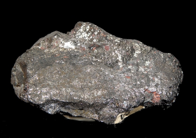


Silver King Mine, Park City Mining District, Summit County, Utah, USA