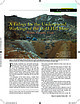
 | | Journal (article/letter/editorial) | | the Gold Hill Mine Downloaded by [Gazi University] at 11:25 09 January 2015 Tooele County, Utah PATRICK... The Gold Hill mine, with the 300-foot level’s tunnel to the left of the vehicles, the 150-foot level’s...tent, the 30-foot level above the 150-foot level (just below the ridge), and the 80-foot level’s dumps...underground workings of the Gold Hill mine in Tooele County, Utah. On 6 August 2007 the Utah Mined Land Reclamation...former mining and prospecting activity within the Gold Hill mining district, beginning with the Gold Hill |  | | Journal (issue) | | Famous mineral localities: the Gold Hill mine, Tooele County, Utah ................................... S. Wise The Wagon Wheel Gap fluorspar mine, Mineral County, Colorado ....................................33 by B. Cairncross The Jan Coetzee copper mine, Namaqualand, South Africa .......................right of amateur col lecting and recreational mining, and the use of public and private lands for educational...dark brown leather spine and black spine label with gold stamping. It is available in exchange for a $170 |  | | Report (issue) | | Director Professional Paper 177 THE GOLD HILL MINING DISTRICT U'TAH BY T. B. NOLAN UNItED STATES GOVERNMI£NT...sedimentary rocks in eastern Nevada and western Utah __________ _ Carboniferous system____ __ __ _ _...___ ___ _ __ ____ ___ ______ Clifton district _ _ __ History of mining and production__ ___ __ __ __...(Ida Lull) _ __ __________ Napoleon Mining Co_________ __ __ Gold Bond_ _____ ______ ___________ Copper...119 119 II Mines and prospects-Continued. Clifton district-Continued. Mines and prospects-Continued. |  | | Report (issue) | | ORE DEPOSITS OF THE SIERRITA MOUNTAINS, PIMA COUNTY, ARIZONA. By F. L. RANSOME. INTRODUCTION. The Sierrita...attains an altitude greater than 6,500 feet above sea level. Its slopes carry little or no timber, and in comparison...prospects within what is locally known as the Papago district, although they appear to be included within what...called the Sierritas district. On the east side of the range lies the Pima district, within which are a...near Twin Buttes, on the south; those near Mineral Hill, on the north; and those near the abandoned Olive |  | | Report (issue) | | Professional Paper Ill THE ORE ~DEPOSITS OF UTAH BY B. S. BUTLER, G. F. LOUGHLIN, V. C. HEIKES...81 83 84 84 85 87 87 87 87 THE ORE DEPOSITS OF UTAH. By B. S. BuTLER. PART !._:_GENERAL FEATURES. INTRODUCTION...INTRODUCTION. reports are those on the Mercur district, by J. E. Spurr and S. F. Emmons; the Bingham... began district, by J. M. Boutwell, Arthur Keith, and field work on the ore deposits of Utah in the S...S. F. Emmons; the Park City district, by J. M. FIELD .WORK AND AUTHORSHIP. summer of 1908 by making |  | | Journal (issue) | | ......... 15 W. E. Wilson The Piedmont mine, Yavapai County, Arizona ........................................ 29 B. L. Muntyan The San Manuel mine, Pinal County, Arizona ..................................Alexander The Morenci and Metcalf mines, . Gila County, Arizona ........................................& W. E. Wilson Mineral collecting at the Magma mine, . . Superior, Arizona ..........................Presmyk & M. Hay Treasures of the Magma mine, Pinal County, Arizona ............................... |  | | Report (issue) | | IRON DEPOSITS OF UTAH by Kenneth c. Bullock Geneva Works, U. S. Steel Corporation, near Provo. Courtesy...Courtesy of U. S. Steel Corporation . UTAH GEOLOGICAL AND MINERALOGICAL -SURVEY affiliated with THE COLLEGE...AND MINERAL INDUSTRIES University of Utah, Salt Lake City, Utah BULLETIN 88 PRICE $4.50 DECEMBER...· .1 History of the Iron Industry in Utah · .1 Beaver County . . . . . . . . . . . . .2 Beaver Lake... .2 . . . . . . . . . . .2 Black Rock mine . . . Skylark mine . . . . . . . . . . . . . . . . . . . |  | | Report (issue) | | MEXICO INSTITUTE OF MINING & TECHNOLOGY Mineral Deposits of Western Grant County, New Mexico by Elliot...Elliot Gillerman NEW MEXICO INSTITUTE OF MINING & TECHNOLOGY KENNETH W. FoRD, President NEW MEXICO BUREAU...PATRICIA E. CANDELARIA, Secretary JAMES M. ROBERTSON, Mining Geologist RoNALD J. RoMAN, Chief Research Metallurgist... . . 7 Climate and vegetation 8 HISTORY OF MINING 9 Production . . . . . . . . . . . . . . . ..... . . . . . . . . . . . . . . . . 37 Tyrone district . . . . . . . . . . . . . . . . . . . . . . . |  | | Report (issue) | | - Wyoming gold. Gold buttons in the prospector's pan were recovered by Dean Farris from mine dump waste...waste in the Gold Hill district. The actual diameter of the button in the lower left is approximately '...',4 inch. (Gold photographed by Alan J. VerPloeg; drawing by Phyllis A. Ranz.) THE GEOLOGICAL SURVEY... . . . . . . . . . . . . . . . . . . . Kirwin district . . . . . . , . . . . . . . . . . . . . . . ....City) district .. . . . . . . . . . . . . . . . . . . . . . . . . 13 16 Stinkingwater district . . |  | | Report (volume) | | FRANK C. SCHRADER WITH CONTRIBUTIONS BY JAMES M. HILL WASHINGTON GOVERNMENT FEINTING OFFICE 1915 sas-aa^1^...17 Climate and vegetation. 18 _._ History of mining and present conditions___________________ 20 ..._______________ . Placers __ _ Mineralogy ____________ Mining districts, camps, and properties. Helvetia district_..._______________ _____ Ore deposits _ . Copper World mine ____ _____ _____ Location and topography _ _ History..._____ Black Horse mine _ Leader mine_ '. Isle Royal mine Heavy Weight mine Old Dick mine _______________ |  | | Report (issue) | | '1030571 04 M030562 04 M030563 04 '1030584 04 CouNTY DEPosir 'ostHP +litire LAtiroOE ♦ Looroae 28N... wA A 7 PROSPECT 15N 02E 27 MU AMOLE DISTRICT BANNER DISTRICT BLUE HELL GROUP 19N 215W 101 35-03-A wA...CUA AG BORIANA MINE 18N 115W 118 34-56-154 113-54-53W CATALINA DISTRICT CATALINA DISTRICT CHILDS-ALOWINKLE...CHILDS-ALOWINKLE HUN CINNABAR MINE 02N I14-19-18w 09 33-32-154A CUPRITE MINI 175 16E 28 31-55-314 110-42-30w CU AG...35 35-25-254 114-10-31W AU AG MO V EMPIRE MINE ESPERANZA MINE GROUP 185 12E SO.31-52-204 111-08-08W PB |  | | Report (issue) | | organization is carrying on for the direct advancement of mining interests throughout the country than can readily...occurring in area of folio. Iddings, J. P.; Weed, Gold, copper, clays, lime W.H. stone, coal. Hayes, C...products described as occurring i:i area of folio. Gold, copper, chromite, iron, coal, stone, lime, clay..... Coal, iron, lime, stone, road metal, clay. Gold. Haycs, C. W......... Coal, iron, lime, stone, road...metal, clay. Emmons, S. F.; Cross, Coal, silver, gold, stone, W.; Eldriclgc, G.H. lime, clay. Keith, A |  | | Book (edition) | | Chapters on the Coeur d'Alene Mining District, the Blackbird Mining District, and the Sawtooth Mountains...Chapters on the Coeur d'Alene Mining District and the Blackbird Mining District, and to Ben Sheppard for reviewing...reviewing the chapter on the Blackbird Mining District. Those who contributed photographs, or specimens...or a vein of massive pyrite and chalcopyrite in a mine, so references such as these were not included....for a particular mineral may be a certain mine, but that mine may now have a new name, or may now be a |  | | Journal (issue) | | 1980 ARIZONA! Articles The Hamburg mine and vicinity, Yuma County, Arizona by D. M. Shannon Famous mineral...mineral localities: the Red Cloud mine, Yuma County, Arizona............................................ ARIZONA-1 COVER: WULFENITE from the Red Cloud mine (see p. 141). This crystal, 5 cm across and nearly...Multiple Japan-law quartz twins from the Yankee Boy mine (1, 7, 33), by Richard A. Bideaux. Three specimens...an outcrop near the White Tail Deer mine in the Bisbee district. Wickenburgite (1,2, 80), by Sidney A |  | | Report (issue) | | 3i University of Nevada Press, Reno, Nevada 89557 USA Copyright© 2004 by Uni versity of Nevada Press Photographs...te, r.6-cm cluster, Majuba Hill Mine, Antelope district, Pershing County. N. Prenn coJlection. Photograph...percent of the state. Nevada's public lands offer mining, livestock grazing, wild horse viewing, .scenic...Road and Geologic Tours in th<' Las Vegas Area. Mining and the discovery, identification, and development...PART IV PART II MINERAL DEPOSITS Carlin-1:,. pe Gold Depo!:>its (Jresor}' c. Nevada Mineral Catalog |  | | Journal (volume) | | 4000 Salt Lake 3VHA مم • THE JOHNNIE MINING & MILLING COMPANY. - Illustrated . E rn lectre...lectre cel 2 Weste THE CROWN POINT GLOBE MINING COMPANY . - Illustrated .. سر/ SerT 19 CE W E VI ...11 , No. 1 000ook 1st. 1899. SALT LAKE CITY, UTAH, APRIL 15, 1909 11 SINGLE COPY, 15 CENTS 10 Association...GOES ON FOREVER The Mine & Smelter Supply Co. SALT LAKE CITY , UTAH 2. THE MINING REVIEW , SALT LAKE...LAKE CITY , UTAH , APRIL 15 , 1909 . Alamo Gasoline Hoists ed IN the latter part of 1908 the |  | | Report (issue) | | of the Thomas and Dugway Ranges Juab and Tooele Counties Utah By MORTIMER H. STAATZ and WILFRED J. CARR...of Silurian age____________________________ Bell Hill dolomite (Middle Silurian) _____ -·-____ Harrisite...Confidence ____________________________ _ Four Metals mine ______________________ _ Francis _______________________________...__________________ _ Page 148 148 148 149 149 150 151 151 151 152 153 154 157 157 158 160 160 160 ...1. Geologic map of the Thomas and Dugway Ranges, Utah. 2. 3. 4. 5. 6. 7. 8. 9. 1. 2. 3. Geologic sections |  | | Report (volume) | | Bulletin 648 NOTES ON SOME MINING DISTRICTS IN EASTERN NEVADA BY JAMES M. HILL WASHINGTON GOVERNMENT PRINTING.................................................. Gold veins.............................................Clark County.......................................................'.. Gold Butte mining district.................... Lincoln mine........................................ Bennett mine.........................granite and gneiss............................. Gold Butte Mining Co................................. New Era |  | | Report (issue) | | CIRCULAR 10 THE McCOY MINING DISTRICT AND GOLD VEINS IN HORSE CANYON LANDER COUNTY, NEVADA Papers by F...CIRCULAR 10 THE McCOY MINING DISTRICT AND GOLD VEINS IN HORSE CANYON LANDER COUNTY, NEVADA Papers by F...Washington 1934 F'7V6 Contents Page The McCoy mining district Introduction Location and topography Geology...Outlook Mines and prospects Gold Dome mine nig Four mine McCoy Consolidated mine McCoy-Strong lease Dewitt...lease Three M lease Childcr prospect Other prospects Gold veins in Horse Canyon Introduction General geology |  | | Report (issue) | | Director G. H. RQSEVEARE, Metallurgist G. R. FANSETT, Mining/Engineer ELDRED ,D. WILSON, Geologist 'J.W. ANTHONY...13 13 13 14 15 17 CHAPTER n.-BISBEE OR WARREN DISTRICT. By Wm. G. Hogue and Eldred D. Wilson................................ History of Lead and Zinc Mining..................................................Eastern Part of District ........................ Lead and Zinc in Western Part of District................29 29 29 CHAPTER nI.-JOHNSON CAMP AREA, COCHISE COUNTY, ARIZONA. By John R. Cooper .................. |  | | Report (issue) | | ...... ·- ......... . J,5 Historical sketch of mining and smelting in New Mexico....... . . . . . . ....... : . .............. - ........ .. . . T~os County, by L. C. Graton and W ..Lindgren ..... ................. . . , ... -.. . Rio Hondo. (Twining) district . . . . . . . . . . . . . ......................::.:::.::: ::: :::: :: ':::: :: ::::. Red River district. ..................•......... -~ . . ...........·::-; : : :. ::.·.i?:5.•.:...,. .... Black.Copper mine ........ ............. ~ ... .. . .... ·....... |  | | Report (volume) | | GEOLOGY AND OEE DEPOSITS OF THE MOGOLLON MINING DISTRICT, NEW MEXICO BY HENRY G. FERGUSON WASHINGTON...and prospects.-___ ______ _________________ Eureka mine _ _ ____ ________________ Veins of the Pacific ...groups__,____________ Gold Dust mine_____________________________ Veins between Gold Dust and Last Chance...Chance veins_________ Deadwood mine __________________ __________ Last Chance mine_____________________________...mine_ _ _ _ _ _ _ Cooney mine ____ _ _ _ _ ___ Prospects northwest of the Cooney mine- _ _ __r ___ Veins |  | | Book (edition) | | who have been engaged in the study of our great mining regions, especially in the West, have laid the...now in the active practice of the profession of mining engi neering. J. F. K. DECEMBER, 1899. NO TEXT...125-129; Marquette district, 129-136; Menominee dis trict, 136-139; Penokee-Gogebic district, 139-143; Vermilion...Vermilion Lake and range, 144-150; Mesabi, 150-154; Example 10, James River, Va., 154, 155; Example 11,... Cornwall, Pa., 175-180; Example 14a, Iron Co., Utah, 180; Example 15, magnetite sands, 180. 181 ; origin |  | | Journal (volume) | | 1915 The Salt Lake Mining Review 1601 Walker Bank Building SALT LAKE CITY , UTAH 2 620.05 SI V.16...13 , 1914 , Page Interest Operations on Kramer Hill . By Will C. Higgins 15 17 Recent Progress at...Tunnel .: By Murray Schick . 18 19 Pack Creek , Utah , Has Large, Rich Carnotite Deposits . Silver King... Editorial Make the Prospect Pay. Editorial The Utah Products Show The Prospector and His Burro . By:...1914. The Utah Consolidated Stone Co. The Nevada . : Items : The Cameron Coal Mines , Utah Detail Costs |  | | Report (issue) | | advance publication] Page (A) The Contact mining district, Nev., by Frank C. Schrader (B) The Rosebud...mineral resources of north-central Chouteau, western Hill, and eastern Liberty Counties, Mont., by W. G. Pierce...ILLUSTEATIONS PLATE!. The western part of the Contact district, Nev., looking northwest from the foothills east...2. Geologic reconnaissance map of the Contact district-___ 3. Claim map of the Contact district_________________...looking west across plateau surface of Liberty County toward Sweetgrass Hills__________..______________ |
|
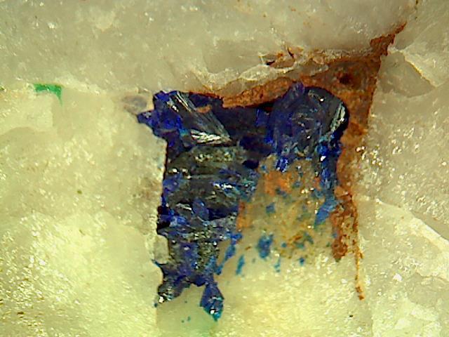


150 foot level, Gold Hill Mine, Gold Hill, Gold Hill Mining District, Tooele County, Utah, USA