| Locality type: | Fissure |
| Classification |
|---|
|
| Species: | Alumoklyuchevskite |
| Formula: | K3Cu3(Al,Fe3+)(SO4)4O2 |
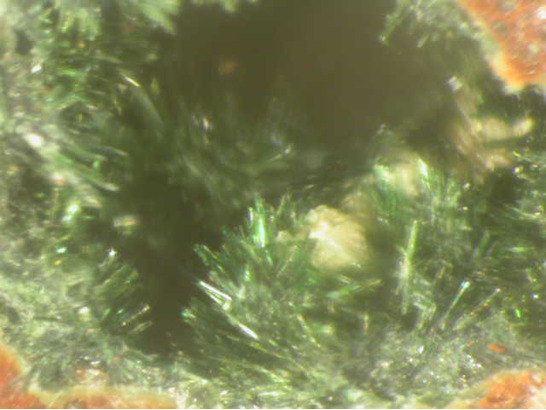
| Comments: | From thesecond cone of the Northern Breakthrough.
Alumoklyuchevskite occurs as aggregates of dark green acicular crystals, elongate <010>, to 1 mm length and <0.1 mm width. Almost equant in cross-section, transparent,…Turns white on exposure to air, probably by hydration. |
| Confirmation |
|---|
|
| Validity: | Valid - Type Locality |
| Associated Minerals Based on Photo Data: |
|---|
|
| Euchlorine | ⓘ2 photos of Alumoklyuchevskite associated with Euchlorine at this locality. |
| Lyonsite | ⓘ1 photo of Alumoklyuchevskite associated with Lyonsite at this locality. |
| Data |
|---|
|
| Mineral Data: | Click here to view Alumoklyuchevskite data |
| Locality Data: | Click here to view Great Fissure eruption (Main Fracture), Tolbachik Volcanic field, Milkovsky District, Kamchatka Krai, Russia |
| Photo Gallery | View Gallery (2 photos) |
| Data Identifiers |
|---|
|
| Mindat Occurrence Record ID: | 19558 |
| Long-form Identifier: | 1:3:19558:4 |
| GUID (UUID V4): | 4e5d1528-8982-4e32-a6e9-08c31096df82 |
| Localities for Alumoklyuchevskite in this Region |
|---|
|
| Second scoria cone, Northern Breakthrough (North Breach), Great Fissure eruption (Main Fracture), Tolbachik Volcanic field, Milkovsky District, Kamchatka Krai, Russia |
| Arsenatnaya fumarole, Second scoria cone, Northern Breakthrough (North Breach), Great Fissure eruption (Main Fracture), Tolbachik Volcanic field, Milkovsky District, Kamchatka Krai, Russia |
| Glavnaya Tenoritovaya fumarole (Major Tenorite), Second scoria cone, Northern Breakthrough (North Breach), Great Fissure eruption (Main Fracture), Tolbachik Volcanic field, Milkovsky District, Kamchatka Krai, Russia |
| Yadovitaya fumarole, Second scoria cone, Northern Breakthrough (North Breach), Great Fissure eruption (Main Fracture), Tolbachik Volcanic field, Milkovsky District, Kamchatka Krai, Russia |
| Nearest other occurrences of Alumoklyuchevskite |
|---|
|
|
| 0.0km (0.0 miles) | ⓘYadovitaya fumarole, Second scoria cone, Northern Breakthrough (North Breach), Great Fissure eruption (Main Fracture), Tolbachik Volcanic field, Milkovsky District, Kamchatka Krai, Russia |
| 17.1km (10.6 miles) | ⓘSecond scoria cone, Northern Breakthrough (North Breach), Great Fissure eruption (Main Fracture), Tolbachik Volcanic field, Milkovsky District, Kamchatka Krai, Russia |
| 17.8km (11.1 miles) | ⓘGlavnaya Tenoritovaya fumarole (Major Tenorite), Second scoria cone, Northern Breakthrough (North Breach), Great Fissure eruption (Main Fracture), Tolbachik Volcanic field, Milkovsky District, Kamchatka Krai, Russia |
| 17.8km (11.1 miles) | ⓘArsenatnaya fumarole, Second scoria cone, Northern Breakthrough (North Breach), Great Fissure eruption (Main Fracture), Tolbachik Volcanic field, Milkovsky District, Kamchatka Krai, Russia |
| References |
|---|
|
Gorskaya, M.G., Vergasova, L.P., Filatov, S.K., Rolich, D.V., Ananiev, V.V. (1995) Alumoklyuchevskite, K3Cu3AlO2(SO4)4, a new oxysulfate of K, Cu, and Al from volcanic exhalations, Kamchatka, Russia. Zapiski Vserossijskogo Mineralogicheskogo Obshchestva: 124: 95-100. |


Yadovitaya fumarole, Second scoria cone, Northern Breakthrough, Great Fissure eruption, Tolbachik Volcanic field, Milkovsky District, Kamchatka Krai, Russia