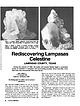
 | | Journal (article/letter/editorial) | | cm across. Rediscovering Lampasas LAMPASAS COUNTY, TEXAS During the summer of 1989, the author and several...REGION SURROUNDING the city of Lampasas, Texas (and the county of the same name), has long been recognized...and unique coloration of celestine from around Austin (70 miles southeast of Lampasas), where frequent...Geographically, Lampasas is located in that part of central Texas commonly known as the “Hill Country,” a sprawling...Antonio. Considered in this article are Lampasas County and portions of the nearby counties of Brown, Mills |  | | Journal (article/letter/editorial) | | at 13:58 04 February 2015 Maybee Quarry, Monroe County, Michigan C elestine, the only commercially significant...variety of minerals, including strontianite, gypsum, calcite, dolomite, fluorite, and sulfur; clastic rock units...gypsum and as casts after halite and calcite are known, as are calcite, quartz, barite, and sulfur pseudomorphs... Michigan Stone Company quarry, Maybee, Monroe County, Michigan. Unusual celestine and associated sulfur...associated with brown fluorite from Clay Center, Ottawa County, Ohio, grace most museum collections. Other noteworthy |  | | Journal (article/letter/editorial) | | Texas mineral locality INDEX Whereas Texas is well known for its vastness, cattle industry, and oil...I T S T O P O G R A P H Y A N D G E O L O G Y , Texas, the second largest state, has produced relatively...famous localities. A s this article will show, Texas has had—or currently has—nu merous mineral occurrences...produce good specimens; yet when specimens from Texas are sought in collections and dealers' stocks, few...some basic facts that help explain the situation. Texas has very little federal land in its mineralized |  | | Report (issue) | | its hardness from 3 to 3£, being about that of calcite. Strontianite, the carbonate of strontium, commonly...together. In the vicinity of Schoharie, Schoharie County, N. Y., the minerals have been found in a rather...rocks of the Clinton formation near Clinton, Oneida County, N. Y., associated with celestite in geodes. The...and on the shore of Chaumont Bay, in Jefferson County, N. Y. In the town of Adams, about 2 miles from...from the village of Adams Center, in Jefferson County, a vein of celestite is known to occur in the Trenton |  | | Report (issue) | | BIBLIOGRAPHY OF THE EDWARDS AQUIFER, TEXAS, THROUGH 1993 Compiled by Julie A. Menard U.S. GEOLOGICAL...RESEARCH IN WATER RESOURCES, UNIVERSITY OF TEXAS AT AUSTIN Austin, Texas 1995 U.S. DEPARTMENT OF THE INTERIOR...District Chief U.S. Geological Survey 8011 Cameron Rd. Austin, TX 78754-3898 U.S. Geological Survey Earth Science...1. Map showing location of the Edwards aquifer, Texas TABLE 1. List of bibliographic data bases searched...kilometer Bibliography of the Edwards Aquifer, Texas, Through 1993 Compiled'byr Julie A. Menard Abstract |  | | Report (issue) | | limestone. The associa,ted mineral is chiefly calcite. Only tra c,e8 of zinc-blende a,nd cha,loopyrite...Lo11ghborough in Frontenac .·county, and in the township of J~c111sdowne, Leeds County, Onta.rioJ lJut tl1ese...wo1..ketl jn the States of Califon1ia1, A1izona., Texas a,nd a,shington . In Cr1;lifo1~nia., celestite ...1916 from a depc)sit on tl1e 1·1nperial San Diego, County line, a1bout 3] mileA west <>f Bra,vvley, on the...serpentine a mile south-west o,f La Conner, Skagit County. TJ1e strontianite is "'hite and finely crystalline |  | | Report (issue) | | ECONOMICGEOLOGY The University of Texasat Austin Austin, Texas 78712 JOHN T. LONSDALE, Director Report...Report of Investigations — No. 42 Texas Gemstones By Elbert A. King, Jr. February 1961 — — February...OFECONOMIC GEOLOGY The University of Texas at Austin Austin, Texas 78712 JOHN T. LONSDALE, Director —...— No. 42 Report of Investigations Texas Gemstones By Elbert A. King, Jr. February 1961 — — — Second...gemstones Cabochon gems Faceted gems Tumbled gems Texas gemstones Amber Augite Beryl Celestite Diamond Epidote |  | | Report (issue) | | presence of such impurities as silica, gyps11rn, calcite, barium sulphate, clay and iron oxide. N. Collie*...concretionary, and is associated with a little calcite in a nearly vertical vein, some 4 ft. wide, traversing...township of Bagot, Renfrew County; (2) the township of Fitzroy, Carleton County; (3) the township of Lansdowne...Lansdowne, Leeds County; and (4) Loughborol1gh township, Frontenac County. The three known occuITences...are located in the township of Nepean, Carleton County, Ontarjo; in the Cariboo district, British Columbia; |  | | Report (issue) | | serve the Bureau, the University, the State of Texas, and the nation these past 19 years. Before embarking...design and modeling; and the new seismic network for Texas, TexNet , which provides a catalog of earthquakes...phone at 512-471-1534. The Rio Grande in far West Texas on its way to the Gulf of Mexico; the view at Boquillas...the state-funded network of seismometers across Texas that conducts research into earthquake causation...Environmental Engineering. Researchers at SMU, Texas A&M, the University of Houston, UT Dallas, and UT |  | | Report (issue) | | INSERTS Correlation of the Comanche deposits of Texas and nearby States ................................sections in the Edwards Plateau and in trans-Pecos Texas are included to show the stratigraphic occurrence...age of the Devils River limestone of southwestern Texas. INTRODUCTION This study of the Comanche faunas...and T. W. Stanton in Kansas, Oklahoma, Arkansas, Texas, New Mexico, and Arizona, and in the Rio Grande...Frank, 1895, in north central Texas. Cragin, F. W., about 1885 to 1897, in Texas and Kansas. Cummins, W. F |  | | Book | | HARRIS COUNTY PUBLIC LIBRARY EOLOGY of TEXAS Darwin Spearing KW 3 4028 05687 8482 HARRIS COUNTY PUBLIC...only APR 0 9 1997 ?//f(ff ROADSIDE feOLOGY of Texas Darwin Spearing MOUNTAIN PRESS PUBLISHING COMPANY...ion Data Spearing, Darwin. Roadside geology of Texas / Darwin Spearing. p. cm. — (Roadside geology series...series.) Rev. ed. of: Roaside geology of Texas / Robert A. Sheldon. 1979 Includes bibliographical references...index. ISBN 0-87842-265-X 1. Geology Texas Guide-books. 2. Texas—Description and travel 1981 Guide-books |  | | Report (issue) | | stratigraphy interpreted in Midland Basin of West Texas Permian tight-oil resource play. Different colors...McCall 512-471-0320, linda.mccall@beg.utexas.edu Austin Core Research Center Nathan Ivicic 512-475-9561...Research Campus 10100 Burnet Road, Bldg. 130 Austin, Texas 78758-4445 512-471-1534, Switchboard; 512-471-0140...Address The University of Texas at Austin PO Box X, University Station Austin, Texas 78713-8924 Message...to a rock outcrop somewhere in the vast State of Texas to physically sample and analyze what might be a |  | | Report (issue) | | in 1909 as the successor to the Texas Geological Survey and the Texas Mineral Survey, is a research entity...entity of The University of Texas at Austin. It also functions as the State Geological Survey, a quasi-State...quasi-State agency, and the Bureau Director represents Texas in the Association of American State Geologists...services relating to the resources and geology of Texas are provided by the Bureau. In addition, the Bureau...as with State, Federal, and local agencies. The Texas Mining and Mineral Resources Research Institute |  | | Report (volume) | | PRESENT CONDITION OF KNOWLEDGE OF THE GEOLOGY OF TEXAS P.Y ROBERT T. HILL WASHINGTON GOVERNMENT PRINTING....... 15 15 18 21 22 23 24 25 25 26 27 27 The Texas land office ..............................!^............... 49 Classification of topography of Texas ................................... 52 Chart illustrating................. Table of geologic formations of Texas, with authorities.................. So-called Archean.............. General conclusions respecting the Texas Carboniferous....:......... So-called Permian or |  | | Report (volume) | | minerals of wide distribution, such as quartz and calcite, have been omitted, except those that by some unusual...Ashley, Washington, D. C. Texas............Dr. William B. Phillips, Austin. Vermont..........Prof. George...See Bauxite and Hallpysite. Asbestos. Tallapoosa County, with corundum deposits near Dudleyville; not found...commercial quantity or quality. Asphalt. Colbert County, small quantity has been shipped from near Leighton;...following localities: Bibb County, Pratts Ferry; Calhoun County, near Tampa; Clay County, T. 20, Pv. 7 E.; Jefferson |  | | Report (volume) | | 248 259 269 271 275 281 r 4 CONTENTS. Page. Texas...................................................that are widely distributed, such as quartz and calcite, have been omitted, except those that by reason...New Mexico, Oregon, South Dakota, Tennessee, and Texas; to list all the literature consulted would be impracticable...Phillips, W. B., The mineral resources of Texas: Univ. Texas Bull. 365, Sci. Ser. 29, 1914. Among other...Purdue, Nashville. Texas______.Dr. W. B. Phillips, Austin. Utah______.Mr. G. W. Ritter, Salt Lake City. Mr |  | | Book | | Internet Archive in 2022 with funding from Kahle/Austin Foundation https://archive.org/details/howtoknowmineral0000pear...collector may specialize in a single mineral—perhaps calcite, which comes in more than 300 dif- ferent crystal...Death Valley, or New England) or from your home county; minerals of your favorite color; minerals that...flaked into Christmas-tree “snow”; sulfur from Texas to make possible the heavy- chemical industry...collector will probably not come into the fortune of a Texas oilman or of Dr. Williamson, the African diamond |  | | Book | | commercial ores and secondary minerals by state, county, township, and geologic range. For easy identification...Internet Archive in 2017 with funding from Kahle/Austin Foundation https://archive.org/details/rangeguidetomineOOrans...cities, and many of today’s prosperous western county seats began as mining-boom camps. trating sand...Whether you such as those listed alphabetically by county, township, and range in Part II of this book. Where...intrusives Dark minerals, Limestone quarries Calcite, celestite, dolomite, fluorite, galena, sal ammoniac |  | | Book (volume) | | Internet Archive in 2022 with funding from Kahle/Austin Foundation https://archive.org/details/gemstonesofnorthO001...the Southern Gem and Mineral Company of El Paso, Texas. Information on the Virgin Valley opal deposits...furnished information and a photograph on the calcite onyx deposits of Baja California. Owen H. Perry...L. Mahaffey of Nevada, Missouri. The well-known Texas agate localities of the Alpine Region were described...Kobuk jade locality. Descriptions of San Diego County, California, gemstones and the mines in which they |  | | Report (volume) | | Umpleby.... The Yellow Pine mining district, Clark County, Nev., by J. M. Hill...... Survey publications...sulphate in the Carrizo Plain, San Luis Obispo County, Cal., by U.S. Gale............................................. 428 Borate deposits in Ventura County, Cal., by H. S. Gale.................. 434 Potash...SULPHUR AND PYKITE : < Sulphur deposits in Park County, Wyo., by D. F. Hewett............... 477 Survey...Sketch map of the Yellow Pine mining district, Clark County, Nev.. V. Map showing relation of outcrops of red |  | | Report (volume) | | Bull. 1060-D, p. 193, 252-253, pl. 7. In Nemaha County, Kans., member is basal unit of Howard limestone...Aarde farm, sec. 4, T. 26 S., R. 11 E., Greenwood County. Aaron Slatet Precambrian or Paleozoic: Central...Central Railroad, sees. 5-7, T. 11 S., R. 5 E., Pope County. Named for Abbott Station. Abbyville Gabbrol Precambrian...map. Occurs in vicinity of Abbyville, Mecklenburg County. Abercrombie Formationl Middle Cambrian: Western...above Pope Creek coal. Named for Aberdeen, Butler County, Ky., where it stands out in prominent cliffs along |  | | Report (volume) | | 5 in., inch or inches. Circ., Circular. Co., County or Company. Indus., Industrial. Inst., Institute...Pre-Cambrian : Central southern Virginia (Mecklenburg County). F. B. Laney, 1917 (Va. Geol. Surv. Bull. 14,...formation. Permian : Central and central northern Texas. W. E. Wrather, 1917 (SW. Ass. Pet. Geol. Bull....exposures in Abrigo Canyon, 3 mi. SW. of Bisbee. In Mount Martin section upper limit of Abrigo fm. is defined...Pleistocene : Southern South Carolina (Charleston County). E. Sloan, 190 (S. C. Geol. Surv. geognostic map |  | Palache, Charles, Berman, Harry, Frondel, Clifford (1951) The System of Mineralogy (7th ed.) Vol. 2 - Halides, Nitrates, Borates, Carbonates, Sulfates, Phosphates, Arsenates, Tungstates, Molybdates, Ect. John Wiley and Sons, New York. | Book (volume) | | certain common and important series such as the calcite group. At the same time, the separate descriptions...Verde Valley, Yavapai County, Arizona. In Nevada along the Virgin River in Clark County, and in distorted...distorted crystals from Humboldt County. From Borax Lake, San Bernardino County, California. In the Permian basin...of southeastern New Mexico and adjacent parts of Texas. Obtained from the waters of Great Salt Lake, Utah...Found at several mines in the Huantajaya district, calcite, embolite, cerargyrite, bromyrite, iodyrite, atacamite |  | | Book (edition) | | relative degrees. Mohs’ Scale 1. Talc 2. Gypsum 3. Calcite 4. Fluorite 5. Apatite 6. Feldspar 7. Quartz 8...forms a very small industry at Brandon in Suffolk County. Grindstones and Pulpstones. The production of...sandstone may be cemented with quartz, calcite, clay, or Hmonite. Calcite may be objectionable due to its solubility...firinding lOl,583 pebbles were |>rTexas, Washington, and Wisconsin. Short tons Value ...principally in the vicinity of Hot Springs, Garland County, are of two varieties: Arkansas stone, which is |  | | Book (edition) | | Internet Archive in 2022 with funding from Kahle/Austin Foundation httos://archive.org/details/mineralogyforama000O0sink...the out- standing shows of the annual San Diego County Fair at Del Mar, California. In addition, the collections...purposes, each behaves like a single-atom ion. Calcite furnishes the prime example of a mineral containing...schematically at the bottom of Figure 8. Although calcite is composed of three elements, namely calcium,...bonding is shown by what happens to the radical when calcite dissolves in water to later form stalactites and |
|


Mount Bonnell, Austin, Travis County, Texas, USA