| Locality type: | Deposit |
| Classification |
|---|
|
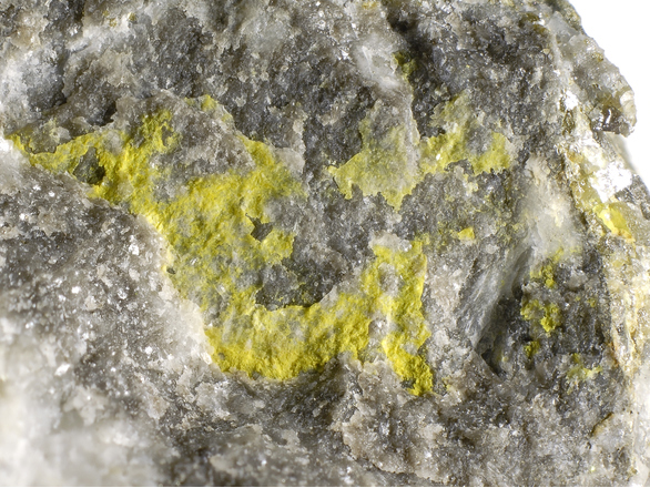
| Species: | Greenockite |
| Formula: | CdS |
| Confirmation |
|---|
|
| Validity: | Believed Valid |
| Data |
|---|
|
| Mineral Data: | Click here to view Greenockite data |
| Locality Data: | Click here to view Jaukenhöhe, Dellach, Hermagor District, Carinthia, Austria |
| Data Identifiers |
|---|
|
| Mindat Occurrence Record ID: | 203547 |
| Long-form Identifier: | 1:3:203547:5 |
| GUID (UUID V4): | 50f250b7-3c13-4904-85b4-bf2bac0adb80 |
| Nearest other occurrences of Greenockite |
|---|
|
|
| 31.2km (19.4 miles) | ⓘZuchengraben (Suchengraben; Zauchengraben; Zuchen), Graslitzen (Gradlitzen; Palascha), Förolach, Hermagor-Pressegger See, Hermagor District, Carinthia, Austria |
| 33.4km (20.8 miles) | ⓘMitterberg, Kreuzen, Paternion, Villach-Land District, Carinthia, Austria |
| 36.6km (22.7 miles) | ⓘSchliwagraben (Matschiedler Alpe; Matschiedleralpe), Windische Höhe, Sankt Stefan im Gailtal, Hermagor District, Carinthia, Austria |
| 38.2km (23.7 miles) | ⓘUntere Pazisel (Parzissel), Große Zirknitz valley, Zirknitz, Großkirchheim, Spittal an der Drau District, Carinthia, Austria |
| 39.9km (24.8 miles) | ⓘAugustin adit, Rauriser Goldberg, Kolm-Saigurn, Alteck - Hoher Sonnblick area, Rauris, Zell am See District, Salzburg, Austria |
| 43.9km (27.3 miles) | ⓘMax Mine, Bleiberg-Kreuth, Bad Bleiberg, Villach-Land District, Carinthia, Austria |
| 44.1km (27.4 miles) | ⓘBleiberg-Kreuth, Bad Bleiberg, Villach-Land District, Carinthia, Austria |
| 48.1km (29.9 miles) | ⓘKölnbreinkar, Kölnbreinspitze - Lausnock area, Malta, Spittal an der Drau District, Carinthia, Austria |
| 48.1km (29.9 miles) | ⓘRaibl Mines, Cave del Predil, Tarvisio, Udine Province, Friuli Venezia Giulia, Italy |
| 48.2km (29.9 miles) | ⓘFriedrich adit (healing tunnel), Bad Bleiberg, Villach-Land District, Carinthia, Austria |
| References |
|---|
|
|


Jaukenhöhe, Dellach, Hermagor District, Carinthia, Austria