 | | Report (issue) | | DESCRIPTIVE MINERALOGY OF PENNSYLVANIA 104 Na 2Al 2 Si3 Oi .2H 2 O; SiO 2 47.4, A1 2 O 3 26.8, Na...Na 2 O 16.3, Lenni, Delaware County. Crystals. Eyerman, 1911, 11. Composition: Analysis: Fe 2 O3 CaO...Sp.gr LOCALITIES: Berks County: Birdsboro, and Gickerville; Delaware County: Leiperville, Lenni (druses... Felton's farm (Chester), and Ward's quarry; Montgomery County: Sumneytown, and Perkiomenville ; Philadelphia:...Philadelphia: Fairmount Park, Frankford, and Rit- enhouse quarry. SCOLECITE CaAl 2 Si3 Oi .3H 2 O MONOCLINIC |  | | Report (volume) | | RESOURCES OF THE QUAKERTOWN-DOYLESTOWN DISTRICT PENNSYLVANIA AND NEW JERSEY BY F. BASCOM, E. T. WHERRY,...t corner of the area______-___-__-___-__-_--___ East of Doylestown___________________________________...exfoliation, Philadelphia & Reading Railway cut at Rock Hill, Quakertown quadrangle; B, Cryptozoon proliferum...Well-bedded shales of the Lockatong formation in quarry on Delaware River 1 mile west of Lumberville, Doylestown...near Holicong, Doylestown quadrangle; C, Kettle Rock, a large hole resembling a pothole formed in hard |  | | Report (issue) | | PENNSYLVANIA GEOLOGICAL SURVEY FOURTH SERIES BULLETIN M 15 BUILDING STONES OF PENNSYLVANIA By RALPH... COPYRIGHTED 1932 BY THE COMMONWEALTH OF PENNSYLVANIA ADDITIONAL COPIES OF THIS PUBLICATION BUREAU...Structure 3 •> 10 Strength 10 Geology of Pennsylvania Physiography Stratigraphy Appalachian Revolut...Adams County Allegheny County Armstrong County Beaver County 19 1" -<» -- 24 -7 Bedford County -'•'...-;"» SO Perks County ;>- Blair County Bradford County Pucks County Butler County 00 03 07 77 Cambria |  | | Report (volume) | | of M assachusetts, Connecticut, New jersey, Pennsylvania, Virginia , Maryland , North Carolina, and other...geology of Massachusetts, Connecticut, New Jersey, Pennsylvania, Virginia, Maryland , North Carolina, and South...[radiometric age]* Barite [economic geology]* Basalt [rock type]* Bedrock geology Bibliography* Buried basins*...[economic geology]* Copper [economic geology]* Diabase [rock type]* Economic geology [accompanied by commodity...[usually accompanied by rock type]* Geophysics* Gold [economic geology]* Granophyre [rock type] Gravity [geophysics]* |  | | Report (volume) | | THE HONEYBKOOK AND PHOENIXVILLE QUADBANGLES, PENNSYLVANIA BY F. BASCOM AND G. W. STOSE UNITED STATES...58 59 59 59 65 65 65 67 67 68 71 73 76 Cenozoic rock.____________________________________________ 78...Pa_ ________ In pocket 2. A., Thomas Hill viewed from the east; B, Lamellar injection of gabbro by ...3. Reconnaissance geologic map of Chester Valley east of Phoenixville quadrangle. _____________________________________...quadrangles___-___---_-_-__ 7. Map of southeastern Pennsylvania showing relation of Honeybrook uplift to South |  | | Report (volume) | | ........................................... Pennsylvania...............................................about 1,250,000 barrels. The production of natural rock cement was five times the combined production and...than 86,000,000 barrels. The production of natural rock cement and the imports of foreign cement are so...value. Some minerals, such as the copper ores of Pennsylvania, are included in the list not because they occur...Compendium of the mineral resources of Arkansas, Little Rock Board of Trade Bulletin, 1912. Eakle, A. S., Minerals |  | | Report (volume) | | about 1,250,000 barrels. The production of natural rock cement was five tunes the combined production and...than 80,000,000 barrels. The production of natural rock cement and the imports of foreign cement are so...value. Some minerals, such as the copper ores of Pennsylvania, are included in the list not because they occur...North Carolina.. .Dr. Joseph Hyde Pratt, Chapel Hill. North Dakota... .Dr. A. G. Leonard, Grand Forks...Oregon............Prof. A. J. Collier, Eugene. Pennsylvania.... .Mr. R. R. Hice, Beaver. Prof. Florence |  | | Report (issue) | | Site Number, Site Name ...................... 6 County, State, Quadrangle, Latitude, Longitude .........Occurrences located in the Newark basin and vicinity, Pennsylvania ..................... 110 F. Section F: Occurrences...located in the Gettysburg basin and vicinity, Pennsylvania ..................... 147 G. Section G: Occurrences...occurrence, deposit mineralogy and paragenesis, host rock lithology and age, and metal associations is presented...given in the categories of : 1. name and location ( county, state, quadrangle, latitude, and longitude) 2 |  | | Report (issue) | | of Highway No. 61: and to the county engineer's office of Lake County at Two Harbors for various materials...Conservation Corps, as well as a special survey of the east branch of the Baptism River, were furnished by officials...R. B. Ellestad of the University of l\Iinnesota Rock Analysis Laborator~·. F.F.G. G.M.S. III CONTENTS................... , .. . 32 The Red Granite (Red Rock) and Rocks Intermediate between Red Granite and.... . . . . . . . . . . . .. Township Township Township Township Township 54 55 55 56 56 North. North |  | | Journal (article/letter/editorial) | | of the State Capitol Building recently (in Little Rock, Ark.), where I found on display some very fine..."The locality is the Jeffrey quarry located 1/2 mile outside North Little Rock city limits on State Hwy 65...65 in Pulaski County, Ark." — letter dated July 31, 1963 from Richard Purifoy, 2101 Orange St., North...North Little Rock, Ark. "I have fine xline siderite and red and brown bauxite in almost any desired size...field trip. Actually it was a get-away-from-it-all, rock-hunting, camping combination. "Our first stop was |  | | Report (issue) | | Number 2 CONTENTS Guide to the Geology of York County, South Carolina — Carolina Geological Society Field...Meeting Pages 1-6 GUIDE TO THE GEOLOGY OF YORK COUNTY, SOUTH CAROLINA James Robert Butler Department...Department of Geology University of North Carolina Chapel Hill, NC teristics of both belts and probably mark a...interlayered in a complex manner. INTRODUCTION York County is situated in the north-central Piedmont of South...and extends into the Caro1ina slate belt to the east and into the Kings Mountain belt to the northwest |  | | Book (volume) | | A Location Guide for Rock Hounds in the United States NEBRASKA This rectangular Great Plains state rises...rises 4,460’ east to west, from 840’ to 5,300’, yet so imperceptibly. The highest elevation, 5,424’,...overlooks both Colorado and Wyoming. The subsurface rock strata of the entire state are all undisturbed sedimentaries:...borderland from Sheridan Co. to the Wyoming line is good rock hunting country, especially along the southern slopes...Crawford in Dawes Co. and the rather extensive rock beds east of the Orella railroad sta. ranks among the |  | | Book (volume) | | 600 to 800 feet thick in the north. ALEXANDER COUNTY FAYVILLE, area stream gravels⎯agate, jasper, rare...⎯agate, jasper; d RR siding of Clay⎯agate. CALHOUN COUNTY AREA, shores of the Mississippi R., in the Warsaw...crystals). CRAWFORD COUNTY PALESTINE, area deposits⎯Siderite. EDWARDS COUNTY AREA, T. 1 S, R. 10 E...E, regional deposits⎯Siderite. FULTON COUNTY FARMINGTON, W 6 mi. on Rte. 116 to the Rapatee No. 5 strip...mine⎯pyritized gastropods (Pennsylvanian age). GRUNDY COUNTY AREA: c Regional rd. and RR cuts and banks of Mason |  | | Book (volume) | | 600 to 800 feet thick in the north. ALEXANDER COUNTY FAYVILLE, area stream gravels⎯agate, jasper, rare...⎯agate, jasper; d RR siding of Clay⎯agate. CALHOUN COUNTY AREA, shores of the Mississippi R., in the Warsaw...crystals). CRAWFORD COUNTY PALESTINE, area deposits⎯Siderite. EDWARDS COUNTY AREA, T. 1 S, R. 10 E...E, regional deposits⎯Siderite. FULTON COUNTY FARMINGTON, W 6 mi. on Rte. 116 to the Rapatee No. 5 strip...mine⎯pyritized gastropods (Pennsylvanian age). GRUNDY COUNTY AREA: c Regional rd. and RR cuts and banks of Mason |  | | Book (volume) | | commerce. Coarser gemstones, or those which are rock-like in character or abundance, are treated in still...references, among them may be mentioned: Vermont, Pennsylvania, North Carolina, Oregon, Kansas, Alabama, Ohio...Kobuk jade locality. Descriptions of San Diego County, California, gemstones and the mines in which they...the generous assistance of many residents of that county. My special thanks are extended to Elbert H. McMacken...crystal . Seven corundum crystals . Map of Corundum Hill—Ellijay area . Map of Cowee Creek area . Cowee Creek |  | | Report (issue) | | Pseudo-stratlflcatlon planes. Jointing of granite In quarry. Jointing In granite -porphyry at falls on Black...with minuteness to point out the soils of each township, the facilities for settling and the great prosperity...useful mineral deposits of limited districts, as a county or other convenient area, special attention being...observed in any INFORMATION SOUGHT. 25 one county, and to connect them with those seen in neighboring...brought is be informed about to coal, the quarry man, architect or engineer seeks good building-stones |  | | Book (edition) | | Investigation of Rocka 434 436 447 TABLE OF CONTENTS. Rock 4. Microscopic Characteristics of 5. Descriptions...Hornblendic or not 478 d. Leucite Rocks, with or without Augite 479 e. Soda-Lime-Feldspar and Mica Series 480 /...often attached by one extremity to the supporting rock and have perfect terminating planes only at the...(/A/= because first observed (by H. Rose) in a rock of the Urals; but it is essentially like ordinary...mica at Pennsbury, in Pennsylvania. Arborescent delineations over surfaces of rock are usually called dendrites |  | | Report (volume) | | Bibliography, to the paper in which the fossil, mineral, or rock is described. 9 LIST OF PUBLICATIONS EXAMINED...Band XLI, Lieferung 3-6. Stuttgart, Germany. Pennsylvania, Geological Survey: Final Report, Vol. Ill,..............................:,.............. Pennsylvania.......................................................................................... Pennsylvania ......................................................................................... Pennsylvania............................................ |  | | Journal (article/letter/editorial) | | near Glen wood, Pike ROCKS AND MINERALS, p. 123. County, Arkansas. Mr. Young also sends a note on a Downloaded...development near Mountain Pass, San Bernardino County, Calif. Molybdenum Corporation of America is at..."Magnesite, in pure massive form, occurs at Rocky Hill, near Exeter, in Tulare Co., Calif. The magnesite...specimen with drusy quartz. At Crystal River limestone quarry (Crystal River), nice sharp calcite xls were found...Idaho, gives this interesting information: "Lemhi County, Idaho, Fair held at Salmon, had a new treat this |  | | Report (volume) | | Early, Middle, and Late, and fo'!' epochs. Informal rock terms lover 1 middle 1 and upper may be used where...of all words used in forming the names of formal rock-stratigraphic units be capitalized. The Commission's...or "late", as used by an author with the age of rock units, is changed to "lower" or "upper." The age...Missouri Highway 74, Ph miles east of Dutchtown, Cape Girardeau County, Mo. Type section cut by northtrending...northtrending fault with downthrow of about 55 feet on east side. Type section supplemented by Midwest Dairy |  | | Book (volume) | | Ohio OHIO Only Paleozoic rock formations underlie Ohio’s Pleistocene surface debris and Quaternary soils...the western counties, especially the Clay Center Quarry 12 miles southeast of Toledo but in Ottawa Co....ASHTABULA COUNTY CONNEAUT, area pits, quarries, rd. cuts, etc.⎯cone-in-cone Calcite. CLERMONT COUNTY MILFORD...CLINTON COUNTY WILMINGTON, area of Todd’s Ford, a mineral deposit⎯Hematite. COSHOCTON COUNTY AREA, townships...areas of drainage in 336 A Location Guide for Rock Hounds in the Untied States townships of Franklin |  | | Report (issue) | | o· THE GEOLOGY OF COOK COUNTY, MINNESOTA Wave-built gravel bar damming mouth of small stream west...SCHWARTZ, DIRECTOR BULLETIN 39 The Geology of Cook County Minnesota BY FRANK F. GROUT ROBERT P. SHARP GEORGE...BY THOMAS ALLEN, LTD., TORONTO FOREWORD Cook County forms the extreme northeastern part of Minnesota...Glaciation has scraped off the ridges, leaving bare rock or thin soil at many places. Preglacial erosion...long narrow parallel lakes. The position of the county on the north shore of the largest fresh-water lake |  | | Book (volume) | | Ohio OHIO Only Paleozoic rock formations underlie Ohio’s Pleistocene surface debris and Quaternary soils...the western counties, especially the Clay Center Quarry 12 miles southeast of Toledo but in Ottawa Co....ASHTABULA COUNTY CONNEAUT, area pits, quarries, rd. cuts, etc.⎯cone-in-cone Calcite. CLERMONT COUNTY MILFORD...CLINTON COUNTY WILMINGTON, area of Todd’s Ford, a mineral deposit⎯Hematite. COSHOCTON COUNTY AREA, townships...areas of drainage in 336 A Location Guide for Rock Hounds in the Untied States townships of Franklin |  | | Report (issue) | | ALTITUDES IN VERMONT, /GEOLOGY OF GRAND ISLE COUNTY, THE OLDEST CORAL REEF, P. E. TERRANES OF BETHEL................................... 93 Vu—Granite Quarry, Bethel .................................... 95...as from these maps the altitude, of any mountain, hill, town, etc., which is within the limit of these...some further account of the Geology of Grand Isle County. Following this is an inter esting study of an...sheets do not and cannot be in any way guided by township lines. Since the quadrangles are of practically |  | | Journal (article/letter/editorial) | | MARK D. SHERWOOD 106A East 25th, P. 0. Box 436 Oak Grove, Missouri 64075-0436 Downloaded by [Brown University...from drill cores and those known microscopically as rock-forming minerals have been excluded. The index is...location a~ included at the end of each entry. Adair County Chariton River (40-04-05N 92-4 I -23W). septarian...septarian concretions about 2 miles north of the Macon county line. CALCITE crystals enclosing bundles of acicular...hematite, quartz (Broadhead 1873b, 1877). Audrain County Mexico, in fire clay pits and spoil piles: PYRITE |
|
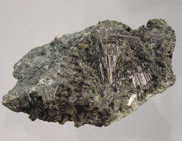


Rock Hill Quarry, Rock Hill, East Rockhill Township, Bucks County, Pennsylvania, USA