| Locality type: | Mining District |
| Classification |
|---|
|
| Species: | Chalcopyrite |
| Formula: | CuFeS2 |
| Confirmation |
|---|
|
| Validity: | Believed Valid |
| Data |
|---|
|
| Mineral Data: | Click here to view Chalcopyrite data |
| Locality Data: | Click here to view Stanley Mining District, Graham County, Arizona, USA |
| Data Identifiers |
|---|
|
| Mindat Occurrence Record ID: | 253834 |
| Long-form Identifier: | 1:3:253834:1 |
| GUID (UUID V4): | b65076a4-e616-4106-b535-7e048dff63a5 |
| Localities for Chalcopyrite in this Region |
|---|
|
| Copper Reef Mine (Copper Reef Consolidated; Rawhide Mountain prospects; Coronado claims; Coronado group; North Star Mine; North Star shaft), Copper Reef Mountain, Stanley Mining District, Graham County, Arizona, USA |
| Cold Spring prospect, Garden Gulch, Stanley Mining District, Graham County, Arizona, USA |
| Geronimo prospect (Geronimo group of claims), Mount Turnbull, Stanley Mining District, Graham County, Arizona, USA |
| Nearest other occurrences of Chalcopyrite |
|---|
|
|
| 4.8km (3.0 miles) | ⓘCobre Grande Mine (Duval Sulfur and Potash Co. Mine; Cowboy Mine; Cowboy tunnel), Cobre Grande Mountain, Aravaipa, Aravaipa Mining District, Graham County, Arizona, USA |
| 7.4km (4.6 miles) | ⓘCold Spring prospect, Garden Gulch, Stanley Mining District, Graham County, Arizona, USA |
| 7.4km (4.6 miles) | ⓘFisher prospect, Mount Turnbull, Aravaipa Mining District, Graham County, Arizona, USA |
| 7.8km (4.9 miles) | ⓘIonia claim, Aravaipa, Aravaipa Mining District, Graham County, Arizona, USA |
| 7.9km (4.9 miles) | ⓘUnnamed copper prospect (13), Horse Mountain area, Aravaipa, Aravaipa Mining District, Graham County, Arizona, USA |
| 7.9km (4.9 miles) | ⓘLandsman claim, Landsman Camp, Aravaipa, Aravaipa Mining District, Graham County, Arizona, USA |
| 8.0km (5.0 miles) | ⓘIron Cap Mine, Landsman Camp, Aravaipa, Aravaipa Mining District, Graham County, Arizona, USA |
| 8.3km (5.2 miles) | ⓘUnnamed Pb-Cu-Mo prospect, Horse Mountain area, Aravaipa, Aravaipa Mining District, Graham County, Arizona, USA |
| 8.7km (5.4 miles) | ⓘHead Center Mine (Harwood Mine; Center Oil and Smelting Co.; Far Mining Enterprises; American Zinc Co.; Aravaipa Mining Co.), Williamson Canyon, Cobre Grande Mountain, Aravaipa, Aravaipa Mining District, Graham County, Arizona, USA |
| 8.8km (5.5 miles) | ⓘSinn Fein Mine (Sin Fin Mine; Tornado Mine; Lundquist Mine), Williamson Canyon, Cobre Grande Mountain, Aravaipa, Aravaipa Mining District, Graham County, Arizona, USA |
| References |
|---|
|
|
| Reference Search (possible matching items) |
|---|
 | | Report (volume) | | Bulletin 763 ARAVAIPA AND STANLEY MINING DISTEICTS GKAHAM COUNTY, ARIZONA BY CLYDE P. ROSS WASHINGTON...enrichment___________ - ________ 72 Aravaipa mining district 76 General features_______________________________...Royal Tinto Mining & Smelting Co __ 92 C. A. Firth group ___ _ _________ 95 Aravaipa Mining Co _____ 95...______ 102 Fisher prospect _ _______ 103 Stanley mining district _ ___ ______ 105 General features _ ___... / } ' / '' / / ) CONTENTS ' V Stanley mining district Continued. Page Mines and prospects _ 106 |  | | Report (volume) | | DEPOSITS OF THE SADDLE MOUNTAIN AND BANNER MINING DISTRICTS, ARIZONA BY CLYDE P. ROSS WASHINGTON GOVERNMENT...prospect__ ___________________________ London-Arizona mine ____________________________ Schneider group...Property map of the Saddle Mountain and Banner mining districts ______ ___ ____________________ XI. A...constituting the principal workings of the London-Arizona mine________________ XV. Geologic section through...XVI. Geologic map of the part of the Banner mining district in the Ray quadrangle __________________________ | 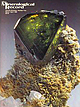 | | Journal (issue) | | Mineralogtcal Record Inc., 7413 N. Mowry Place Tucson, Arizona 85741 Editor & Publisher Wendell E. Wilson Associate...Box 35565 Tucson, Arizona 85740 602-297-6709 Articles The Iron Cap mine, Graham County, A rizona.........Ouray County, Colorado ............... 89 by B. & J. Muntyan Anatase on quartz from Ouray County, Colorado...second class postage (USPS-887-700) Paid at Tucson, Arizona, and additional offices. POSTMASTER: send address...discoveries. Finds made in Arizona (the Iron Cap mine) and in Ouray County, Colorado, are described in |  | | Report (volume) | | vols. 9, 10. Tulsa, Okla. American Institute of Mining and Metallurgical Engineers: Transactions, vols...16, nos. 2-4. Boston, Mass. Arizona Bureau of Mines (University of Arizona Bulletin): Bulletin no. 119...11, 12. San Francisco, Calif. California State Mining Bureau: Bulletin, nos. 79, 94-97. San Francisco...39, 40. Ottawa, Ontario. Canadian Institute of Mining and Metallurgy: Transactions, vols. 27, 28; Bulletin...Bulletin, nos. 153-176. Montreal, Quebec. Canadian Mining Journal, vols. 46, 47. Toronto and Montreal, Canada |  | | Report (volume) | | 4, 5, 8; Museum Paper, nos. 5, 6; County Report, no. 1 (Clay County). Montgomery, Ala. Alberta, Scientific...vols. 3-12. Tulsa, Okla. American Institute of Mining Engineers: Bulletin, nos. 145-156; Technical Publication...1-157; Transactions, vols. 60-76. New York. See also Mining and Metallurgy. American Journal of Science, 4th...Appalachia, vols. 14 (no. 4)-17 (no. 1). Boston, Mass. Arizona State Bureau of Mines: Bulletins 94, 96-99, 104-106...vols. 9-17. San Francisco, Calif. California State Mining Bureau: Bulletins 79, 85-101. San Francisco, Calif |  | | Report (issue) | | Resources of the San Carlos Indian Reservation Arizona By CALVIN S. BROMFIELD and ANDREW F. SHRIDE A...________________ ____ History of mining and production.____ ___________________ . Mining regulations of the San...Carlos Indian Reservation._____ _. Present status of mining and prospecting-_______ _______________ Purpose...King-Wylomene copper area. FIGURE 76. Index map of Arizona showing location of the San Carlos Indian Rese...RESOURCES OF THE SAN CARLOS INDIAN RESERVATION, ARIZONA By CALVIN S BROMFIELD and ANDREW F. ABSTRACT ; |  | | Journal (issue) | | S4.10 Regular Black Finish $3.85 Wood Handled Stanley Prospectors Picks S:i.1O Allow 3 lbs. Shipping...PILLSBURY 22 NEWS A test of your desert knowledge MINING From Here and There on the desert LAPIDARY Current...U. S. Army found a rich gold ledge in southern Arizona nearly 80 years ago —and then lost it again. Many...to abandon the pursuit of the Apaches and start mining this bonanza. The captain was adamant in his refusal...never known. E. Louise Sartor remembers the gold mining camp of Bodie, California, as a quiet, friendly |  | | Report (volume) | | _ Other commodities __________________________ Mining claims _______________________________ Mines, prospects...______________________Greenback mine _________________________ Stanley Lake Creek ______________________ Trail Creek ...5. Diabase dike cutting pink granite ______ 6. Stanley Lake, looking south __________ 6 7 14 16 VIII...prospects, areas of altered or mineralized rocks, and mining areas in the vicinity of the Sawtooth Primitive...part of Idaho and is near or contiguous to six mining districts, none of which was producing ore at the |
|


