| Locality type: | Glacier |
| Classification |
|---|
|
| Species: | Fluorite |
| Formula: | CaF2 |
| Confirmation |
|---|
|
| Validity: | Believed Valid |
| Associated Minerals Based on Photo Data: |
|---|
|
| Quartz | ⓘ1 photo of Fluorite associated with Quartz at this locality. |
| Data |
|---|
|
| Mineral Data: | Click here to view Fluorite data |
| Locality Data: | Click here to view Brenva Glacier, Courmayeur, Aosta Valley, Italy |
| Photo Gallery | View Gallery (8 photos) |
| Data Identifiers |
|---|
|
| Mindat Occurrence Record ID: | 285492 |
| Long-form Identifier: | 1:3:285492:2 |
| GUID (UUID V4): | 7a600bd2-89f6-481a-8ea0-51ad41257927 |
| Nearest other occurrences of Fluorite |
|---|
|
|
| 5.0km (3.1 miles) | ⓘGéant glacier, Chamonix, Chamonix-Mont-Blanc, Bonneville, Haute-Savoie, Auvergne-Rhône-Alpes, France |
| 5.5km (3.4 miles) | ⓘTrou des Romains (Chapy deposit), Sapin Valley, Courmayeur, Aosta Valley, Italy |
| 7.8km (4.8 miles) | ⓘPointe des Periades, Leschaux glacier, Chamonix, Chamonix-Mont-Blanc, Bonneville, Haute-Savoie, Auvergne-Rhône-Alpes, France |
| 8.0km (5.0 miles) | ⓘLeschaux glacier, Chamonix, Chamonix-Mont-Blanc, Bonneville, Haute-Savoie, Auvergne-Rhône-Alpes, France |
| 8.7km (5.4 miles) | ⓘTête Carrèe Mine, Miage Glacier, Courmayeur, Aosta Valley, Italy |
| 11.1km (6.9 miles) | ⓘAiguille de Talèfre southeast slope, Triolet Glacier, Courmayeur, Aosta Valley, Italy |
| 11.4km (7.1 miles) | ⓘTalèfre Glacier, Chamonix, Chamonix-Mont-Blanc, Bonneville, Haute-Savoie, Auvergne-Rhône-Alpes, France |
| 11.9km (7.4 miles) | ⓘTriolet Glacier, Courmayeur, Aosta Valley, Italy |
| 12.8km (8.0 miles) | ⓘChamonix, Chamonix-Mont-Blanc, Bonneville, Haute-Savoie, Auvergne-Rhône-Alpes, France |
| 13.6km (8.4 miles) | ⓘPré de Bar Glacier, Courmayeur, Aosta Valley, Italy |
| References |
|---|
|
|
| Reference Search (possible matching items) |
|---|
 | | Book | | moved some distance down a valley, producing the appearance of a glacier. This is accomplished by the...MeCarshy Creek, Alaskg, The talus forming the rock glacier is derived from the high hours has been re- cliffs...supply of talus is too great for the stream in the valley to remove, the stream is dammed and a lake is...with pick and shovel at a depth of 80 feet. In the Valley of Virginia and in the Blue Grass regions of Kentucky...carried from the Sahara desert to Europe, reaching Italy on the second day of the storm, and Germany and |  | | Book | | igneous. Landslides, wind, running water, and glacier ice all help to move the materials from one place...volcanoes, from modern Turkey through Greece into Italy and the islands of the ninsula, which points like...Oceans as well as in the mid-Pacific. Southern Italy, Iceland, and the African Rift system have eruptions...influence of gravity, less commonly by wind and glacier ice. When dropped by the carriers, they settle...particles. Finally, such agents as running water, glacier ice, wind, and ocean waves all help to Figure |  | | Book (edition) | | greatest its depth the central, between Sardinia and Italy (separated from the eastern by relatively shallow...Sea, 1300 feet in the deepest part of the Jordan valley, and 29,002 feet high in Mount Everest of the...many peaks over 25,000 feet. In America, Death Valley, on the southeast border of California, descends...liilly. can continent, including the Mississippi valley, plain ; also the plains of the lands of Europe...; Hot-water Life. In the north point of Owen's Valley, California, according to Dr. H. C. Wood {Am. Jour |
|
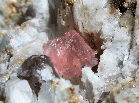

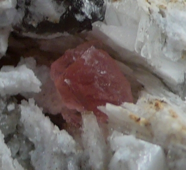


Brenva Glacier, Courmayeur, Aosta Valley, Italy