| Locality type: | Quarry |
| Classification |
|---|
|
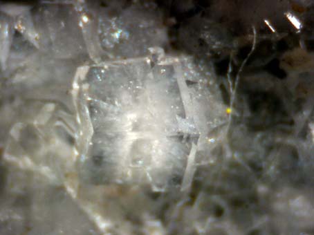
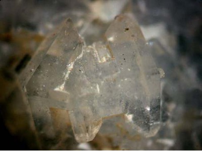
| Species: | 'Phillipsite Subgroup' (not an IMA approved species) |
| Habit: | usually as twins showing pseudo-orthorhombic, pseudotetragonal, and even pseudocubic symmetry. |
| Colour: | colourless when fresh |
| Confirmation |
|---|
|
| Validity: | Believed Valid |
| Associated Minerals Based on Photo Data: |
|---|
|
| Gismondine-Ca | ⓘ28 photos of Phillipsite Subgroup associated with Gismondine-Ca at this locality. |
| Thomsonite-Ca | ⓘ26 photos of Phillipsite Subgroup associated with Thomsonite-Ca at this locality. |
| Calcite | ⓘ10 photos of Phillipsite Subgroup associated with Calcite at this locality. |
| Montmorillonite | ⓘ4 photos of Phillipsite Subgroup associated with Montmorillonite at this locality. |
| Tobermorite | ⓘ4 photos of Phillipsite Subgroup associated with Tobermorite at this locality. |
| Mesolite | ⓘ4 photos of Phillipsite Subgroup associated with Mesolite at this locality. |
| Gyrolite | ⓘ3 photos of Phillipsite Subgroup associated with Gyrolite at this locality. |
| Pyrite | ⓘ2 photos of Phillipsite Subgroup associated with Pyrite at this locality. |
| Apophyllite Group | ⓘ2 photos of Phillipsite Subgroup associated with Apophyllite Group at this locality. |
| Goethite | 1 photo of Phillipsite Subgroup associated with Goethite at this locality. |
| Data |
|---|
|
| Mineral Data: | Click here to view Phillipsite Subgroup data |
| Locality Data: | Click here to view Arensberg, Zilsdorf, Walsdorf, Gerolstein, Vulkaneifel, Rhineland-Palatinate, Germany |
| Photo Gallery | View Gallery (9 photos) |
| Data Identifiers |
|---|
|
| Mindat Occurrence Record ID: | 29298 |
| Long-form Identifier: | 1:3:29298:4 |
| GUID (UUID V4): | 12a2aaf3-ba3b-43de-b91d-084e56f65d98 |
| Nearest other occurrences of Phillipsite Subgroup |
|---|
|
|
| 4.3km (2.7 miles) | ⓘGraulay quarry, Hillesheim, Gerolstein, Vulkaneifel, Rhineland-Palatinate, Germany |
| 4.5km (2.8 miles) | ⓘAuf Dickel (incl. Nonnental), Rockeskyll volcanic complex, Rockeskyll, Gerolstein, Vulkaneifel, Rhineland-Palatinate, Germany |
| 4.8km (3.0 miles) | ⓘFeuerberg, Hohenfels-Essingen, Gerolstein, Vulkaneifel, Rhineland-Palatinate, Germany |
| 6.6km (4.1 miles) | ⓘRadersberg quarry, Dreis-Brück, Daun, Vulkaneifel, Rhineland-Palatinate, Germany |
| 9.2km (5.7 miles) | ⓘRother Kopf, Roth, Gerolstein, Gerolstein, Vulkaneifel, Rhineland-Palatinate, Germany |
| 10.4km (6.4 miles) | ⓘDüngerlei, Hoffeld, Adenau, Ahrweiler, Rhineland-Palatinate, Germany |
| 10.6km (6.6 miles) | ⓘBurgkopf, Hoffeld, Adenau, Ahrweiler, Rhineland-Palatinate, Germany |
| 13.9km (8.6 miles) | ⓘKalem, Birresborn, Gerolstein, Vulkaneifel, Rhineland-Palatinate, Germany |
| 15.5km (9.6 miles) | ⓘGewaderköpfchen, Reimerath, Kelberg, Vulkaneifel, Rhineland-Palatinate, Germany |
| 16.3km (10.2 miles) | ⓘSchönfelder Maar, Schönfeld, Stadtkyll, Gerolstein, Vulkaneifel, Rhineland-Palatinate, Germany |
| References |
|---|
|
|


Arensberg, Zilsdorf, Walsdorf, Gerolstein, Vulkaneifel, Rhineland-Palatinate, Germany