| Classification |
|---|
|
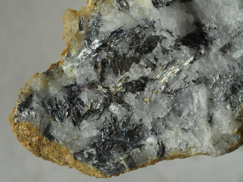
| Species: | Boulangerite |
| Formula: | Pb5Sb4S11 |
| Confirmation |
|---|
|
| Validity: | Believed Valid |
| Associated Minerals Based on Photo Data: |
|---|
|
| Pyrite | ⓘ2 photos of Boulangerite associated with Pyrite at this locality. |
| Jamesonite | ⓘ1 photo of Boulangerite associated with Jamesonite at this locality. |
| Ankerite | ⓘ1 photo of Boulangerite associated with Ankerite at this locality. |
| Quartz | ⓘ1 photo of Boulangerite associated with Quartz at this locality. |
| Data |
|---|
|
| Mineral Data: | Click here to view Boulangerite data |
| Locality Data: | Click here to view Straßegg (Straßeck), Gasen, Weiz District, Styria, Austria |
| Photo Gallery | View Gallery (9 photos) |
| Data Identifiers |
|---|
|
| Mindat Occurrence Record ID: | 301866 |
| Long-form Identifier: | 1:3:301866:8 |
| GUID (UUID V4): | 38fae484-9223-495f-b613-a7b71f4980b3 |
| Nearest other occurrences of Boulangerite |
|---|
|
|
| 2.1km (1.3 miles) | ⓘSchweinskogel, Stanz im Mürztal, Bruck-Mürzzuschlag District, Styria, Austria |
| 13.3km (8.2 miles) | ⓘLead mine, Graschnitzgraben, Sankt Marein im Mürztal, Bruck-Mürzzuschlag District, Styria, Austria |
| 24.8km (15.4 miles) | ⓘKaltenegg, Southern District, Prinzkogel mines, Prinzkogel (Prinzenkogel), Rettenegg, Weiz District, Styria, Austria |
| 30.8km (19.1 miles) | ⓘArzberg am Semmering mines, Hasen valley, Fröschnitz valley (Fröschnitz), Steinhaus am Semmering, Spital am Semmering, Bruck-Mürzzuschlag District, Styria, Austria |
| 35.8km (22.3 miles) | ⓘHaidbachgraben (Myrthengraben; Myrtengraben; Heidbachgraben), Semmering, Neunkirchen District, Lower Austria, Austria |
| 40.5km (25.2 miles) | ⓘMagnesite deposit, Eichberg, Gloggnitz, Neunkirchen District, Lower Austria, Austria |
| 64.4km (40.0 miles) | ⓘWald tunnel, A9 Motorway tunnels, Wald am Schoberpass, Leoben District, Styria, Austria |
| 79.3km (49.3 miles) | ⓘBischofeck North, Bischofeck, Kliening, Bad Sankt Leonhard im Lavanttal, Wolfsberg District, Carinthia, Austria |
| 80.6km (50.1 miles) | ⓘOberzeiring, Pölstal, Murtal District, Styria, Austria |
| 80.9km (50.3 miles) | ⓘMagnesite deposit, Sunk, Hohentauern, Murtal District, Styria, Austria |
| References |
|---|
|
Bojar, H.-P. (1999): 1189. Benleonardit, Diaphorit, Hessit, Gersdorffit, Greenockit, Magnetit, Meneghinit, Ullmannit, 2 unbekannte Cd-hältige Sulfide und ein nicht näher bestimmtes Ag-hältiges Pb-Sb-Sulfosalz vom Straßegg, Breitenau am Hochlantsch, Steiermark. Pp. 228-229 in Niedermayr, G. et al. (1999): Neue Mineralfunde aus Österreich XLVIII. Carinthia II, 189./109., 201-236. |


Straßegg, Gasen, Weiz District, Styria, Austria