 | | Journal (article/letter/editorial) | | Oklahoma, Kansas, and Missouri and the world-class Viburnum Trend of southeastern Missouri. Deposits in both...districts. THE TRI-STATE DISTRICT History of the Missouri Portion of the Tri-State District The Tri-State...Tri-State district, extending from southwestern Missouri through Kansas into Oklahoma (fig. l), was one of the...small-scale mining in 1849 on Turkey Creek in Joplin, Missouri (Dressel 1989). The history of the district...titled “Minerals of the Vanadinite Mine, Mohave County, Arizona.” 400 ROCKS 81 MINERALS rized in Lasnianis |  | | Journal (article/letter/editorial) | | page): Galena, St. Joseph Lead mine, Viburnum, Missouri, Viburnum Trend district; 6 cm on edge; James...the mines of the Viburnum Trend in southeastern Missouri accounted for 90 percent of the United States'...Beales (1967). The source of lead in southeastern Missouri is described by Doe and Delevaux (1972). M V T...arsenic, and silver minerals. marcasite, pyrite, chalcopyrite, fluorite, barite, calcite, and quartz from...of the Crescent Formation, Robertson Pit, Mason County, Washington" (January/February 1988). From 1961 | 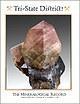 | | Journal (issue) | | NUMBER 2 • $25 The Tri-State Mining District Missouri-Kansas-Oklahoma by Denise Bicknell Wendell E...on GALENA and dolomite, 19 cm, from Webb City, Missouri. Mark Pospisil collection, Joe Budd photo. Associate...Tucson USA Visit us at these international shows: Houston Ste. Marie Denver Munich USA France USA Germany...and Riverpark Inn Rhodochrosite, Sweet Home Mine, USA, 10 cm Photo: Malte Sickinger MARCUS BUDIL Monaco...Shenandoah, TX 77385 The Tri-State Mining District Missouri-Kansas-Oklahoma Denise Bicknell 16711 East Whimbrel |  | | Report (issue) | | ... Tri-State district, Oklahoma, Kansas, and Missouri ........................................................................... ................. Missouri .............................................................................. Southeastern Missouri district ........................... 56 57 58 61...showing jasperoid-bearing areas in 36. Southwest Missouri, Oklahoma, Kansas, and Arkansas ................Illinois, Iowa, Kentucky, Wisconsin, and southeastern Missouri ............................ 44. Nevada ..... |  | | Journal (issue) | | No. 8 • August 2017 16 THE NEW CARVER AGATE FIELD Does the material match the hype? 10 By John Carver...beryl, and more. By Jim Landon Regular Columns Field Notes .......................... 6 Lapidary of the...Heritage Auctions/ HA.com photo Rock & Gem 43 Field notes READER LETTERS Birthday Cake I thought your...expansion, especially Eleanor Krimmel, from the USA, whose generous donations really put us over the...rockngem.com Rock & Gem 9 The Carver Agate Field Does the Material Match the Hype? This nodule |  | | Catalog/List | | New York. He would pack up the family for these field collecting adventures – they would spend hours bashing...SCEPTER QUARTZ Denny Mountain, King Co., Washington, USA A raspberry Quartz Scepter from Denny Mountain with...Quarry, St Johnsville, Montgomery Co., New York, USA A lustrous Quartz scepter with two doubly- terminated...HERKIMER QUARTZ ‘DIAMOND’ Herkimer Co., New York, USA Unusual flat, tabular variety of ‘Herkimer Diamond’...WATER-CLEAR QUARTZ ‘DIAMOND’ Herkimer Co., New York, USA Large, single, water clear ‘Herkimer Diamond’ with |  | | Journal (volume) | | Mo. Editorial Staff, J ournal. Coal Mining in Missouri. H. Engineering and Mining Barytes. Blake...Platteville, Wis. Petroleum in the Appalachian Field. Petroleum in Indiana and Ohio. Gibson, Thomas ...Mining Engineer, St. Louis, Mo. Lead in Southeast Missouri. Young, C. M. Mining Engineer, Lawrence, Kan... Zook, Jesse A. Statistician, Joplin, Mo. Zinc Mining in Missouri and Kansas. THE STATE GEOLOGICAL...GEOLOGISTS. State. Alabama. Connecticut. Iowa. Missouri. Nebraska. State. Name and Address. Name and |  | | Journal (volume) | | Colorado, electric mine-signal system.. 49 Olancho county, Honduras. Akin, A. D 167, 1018 Alabama, mineral...Company 624, 865, report American canyon, Humboldt county, Nevada, placer camp Enterprises In South America...Of black powder and dynamite *f Anantapur Gold Field, Ltd.. India "JJ 311 ... v. • An-Chi ironfield..."^^ MINING AND SCIENTIFIC PRESS Vol. 107 V. County of Greenlee Arkansas, Blue, and Magazine mountains...'.'.'.'.'. J' S?"^?- Western B ack Warrior Gila county, Arizona §!'^"^1' ptnT ."!• r^p"on' Sl«-<=''^^te'' |  | | Journal (volume) | | United States—Production of Barytes in the World—Missouri—North Carolina—Tennessee — Virginia—Market Co...Hein¬ rich Ries, p. 129)—Clay Deposits—Colorado—Missouri—North Caro¬ lina—Washington—Austria—Canada — France...Lead Mining in 1902—Colorado—Idaho—Iowa—Kansas—Missouri—Mon¬ tana—Nevada—Tennessee—Texas—Utah—World’s...Points— Lead-Tellurium Alloys—Lead Ores of Southeast Missouri—Importation of Lead Ores—Sampling Ores—Johnston...Antimony in Hard Lead—Lead Smelting in Southeast Missouri—Lead at Freiberg—Laurin—Murcia—Smelting of Lead |  | | Book | | and of agricultural geology. To cover so varied a field in a short book renders necessary omission of reference...Classification — — — — — Silver— Cob.ilt Field. CHAPTER Ores of k- 1 VIII Metals— Nickel,...Indications of Oil. Essentials of Oil-fields and Oil-field Structures. Estimation of Mexico Oil Resources....Baicoi oilfield 56. Section across the German potash field north of the tains $7. The water table in an island...colors. They are too small to be weighed in the field, but on an average 35 " colors " weigh one grain |  | | Journal (issue) | | NOW-HOW fifty years Boyles Bros. has led the field of diamond drilling for exploration, long-hole...maintenance costs on your gyrator crushing equipment. Our Field Man will be glad to make an analysis of your problems...sometimes cut hourly output to 3 loads. Under 7s County Excavators, normal conditions, however, the high-speed...daily. Offers important savings for YOU Like Lake County Excavators, it will pay you to investigate the...road. Joseph Peppe, President of Lake commend County Corryell—Trademark ee HIGH SPEED on / RUBBER |  | | Journal (volume) | | Conn . Indianapolis, Ind . Jacksonville , Fla. Joplin , Mo. Kansas City , Mo. Knoxville , Tenn . Los..., at the front door of the Court House of Iron County, in the City of Parowan , Utah , on the 26th day...situated in the State Line Min- ing District , Iron County, State of Utah , located , recorded and known under...State Line Mining Dis Sand Aqua , trict , Iron County, Utah , viz : Gravel Bar and Big Locust ; and also...Jennie No. 6 Lode Mining Claim ; townsite, Iron County, Utah: The Jennie No. 7 Lode Mining Claim ; The |  | | Journal (volume) | | Oredressing, Handbook of, A. W. Allen Prospectors' Field Book, von Bernewitz Useful Minerals,— McLeod Miners'...Policy Anglo-Dominion Company to develop Athabaska Field British control of Oil Resources H. British and...Manitoba 256, 463 Dominion Royalties on, 898 Dover Oil Field, Ontario 872 v Economics and Politics 474 Imperial...RIVER BASIN. T.he Geological Survey has sent four field parties to investigate further the oil and other...number of prospectors going to the Fort Norman field was not as great as had been expected, but there |
|


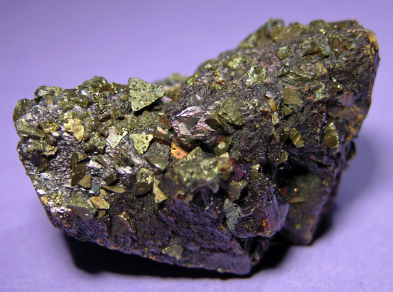

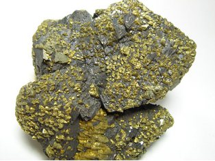


Joplin Field, Jasper County, Missouri, USA