 | | Report (volume) |
| A. F. Rogers, Stanford University, Palo Alto. Colorado.........Prof. R. D. George, Boulder. Connecticut...See Bauxite and Hallpysite. Asbestos. Tallapoosa County, with corundum deposits near Dudleyville; not found...commercial quantity or quality. Asphalt. Colbert County, small quantity has been shipped from near Leighton;...following localities: Bibb County, Pratts Ferry; Calhoun County, near Tampa; Clay County, T. 20, Pv. 7 E.; Jefferson...Jefferson County, at Elyton; Lee County, at Chewacla lime works; St. Clair County, at Gfeensport; Shelby |
 | | Report (issue) |
| . . . . . . . . . . . . . . . . . . . . . . 1 County Listings. . . . . . . . . . . . . . . . . . . .... . . . . . . . 4 Mineral Localities Listed by County . . . . . . . . . . . . . . . . . . . . . . . .... . . . . . . . . . . . . . . . . . . 7 Beaver County . . . . . . . . . . . . . . . . . . . . . . . ... . . . . . . . . . . . . . . . . . 7 Box Elder County . . . . . . . . . . . . . . . . . . . . . . . .... . . . . . . . . . . . . . . . . . . 10 Cache County . . . . . . . . . . . . . . . . . . . . . . . |
 | | Report (volume) |
| ............................................. Colorado.................................................................................. 102 District of Columbia ..........................................especially from those of Arkansas, California, Colorado, New Mexico, Oregon, South Dakota, Tennessee,...minerals and rocks, their occurrence and uses: Colorado State Geol. Survey Bull. 6, 1913. 8 USEFUL...See Bauxite and Halloysite. Asbestos. Tallapoosa County, with corundum deposits near Dudleyville; not found |
 | | Book (volume) |
| ...........................................59 Colorado ...............................................................548 Table of Maps Page Alabama County Map ...................................................................................4 Alaska County and Stream Map ......................................................................22 Arizona County Map ................................................................................49 Arkansas County Map .......................................... |
 | | Book (volume) |
| ...........................................47 Colorado ................................................rights, so remember you were told. If in doubt, a county map will tell you who the legal owner is. Good...gemmy qualities for cutting and polishing. AUTAUGA COUNTY PRATTVILLE, N. 6 mi., and just E of the Birmingham...were well known to prehistoric Indians.) BARBOUR COUNTY BAKER HILL, SE 1 mi. : 1 in a deep ravine, as a...deep red to variegated⎯ocher. BIBB COUNTY GENERAL AREA: c county gravel pits along the Cahaba R.⎯gemmy |
 | | Report (issue) |
| financially in part by, the numerous Federal, State, County and City agencies listed on pages A133 to A136..._____ District and regional studies._________________ Iron deposits in the Birmingham district, Alab...North Carolina.._ __________________________ Magnetite deposits in New York_______ Studies in Utah__...metals and industrial minerals ______________ District studies.____________________________ Beryllium...Beryllium deposits in the Tarryall area, Colorado ____________________________ Beryllium deposits at Spor Mountain |
 | | Report (issue) |
| ______________________ Studies in Colorado. ____________________ East Tintic silver-lead district, Utah_ _____ Central...Central mining district, New Mexico._-___ Lead, zinc, and related ores of the Central and Eastern States___--_-__--_--_----_...Light metals and industrial minerals-_____________ District and regional studies-________________ Beryllium...area, White Pine County, Nevada-__________ Beryllium in the Lake George district, Colorado-.-. _ ________________________...________________________ Pegmatites of the Spruce Pine district, North Carolina.______________________ Vermiculite |
 | | Report (issue) |
| History of the Iron Industry in Utah · .1 Beaver County . . . . . . . . . . . . .2 Beaver Lake Mountains.... . . · . 11 Montreal magnetite-copper property . . . . . .11 Bawana magnetite-copper mine . . . . .... . . . .11 Maria magnetite-copper ore body . . . . . . . .11 Wah Wah Mountains deposits . . . . . . ...13 Wah Wah pass prospects · . . . . 13 Box Elder County . . . . . . . . . . . . . . · .... Pilot Range...Mining Company .. . · 14 14 14 16 17 17 Cache County . . . . . . . . . . . . . Bear River Range deposits |
 | | Report (issue) |
| Individual workings are not included if deposit or district data are presented. A deposit was subjectively...column heading "County/Quad" contains second or third order political units -county, province, or quadrangle...each deposit include: location information, district, owner or operating company, grades and volumes...Arizona United States Cali forni a United States Colorado United States Idaho United States Montana United...IJiCd L'irt' J'M AUNS 1 1 RE USHT AUNS USCO USCA USA* USID AUNS USHT USAZ USID 1VCO USAZ AUNS USHT USHT |
 | | Journal (article/letter/editorial) |
| General 1st —Mineral Society of the District of Columbia District of Columbia 2nd—Mississippi Gem & Mineral...Sojka was in charge of arrangements. The Fulton County Mineral Club of New York went to Westmoreland New...distributed triphylite from Palermo, N . H. and magnetite from Windham, Vt. Andrew Palmer reported on the...local material to be traded at the Jamboree in Colorado Springs in July. The boys also prepared a geology...Rice's Pit in the city of Hampton. The Rockland County Mineral and Gem Society of New York will have held |
 | | Report (issue) |
| --------------Cleburne County ----------~----------------- Tallapoosa County --------------------------Alaska...------------------Cochise County -----------------------------Gila County --------------------------------Greenlee...ee County ----------------------------R[aricopa County ----------------------------R[ohave County --...-----------------------------Pima County -------------------------------Pinal County -------------------------------Santa...-------Santa Cruz County --------------------------'ravapai County -----------------------------'ruma |
 | | Book |
| of each Utah county. History, mineral deposits, and mining activity of each Utah county are covered....1849-50 near the little town of \Vales in Sanpete County, but the transportation problem prevented utilization...Quarters mine, first to open in what is now Carbon County, began opera• tions in 1878. In 1858, Isaac Grundy...American Fork Canyon, the Park City district, and the Tintic district with their near-surface silver deposits...Park City district; the Tintic Standard and Chief Consolidated mines of the Tintic district; the Horn |
 | | Report (issue) |
| ................................... Tri-State district, Oklahoma, Kansas, and Missouri ................Clifton-Morenci district, Arizona .............................. Bisbee (Warren) district, Arizona .......Ely (Robinson) district, Nevada .............................. Leadville district, Colorado ..............Gilman (Red Cliff) district, Colorado ...................... Aspen district, Colorado ................................................. Eureka district, Nevada ............................................. |
 | | Report (issue) |
| 501. During fiscal 1963, numerous Federal, State, County, or Municipal agencies listed on page A247 have..._____ Utah.. _--_______-__-_______--_______._ Colorado ______________________________ Kansas -_--___...Southern Rocky Mountains and plains ___________ Colorado Plateau_-_____--__-____-____--_-_-_-_ Basin and...and Range region. _______________________ Columbia Plateau and Snake River Plain. ________ Pacific coast..._. Federal agencies.___________________ State, county, and municipal agencies. 247 247 247 U.S. Geological |
 | | Report (issue) |
| districts, under the general bibliography for the county or state and under the discussion of a particular...(8) Geology and Ore Deposits of the Park City district, Utah: U. S. Geol. Survey, Prof. Paper, 77. Boutwell...Geology and Ore Deposits of the Bingham mining district, Utah: U. S. Geol. Survey, Prof. Paper, 38. Burling...165-226. Clark, F. R. (15) Coal near Thmopson, Grand County, Utah: U. S. Geol Survey, Bull. 541, pp. 453-477...Stratigraphic results of a reconnaissance in western Colorado and eastern Utah: Jour. Geol., Vol. 15, No.7, |
 | | Report (issue) |
| ................................... Hillsboro district.................................................Camp................................. Kingston district.................................................20 Page Mining districts Continued Kingston district Continued Veins and bedding-replacement deposits.................................. Tierra Blanca district............................................. Mining............................. Carpenter (Swartz) district........................................ Introduction |
 | | Report (issue) |
| listed on pages A253A258. Numerous Federal, State, county, and municipal agencies listed on pages A205-A210...---34 Utah --------------------------------35 Colorado ----------------------------35 lCansas ------..._ Quaternary geology ______________________ _ Colorado Plateau -----------------------------Geologic...95 Geophysical studies ------------------------Columbia Plateau and Snake River Plain _______ _ 95 95...agencies ------------------------------ 205 State, county, and municipal agencies __________ _ 205 U.S. Geological |
 | | Report (issue) |
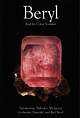
| Federico Pezzatta Page 26 Mount Antero: The Peak of Colorado Beryl Collecting Mark I. Jacobson Page 14 Crystal...from the University of New Orleans in Louisiana (USA), with the lowdown on beryl mineralogy An ancient...recorded from the Alger quarry in New Hampshire (USA). The crystal weighed 455 kilograms. 2m: The Queen...near Sabsar, on the Gilgit to Skardu Road, Skardu district, Northern Areas, Pakistan. Collection Ty Lawrence;...and quartz; 15 cm from the Shigar Valley, Skardu district, Northern Areas, Pakistan Because it is associated |
 | | Report (issue) |
| Professional Paper 525. Numerous Federal, State, county, and municipal agencies listed on pages A221-A225...37 Utah _________________________________ _ 38 Colorado _____________________________ _ 38 ]{ansas __...41 Texas ________________________________ _ 42 Colorado River basin ___________________ _ 42 Pacific coast...___________ _ Geology of Precambrian rocks of Colorado ____ _ Stratigraphic and paleontologic studies...Geophysical investigations __________________ _ Colorado Plateau ______________________________ _ Geophysical |
 | | Report (issue) |
| longer district Hulin, respectively. the principal features of each gold-bearing district are described...gold-mining operations; the and Geology and the County a number of bulletins on certain phases and...reports and records, and private reports. Some county records were examined. The author was assisted...Tuolumne- Coloma El Dorado Tuolumne Tuolumne Columbia Confidence Placer — 36 36 37 37 37 37 38 38...Emigrant 42 42 42 43 43 43 „ Placer _EI English District 41 Kern Damascus... Deer Creek Deer Valley |
 | | Report (issue) |
| .. : ......... · Correlation with Wyoming and Colorado .. .............................................INTRODUCTION. reports are those on the Mercur district, by J. E. Spurr and S. F. Emmons; the Bingham...Bingham The senior author, J3. S. Butler, began district, by J. M. Boutwell, Arthur Keith, and field work on...deposits of Utah in the S. F. Emmons; the Park City district, by J. M. FIELD .WORK AND AUTHORSHIP. summer...author, G. F. Loughlin, began work in the Tintic district in 1911 in collaboration with Waldemar Lindgren |
 | | Book |
| Gold and silver ores from the province of British Columbia. de aser eCOOtanie CString s vis. huts wteriey...CONTENTS—Continued. ORES—Continued. . Tron ores—Continued. Magnetite or magnetic iron ore..........+-+.4+Specimens...distribution of magne- Mineral associations of magnetite. ............ Bicenimiorspaviic:ITOMs semper asp...ieee Silver ores from the provinces of British Columbia and Quebec. ...Graphite.—Lot 3, range II. of Grenville, Argenteuil county, Q.—Coll., R. Bell, 1856. (1228.) — columnar.——Lot |
 | | Journal (issue) |
| Field guide to gems and minerals of the Mohave and Colorado deserts and adjacent areas. Paperback, $2.00 GOLD... WARRIORS OF THE COLORADO by Jack Forbes. Covers all Indian tribes of the Colorado River and is especially...illustrated. Hardcover. $5.00. JEEP TRAILS TO COLORADO GHOST TOWNS by Robert L. Brown. An illustrated...informal history of life in the mining camps deep in Colorado Rockies. Fifty-eight towns are included the almost...Nevada. Series II includes New Mexico, Utah and Colorado. Reproduced on fine paper. They show old towns |
 | | Book |
| are reported by county of occurrence. Map 1-2 shows the county boundaries and county names. When possible...II TRANSVERSE RANGES X PENINSULAR RANGES XI ~ COLORADO DESERT GOLD-BEARING AREA Map 1-1. Map of California...,o Map 1-2. Outline map of California showing county boundaries. __ _) 4 MINERALS OF CALIFORNIA...in placers of the Potholes District of Imperial County, near the Colorado River about 10 miles north...reported from San Ysidro, San Diego County, in 1828 ; from Los Angeles County, San Francisquito Canyon, in 183 |


