| Locality type: | Tunnel |
| Classification |
|---|
|
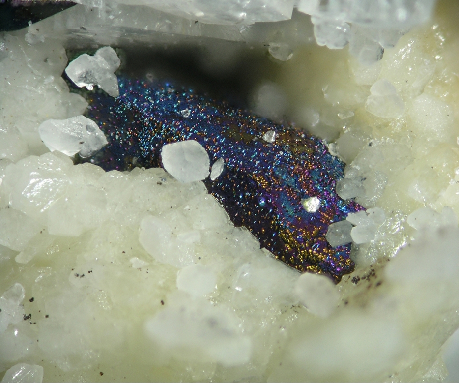
| Species: | 'Tetrahedrite Subgroup' (not an IMA approved species) |
| Formula: | Cu6(Cu4C22+)Sb4S12S |
| Quality for species: | Good crystals or rich for species - important (!) |
| Abundance at site: | Common |
| Confirmation |
|---|
|
| Validity: | Confirmed |
| Confirmation Methods: | Visually Identified |
| Data |
|---|
|
| Mineral Data: | Click here to view Tetrahedrite Subgroup data |
| Locality Data: | Click here to view Schirmeck tunnel, Schirmeck, Molsheim, Bas-Rhin, Grand Est, France |
| Photo Gallery | View Gallery (2 photos) |
| Data Identifiers |
|---|
|
| Mindat Occurrence Record ID: | 417501 |
| Long-form Identifier: | 1:3:417501:8 |
| GUID (UUID V4): | ecc8b31a-6e98-4bc0-942b-a8175257fdac |
| Nearest other occurrences of Tetrahedrite Subgroup |
|---|
|
|
| 15.1km (9.4 miles) | ⓘCharbes Sb Veins, Lalaye, Sélestat-Erstein, Bas-Rhin, Grand Est, France |
| 18.3km (11.3 miles) | ⓘLubine mines, Lubine, Saint-Dié-des-Vosges, Vosges, Grand Est, France |
| 28.2km (17.5 miles) | ⓘHaus Rappoltstein vein, Neuenberg, Sainte-Marie-aux-Mines, Colmar-Ribeauvillé, Haut-Rhin, Grand Est, France |
| 28.2km (17.6 miles) | ⓘGiftgrube mine, Sankt Jakob vein, Neuenberg, Sainte-Marie-aux-Mines, Colmar-Ribeauvillé, Haut-Rhin, Grand Est, France |
| 28.3km (17.6 miles) | ⓘTiefstollen, Chrétien Vein, Neuenberg, Sainte-Marie-aux-Mines, Colmar-Ribeauvillé, Haut-Rhin, Grand Est, France |
| 28.5km (17.7 miles) | ⓘSankt Peter mine (high level), Sankt Wilhelm vein, Neuenberg, Sainte-Marie-aux-Mines, Colmar-Ribeauvillé, Haut-Rhin, Grand Est, France |
| 28.5km (17.7 miles) | ⓘHaus Rappolstein, Haus Rappoltstein vein, Neuenberg, Sainte-Marie-aux-Mines, Colmar-Ribeauvillé, Haut-Rhin, Grand Est, France |
| 29.4km (18.2 miles) | ⓘGabe Gottes Mine, Sankt Jakob vein, Neuenberg, Sainte-Marie-aux-Mines, Colmar-Ribeauvillé, Haut-Rhin, Grand Est, France |
| 29.7km (18.4 miles) | ⓘl'Aphanèse mine, Sankt Johann vein, Neuenberg, Sainte-Marie-aux-Mines, Colmar-Ribeauvillé, Haut-Rhin, Grand Est, France |
| 29.9km (18.6 miles) | ⓘRemémont, Entre-deux-Eaux, Saint-Dié-des-Vosges, Vosges, Grand Est, France |
| References |
|---|
|
|


Schirmeck tunnel, Schirmeck, Molsheim, Bas-Rhin, Grand Est, France