| Locality type: | Mining District |
| Classification |
|---|
|
| Species: | Chalcocite |
| Formula: | Cu2S |
| Confirmation |
|---|
|
| Validity: | Believed Valid |
| Associated Minerals Based on Photo Data: |
|---|
|
| Chalcopyrite | 1 photo of Chalcocite associated with Chalcopyrite at this locality. |
| Data |
|---|
|
| Mineral Data: | Click here to view Chalcocite data |
| Locality Data: | Click here to view Ouray Mining District, Ouray County, Colorado, USA |
| Data Identifiers |
|---|
|
| Mindat Occurrence Record ID: | 434096 |
| Long-form Identifier: | 1:3:434096:6 |
| GUID (UUID V4): | e2e2a766-efe6-4717-a280-53a1a4f8e143 |
| Localities for Chalcocite in this Region |
|---|
|
| Campbell Mine, Ouray Mining District, Ouray County, Colorado, USA |
| Mineral Farm Mine, Canyon Creek, Ouray Mining District, Ouray County, Colorado, USA |
| Nearest other occurrences of Chalcocite |
|---|
|
|
| 3.4km (2.1 miles) | ⓘMineral Farm Mine, Canyon Creek, Ouray Mining District, Ouray County, Colorado, USA |
| 3.8km (2.4 miles) | ⓘNews Boy Mine, Paquin Mining District, Ouray County, Colorado, USA |
| 4.6km (2.9 miles) | ⓘSenorita Mine, Paquin Mining District, Ouray County, Colorado, USA |
| 10.6km (6.6 miles) | ⓘFrank Hough Mine (Hough Mine; Patented Claim: Frank Hough; MS 549), Galena Mining District (Henson Creek Mining District), Hinsdale County, Colorado, USA |
| 13.0km (8.1 miles) | ⓘDolly Varden Mine (Varden Belle Mine; Patented Claim: Dolly Varden; MS 172), Galena Mining District (Henson Creek Mining District), Hinsdale County, Colorado, USA |
| 13.4km (8.4 miles) | ⓘSmuggler Vein, Smuggler Union Mine, Marshall Basin, Telluride Mining District, Colorado, USA |
| 14.2km (8.8 miles) | ⓘGuston Mine, Ouray County, Colorado, USA |
| 14.4km (8.9 miles) | ⓘYankee Girl Mine, Ouray County, Colorado, USA |
| 16.7km (10.4 miles) | ⓘMoro Mine (Moro Extension; Moro Tunnel Site; Ajax Limited; MS 13811; Moro-Ajax Mine; Moro Mill Site; Patented Claims: Moro Limited; MS 13811; Unpatented Claims: Ajax No. 2), Galena Mining District (Henson Creek Mining District), Hinsdale County, Colorado, USA |
| 21.2km (13.2 miles) | ⓘPride of America Mine, Galena Mining District (Henson Creek Mining District), Hinsdale County, Colorado, USA |
| References |
|---|
|
|
| Reference Search (possible matching items) |
|---|
 | | Journal (article/letter/editorial) | | T R I C T, located about 4 miles north of Ouray, Colorado, comprised an area of approximately 3.6 square...Carbonate Hill was used in early reports on the district and is believed to be derived from the thin limestone...mines flourished until the silver panic of 1893. Mining rallied about 1912 for a few short years and then...Figure 2 (right). Topographic map of the Paquin mining district showing the principal mines along the south...showing the location of the Paquin mining district in Ouray County, Colorado. Cartography courtesy William |  | | Report (issue) | | Deposits of the Uncompahgre (Ouray) Mining District, Southwestern Colorado Professional Paper 1753 U.S...western San Juan Mountains region of southwestern Colorado. In the foreground is a broad, gently south-sloping...flat-bottomed, glacier-carved valley. The town of Ouray (about 7,800 feet altitude), just visible through...Dollar Highway” south of Ouray, parallels the Uncompahgre River valley to connect Ouray with Montrose to the...and other canyons and mountain passes to connect Ouray with Silverton and Durango to the south. The many |  | | Book | | MINES AND MINERALS OF THE GREAT AMERICAN RIFT (COLORADO-NEW MEXICO) Sine —_—< ¢ te om At _SHT 40...MINES AND MINERALS OF THE GREAT AMERICAN RIFT (COLORADO-NEW MEXICO) Richard Walker Holmes and Marrianna...Mines and minerals of the Great American Rift (Colorado-New Mexico). Bibliography: p. Includes index...index. 1. Mines and mineral resources—Colorado. 2. Mines and mineral resources—New Mexico. I. Kennedy, Marrianna...minerals of the Great American Rift in New Mexico and Colorado. Great American Rift is the name we use for a | 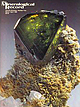 | | Journal (issue) | | 602-297-6709 Articles The Iron Cap mine, Graham County, A rizona.................................81 by...discoveries in Ouray County, Colorado ............... 89 by B. & J. Muntyan Anatase on quartz from Ouray County...County, Colorado ........................ 103 by T. Rosemeyer, E. Raines & R. Stoufer Departments Notes...made in Arizona (the Iron Cap mine) and in Ouray County, Colorado, are described in three articles, and a...huge i show organized by Herb Duke at the Pima County Fairgrounds. Following the advertising section |  | | Report (issue) | | _________________ ___. Nevada ___________ Elko County. - ______ ... _ Star mine, Harrison Pass _____... Tuscarora Range _____ _ ._. ________ Humboldt County Golconda manganese-tungsten depositNorth workings...Lincoln County__-__-----_-----_-----___ Tern Piute district....... __ ___ ... Mineral County____-_______________...naine________________ Mine near Green Talc mine. _____ Nye County ____ _._-___-________-___ Gabbs area __ _____________________..._____ Brucite and magnesite deposits. __ Pershing County __ Rocks in the West Humboldt Range ..~ Limerick |
|


