 | | Report (issue) | | copper, lead, and zinc in acid-rock drainages of Colorado using natural clinoptilolite Preliminary Held...endorsement by the U.S. Government. 1Denver, Colorado CONTENTS Page Abstract ......................clinoptilolite-rich rock in selected acid-rock drainages in Colorado ................................................of zinc, copper, and lead in water at the toe of mine tailings draining into Chalk Creek, St. Elmo, Arkansas...to net gain of zinc, copper, and lead in the Longfellow and Koehler pond drain on the south side of Red |  | | Report (volume) | | BULLETIN 1364 )repared in cooperation with the Colorado tate Mining Industrial Development Board (rsenic...-----National Belle mine site (loc. 2) ______ _______________________ Lark mine site (loc. 3) ___ __...--------Longfellow and St. Paul mine sites (locs. 4 and 5) ______________ ___ Brooklyn mine site (loc... 4. 5. 6. 7. 8. 9. 10. 11. Index map of Colorado showing area of this report Map showing geochemical...showing sample localities at the National Belle mine site ____ __________ ---------------------------------Diagrammatic | 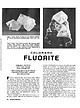 | | Journal (article/letter/editorial) | | 0.75 inch on edge, from the Henderson mine, Clear Creek County. Figure 2 (right). Green fluorite encrusted...Mountain Wilderness area near Columbine Lake, La Plata County; largest crystal measures 1.25 inches on edge;... FLUORITE BARBARA L. MUNTYAN Ouray County Museum Ouray, Colorado 81427 Mineral photographs by John R...locations in Mexico; in Elmwood, Smith County, Tennessee, and in Hardin County, Illinois, in the United States;...eastern Russia. It also occurs in many localities in Colorado, where it is found in colors ranging from pale |  | Eberl, Dennis D., Srodon, Jan, Lee, Mingchou, Nadeau, P. H., Northrop, H. Roy (1987) Sericite from the Silverton caldera, Colorado: Correlation among structure, composition, origin, and particle thickness. American Mineralogist, 72 (9-10) 914-934 | Journal (article/letter/editorial) | | 914-934, 1987 Sericite from the Silverton caldera,Colorado: Correlation among structure, composition,origin...Survey, Federal Center, Mail Stop 404, Denver, Colorado 80225, U.S.A. JIN SnoooN Institute ofGeological...Survey, Federal Center, Mail Stop 963, Denver, Colorado 80225, U.S.A. AssrRAcr "sericite" is a petrographic...the sericites are classifiedas R > 3, mixed-layer illite/smectites that rangein expandability from >4o/oto...deconvolution for a contribution from unarticulated illite particles. A new method for measuringexpandability |  | | Report (issue) | | (Eocene), Cathedral Bluffs area, northwestern Colorado, by J. R. Donnell and A. C. Austin . . . . . ...Clinoptilolite-bearing tuff beds in the Creede Formation, San Juan Mountains, Colo., T. A. Steven and R. E. Van Loenen... 89 98 Mineralogy Clay minerals, Longfellow mine, San Juan County, Colo., by R. G. Luedke and J. W....from hybrid granitoid rocks of the Mount Wheeler mine area, Nevada, by D. E. Lee, R. E. Mays, R. E. Van...gold deposits in the Teton National Forest, Teton County, Wyo., by L. A. Anderson •.•• • • · • • · Reset |  | | Journal (article/letter/editorial) | | occurring in argillaceous sediments, and the term illite, taken from the State of Illinois, is here proposed...must accumulate before the limits of variation oi illite are known, and therefore, before it can be specifically...included in illite into separate specieswith specific names, in which case the term illite may be utilized...found in sediments, the writers favor calling it illite if the material cannot be classedwith recognized...recognized mica speciesand if it is similar to illite. ANarvrtcar, Dara ol frrrrp PunrlrBl lnon L-r.rNors Marpnrer |  | | Report (issue) | | provided, and must be wom at all times while inside the mine gate. - Please keep away from the bench faces. All...used for the mine tour. 11 :00 a.m. Stop 1: Morenci/Metcalf/Northwest Extension overview. Mine overlook (off...Mountain. Lunch at mine overlook. 12:15 p.m. Leave mine overlook area for Morenci mine gate. 12:30 p.m....side of Chase Creek. 1 :00 p.m. Stop 3. Morenci Mine. Medler Ridge area, near the interface between primary...Morenci pit for stop at the Metcalf mine. 2:00 p.m. Stop 4: Metcalf Mine. Leached capping, partial leaching |  | | Report (issue) | | Nevada; Creede, Colorado; Goldfield, Nevada; Guanajuato, Mexico; Lake City, Colorado; Julcani, Peru;...Red Moutain, Colorado; Round Mountain, Nevada; Sunnyside mine, Eureka district, Colorado; Summitvilie...Summitvilie, Colorado; and Tonopah, Nevada. No data were found for the Silver City - De Lamar, Idaho district. The...deposition in the Creede mining district, San Juan Mountains, Colorado: Part IV. Source of fluids from oxygen...5, p. 325. Buchanan, L.J., 1979, The Las Torres mine, Guanajuato, Mexico, ore controls of a fossil geothermal |  | | Journal (article/letter/editorial) | | University, 5500 University Parkway, San Bernardino, CA 92407, USA College of Natural Sciences, California...University, 5500 University Parkway, San Bernardino, CA 92407, USA a r t i c l e i n f o Article history:...include: 1) termite, 2) bat, 3) atmospheric and 4) coal mine fires and natural gas. It is clear that in three...temperatures in coal bed fires is 1.9‰ (Pennsylvania, USA) to 1.7‰ (Germany). © 2014 Elsevier B.V. All rights...for gerhardtite is the United Verde Mine at Jerome, Arizona, USA (Wells and Penfield, 1885), though the |  | | Book | | MINES AND MINERALS OF THE GREAT AMERICAN RIFT (COLORADO-NEW MEXICO) Sine —_—< ¢ te om At _SHT 40...MINES AND MINERALS OF THE GREAT AMERICAN RIFT (COLORADO-NEW MEXICO) Richard Walker Holmes and Marrianna...Mines and minerals of the Great American Rift (Colorado-New Mexico). Bibliography: p. Includes index...index. 1. Mines and mineral resources—Colorado. 2. Mines and mineral resources—New Mexico. I. Kennedy, Marrianna...enter must be obtained to prevent trespass. Old mine workings are dangerous and entering underground |  | | Journal (issue) | | ......... 15 W. E. Wilson The Piedmont mine, Yavapai County, Arizona ............................................. 29 B. L. Muntyan The San Manuel mine, Pinal County, Arizona .............................Alexander The Morenci and Metcalf mines, . Gila County, Arizona ........................................& W. E. Wilson Mineral collecting at the Magma mine, . . Superior, Arizona ..........................Presmyk & M. Hay Treasures of the Magma mine, Pinal County, Arizona ............................... |  | | Book (edition) | | Wu!fenite. Red Cloud mine, Si/County, Arizona. Smithsonian Institution...District, Cochise County 64 The Tombstone District, Cochise County 70 The Mammoth-St. Anthony Mine, Tiger, Pinal...Pinal County 78 Uranium and Vanadium Deposits 80 Monument Valley 81 - • Vll The Cameron Area 85 Breccia...Breccia Pipes 87 Pegmatites 88 "Mine Fire" Minerals, United Verde Mine, Jerome Arizona Meteorites PART... Apache County 435 Cochise County 436 Coconino County 437,438 Gila County 439 Graham County 440 Greenlee |  | | Journal (issue) | | CA Articles Great pockets: the National Belle mine ..................................................T. Rosemeyer Phosphate minerals from the Tip Top mine, Black Hills, South D a k o ta ...................& W. L. Roberts The Stoneham barite locality, Colorado....................................................... 255 by N. L. Bennett The Buca della Vena mine, Tuscany, I ta ly ................................R. Kampf Natural History Museum of Los Angeles County George Robinson National Museums of Canada Arthur |  | | Book (edition) | | Deposits The Bisbee District Tl1e Mammoth-St. Anthony Mine, Tiger 17 17 21 3. Uranium and Vanadium Deposits...The Cameron Area 24 24 27 4. "Mine Fire" Minerals, United Verde Mine 29 5. Arizona Meteorites 31... Wulfenite. Glove mine, Cottonwood Canyon, Santa Rita Mountains, Santa Cruz County. Bandy collection...79 mine, Gila County. Wayne Darby collection. Jeff Kurtzeman. Wulfenite on mottramite. 79 mine, Gila...Gila County. Wayne Thompson collection. Jeff Kurtzeman. - Introduction Since the inception of modern | | | Book (edition) | | Wulfenite. Red Cloud mine, Silver district, Trigo Mountains, La Paz County, Arizona. Smithsonian Institution...District, Cochise County 64 70 The Tombstone District, Cochise County The Mammoth-St. Anthony Mine, Tiger, Pinal...Pinal County Uranium and Vanadium Deposits 80 Monument Valley 81 63 78 il S: The Cameron Area 85...Breccia Pipes 87 Pegmatites 88 “Mine Fire” Minerals, United Verde Mine, Jerome Arizona Meteorites 93 PART...Apache County — 435 Cochise County 436 Coconino County 437, 438 Gila County 439 Graham County Greenlee |  | | Book (edition) | | McDonald Co\·er photo: \\ 7 ulfenite, Rowley Mine, Maricopa County, 4 cm high specimen, Evan and Melissa Jones...gemandmineralmuseum.arizona.edu) is located in the old Pima County Courthouse building at 115 North Church Avenue...on the market. The mines at Bisbee, in Cochise County, have produced large quantities of gem-quality...mineral stamp issued in 1992. At Morenci, in Greenlee County, gem-quality azurite was also commercially recovered...cut parallel to the grain. The Blue Ball Mine, in Gila County, has produced thousands of azurite nodules | | | Book (edition) | | Muineralogy of Arizona Stope in oxide ore, Copper Queen mine, Bisbee. These old workings were probably mined...Deposits The Bisbee District The Mammoth-St. Anthony Mine, Tiger Lee Le 2A 3. Uranium and Vanadium Deposits...The Cameron Area 24 24 Ld 4. “Mine Fire” Minerals, United Verde Mine 29 5. Arizona Meteorites ol... Wulfenite. Glove mine, Cottonwood Canyon, Santa Rita Mountains, Santa Cruz County. Bandy collection... 79 mine, Gila County. Wayne Darby collection. Jeff Kurtzeman. Wulfenite on mottramite. 79 mine, Gila |  | | Book | | Engineers. He did his undergraduate work at the Colorado School of Mines and earned the doctorate from...where no maps were available. In southern Yuma County he even discovered and named a whole new range...southern Yuma County, studies on gold lode and placer deposits, work on the structural geology at San Manuel...COPPER CITIES a MORENCI oe SAFFORD © ILVER SS © SAN MANUEL M 7Jucson PIMAcoMISSION ° ESPERANZA Vie...vein and bed replacements typified in the Magma mine at Superior, Arizona, and the host of small basemetal |  | | Book (edition) | | uranium-vanadium deposits on the vegetation of the Colorado Plateau. H. Cannon L. (1953) Geobotanical...prospecting for uranium on La Ventana Mesa, Sandoval County, New Mexico. .,3d ed. H. C. Dake (1953) The uranium...and J. H. Soule (1955) Uranium ynining on the Colorado Plateau. Jack DeMent and H. C. Dake (1947) Handbook...V. C. Kelley (1955a) Regional tectonics of the Colorado Plateau and relationship to the origin and distribution...currence of uranium and vanadium minerals from the Colorado Plateaus. For maps showing the location of uranium |  | | Report (issue) | | clinoptilolite-rich rocks in Argo drain water at Idaho Springs, Colorado, and related experimental aspects by George A...imply endorsement by the U.S. Government. Denver, Colorado CONTENTS Page Abstract Introduction ............. 12 Exposure of South Dakota CRR to ARD in Colorado and southwestern Spain ........... 15 Copper and...+ Cu + Pb capture versus Ca + K loss for eight Colorado ARD localities and four localities in Huelva Province...exposed to Argo tunnel drain at Idaho Springs, Colorado ....................... 6 Table 3. Relationships |  | | Report (issue) | | Report NPS/NRSS/GRD/NRR—2017/1512 John P. Graham Colorado State University Research Associate National Park...Resource Stewardship and Science Fort Collins, Colorado The National Park Service, Natural Resource...Stewardship and Science office in Fort Collins, Colorado, publishes a range of reports that address natural...NPS/NRSS/GRD/NRR—2017/1512. National Park Service, Fort Collins, Colorado. NPS 372/140095, September 2017 ii Contents...Geologic Resources Division partners with the Colorado State University Department of Geosciences to |  | | Report (issue) | | General Geology of Santa Rita Quadrangle Grant County, New Mexico By WILLIAM R. JONES, ROBERT M. HERNON...Beartooth Quartzite_-__-____ Upper Cretaceous Colorado Formation.__________ Upper Mesozoic (?) and Cenozoic...Geologic map of the Santa Rita quadrangle, Grant County, N. Mex._____________________________ In pocket...Geologic sections of the Santa Rita quadrangle, Grant County, N. Mex___________________________ In pocket Geologic...Copper Flat area, Santa Rita quadrangle, Grant County, N. Mex____ In pocket Index map of New Mexico_ |  | | Book (volume) | | to g ra p h: The Bingham Canyon open pit, Utah, USA, 1998. Photographs by T M Porter. Ross Lang Andrew... La Escondida and El Teniente in Chile, Cerro Colorado in Panama, Grasberg in Indonesia, Sar Cheshmeh...Iran, Cananea in Mexico, and Bingham Canyon in the USA (Clark, 1993). This paper reviews the range o f processes...subduction zones: An example from Simcoe, Washington, USA; Geochimica Cosmochim. Acta, v. 60, pp. 1739-1749...Andean magmatism and its tectonic setting: Boulder, Colorado, Geological Society o f America Special Paper |  | | Report (issue) | | Geological of America, Boulder, INC. Place Colorado Printed in the United States by Edwards Inc...8137-1131-2 Published THE GEOLOGICAL Society Card Colorado Michigan Soctety 80301 48104 The publication...no OIL ORO OIG ZoZ 292 Boulder County Tellurides .... 294 Boulder County Tungsten ...... eeoeeesee 296...e@eeeeeeoe 323 COLORADO PLATEAU (COLORADO-UTAH-NEW MEXICO-ARIZONA) ... 323 A. Rifle area, Colorado «0s... 323...323 B. Uravan District, Colorado 324 Cope tick Rock DIsEEIcL sCoLoradO) sietss) 0001010016 «06 324 DeeGkante |  | | Report (issue) | | --------------Cleburne County ----------~----------------- Tallapoosa County --------------------------Alaska...------------------Cochise County -----------------------------Gila County --------------------------------Greenlee...ee County ----------------------------R[aricopa County ----------------------------R[ohave County --...-----------------------------Pima County -------------------------------Pinal County -------------------------------Santa...-------Santa Cruz County --------------------------'ravapai County -----------------------------'ruma |
|


