 | | Journal (article/letter/editorial) | | New Hampshire Mineral Locality Index Downloaded by [University of Newcastle, Australia] at 15:01 05...entrance and arch of the Palermo mine, North Groton, Grafton County. Rob Lawrence photo, courtesy Bob...Bob Whitmore. 242 ROCKS & MINERALS lthough New Hampshire, the Granite State, is one of our smaller states...reading Jackson (1844) on the mineralogy of New Hampshire that even at this early date there was already...activity produced new localities, renewed some old localities, and resulted in new minerals being discovered |  | | Book (volume) | | in the north. ALEXANDER COUNTY FAYVILLE, area stream gravels⎯agate, jasper, rare alluvial Diamond. THEBES:...the Mississippi R.⎯agate, jasper; d RR siding of Clay⎯agate. CALHOUN COUNTY AREA, shores of the Mississippi...crystals). CRAWFORD COUNTY PALESTINE, area deposits⎯Siderite. EDWARDS COUNTY AREA, T. 1 S, R. 10 E...deposits⎯Siderite. FULTON COUNTY FARMINGTON, W 6 mi. on Rte. 116 to the Rapatee No. 5 strip mine⎯pyritized gastropods...gastropods (Pennsylvanian age). GRUNDY COUNTY AREA: c Regional rd. and RR cuts and banks of Mason Cr.⎯fossils; |  | | Book (volume) | | in the north. ALEXANDER COUNTY FAYVILLE, area stream gravels⎯agate, jasper, rare alluvial Diamond. THEBES:...the Mississippi R.⎯agate, jasper; d RR siding of Clay⎯agate. CALHOUN COUNTY AREA, shores of the Mississippi...crystals). CRAWFORD COUNTY PALESTINE, area deposits⎯Siderite. EDWARDS COUNTY AREA, T. 1 S, R. 10 E...deposits⎯Siderite. FULTON COUNTY FARMINGTON, W 6 mi. on Rte. 116 to the Rapatee No. 5 strip mine⎯pyritized gastropods...gastropods (Pennsylvanian age). GRUNDY COUNTY AREA: c Regional rd. and RR cuts and banks of Mason Cr.⎯fossils; |  | | Book (volume) | | Dahlonega Co. and Rabum Co., and the McDuffie County Belt extending through portions of McDuffie, Warren...Sphalerite. BALDWIN COUNTY MILLEDGEVILLE, at state farmjasper. BANKS COUNTY COMMERCE, along Hwy. 59...along adjoining Co. linerock crystal. BARROW COUNTY WINDER, along rd. to Jefferson and 1½ mi. inside...in the United States BARTOW COUNTY AREA, Saltpeter Cave, as floatjasper. CARTERSVILLE: area barite...cuts, etc.agate, (banded, various colors), jasper. BIBB COUNTY MACON: at Holton Quarry, 7½ mi. NWagate; |  | | Book (volume) | | UNH LIBRARY 3 MbOD DllEE THE GEOLOGY NEW HAMPSHIRE A REPORT COMPRISING THE RESULTS OF EXPLORATIONS...Arrangements have been made upon the scale of Bien, of New York. The execute the coloring. tion with this...I. Page. THE RELATIONS OF THE GEOLOGY OF NEW HAMPSHIRE TO THAT OF THE ADJACENT TERRITORY. By II. ...CLASSIFICATION OF THE By C. H. Hitchcock, INDEX, 634 NEW HAMPSHIRE FORMATIONS. 658 677 LIST OF ILLUSTRATIONS...Geological map illustrating the relation of the New Hampshire formations to those of the adjacent territory |  | | Report (issue) | | of examination as been field the made of new one annual increasing the testify to. investigations...-------------- CHRYSOPRASE 76 ---------------- JASPER 75 OPAL ----------------- ALBITE 78 ----------------...Valley Hydraulic Mine,” in 41 County Amador at Volcano, Flat, Cherokee County 41 Butte 9. showing...Lepidolite Mine, in 7. structure ----- 15 Mountain. Pala surface, showing Weathered Diego County. San...Ramona, Albite, crystallized on 46 County Diego County ---- 47 11. 12. 13. Town of Belfry |  | | Book (volume) | | and Geology Edited by Vandall T. King Walworth, New York 14568 Production editing and design Robert...Extracts from a Diary Concerning Mining at the Dunton Mine, Newry, Maine ....................................Duane L. Leavitt The Bennett Pegmatite, Oxford County, Maine . ........................................in geology and has authored articles on Maine and New England geological and mineralogical occurrences...permanent photographic exhibits in the northeastern USA. The Shaubs have been active in ornithological research |  | | Report (volume) | | series, a geologic name commonly used in the State of New York, is listed under the Canadian province of Ontario...Eodgers, John, 1957, Principles of stratigraphy: New York, John Wiley and Sons, 356 p. Durham, J. W.,...Suggestions in stratigraphic nomenclature: Science, new ser., v. 76, no. 1978, p. 489. Hedberg, H. D., 1948... Biostratigraphic study of Miocene Ostracoda of New Jersey, Maryland, and Virginia: Jour. Paleontology...Canada Pleistocene fChamplain period l (Vermont-New York-Quebec) Iroquois stage * (Great Lakes region) |  | | Journal (issue) | | fo r distribution ; to encourage the search for new minerals that have not yet been discovered; and to...Associat ion by nominating them for membErship? Each new member helps to extend the, Association's activi...tool ) .. ...... .. .. .. ................... 23 NEW ENGLAND NOTES. Conducted by Rudolf C. B. Bartsch... . .. . . .. . . .. 27 CLUB AND SOCIETY NOTES: NEW YORK MINERALOGICAL SOCIETY . . . . . . . . . . ..... .... ..... . .... .... _. . . . . . . . . . . NEW JERSEY MINERALOG ICAL SOCIETY . . . . . . . . . |  | | Report (volume) | | to continue the compilation of geologic names as new names or re.. visions of old names appeared in the...pertinent geologic publications for preparation of a new lexicon. After the review had been brought up to...publish quickly some of the essential data concerning new names that had been published since 1935, the cutoff...Wilmarth Lexicon. Bulletin 1056-A listed about 5,000 new names introduced for use in North America, the Pacific...given in the Wilmarth Lexicon has been replaced by a new usage, which is given in the present lexicon. Thus |  | | Report (issue) | | MURRAY, Cashier Assistant Cashier • Jr. AO N NEW YORK, Agency No. [ 1 Pine Street. 2 Tremont...at Virginia City and Correspondents in all of New Zealand and AUSTRALIA, ^owns National Union...Union National Bank Boatman's Savings Bank NEW ZEALAND. The Bank of California ] BOSTON, CHICAGO, Bank... - . . Agent at Virginia, Nevada, Agents at New Yorlc, 1 62 Wall Street, / - FLOOD, J. L. a....Colonies and New Ze.u-and, andj on Honolulu, Hawaii. NEW YORK BANKERS— The Bank of New York, N. B |  | | Journal (volume) | | f.p. for for:v -" ...THE EN. N o GI "RNAL MINE NI'N NG G. J ou VOLUN/1E JANUARY TO LXIII. .... 191 Alabama, Coal Production, 1896. Aluminum, New Uses..... ........... 632 Abbotl’s Pat. Separator...Aluminum, Prices of.................. 565 Accident Mine, Colo.......... 97 63, 159 Aluminum Reduction, Gooch's...118 Alabama Industrial and Scientific Amador Queen Mine, Cal..... ...... 263 Acetylene Gas, Conner's Pat... Doddridge's Pat...... 487 "Alabama, Johns Coal Mine. 74 Amalgamating Process, FischerAcetylene Gas, |  | | Journal (volume) | | them printed and copies surface, which include the new 40-stamp mill on the forwarded to the members of...hoist and office. The reopening of the old G win mine in Calaveras proposed by the Mining and Scientii-io...Spanish mine is also included putilisiied in the issues of October 31st and November county is an event... shaft, and putting ing properties in Nevada county. There was, when they took charge, up a 40-stamp...and pumping depth and the rig on the ductions mine. stamps Twenty were added late works tons |  | | Book | | M.G., arrived in the Colony, and proclaimed the new Constitution on the 22nd. The Constitution thus secured...‘t0Wn * 18 COnnectcd ^ Eastern 9 Katanning is a new township, about half way between Beverley and Albany...small town on the Avon, about 18 miles South of New¬ castle. It is also connected with Perth by rail...starts from here to the Yilgarn goldfield, also the new road. Physical Geoorapiiy. Western Australia is...broken by isolated sandstone lulls often containing jasper and agate, while the rivers ox pose beds of conglomerate |  | | Journal (volume) | | mountain and Gopher Ridge, in Cala- ; veras county, Cal., lies Salt Spring val- Through this trough-like...is that of the building and head frame at that mine. An electric plant is stalled at La Grange...a 120-stamp mill is also contemplation at this mine. Works, •Cut copyrlghleil by the Union Ii'on S...Patents, 7. EDITORIAL.— A California Contribution; The Mine of Salt Spring Spring Valley, Cal., 1. Coast Gold...greatly exaggerated a chance, even on a rich specimen mine, for it is a well known fact, as proven by experience |  | | Journal (issue) | | Field District 8 Mineral Resources of Trinity County, by Chas. Volney Averill GEOLOGIC BRANCH 8 90...now available is appended hereto, and the names of new bulletins will be added in the future as they are...classes: 1. Mines and mineral resources of a given county or area (describing kind, character, distribution...Engineer MINERAL RESOURCES OF TRINITY COUNTY GEOGRAPHY. Trinity County lies in the northwestern part of California...region. The southwestern corner of the county lies in Humboldt County lies between it and the Pacific the |  | | Report (volume) | | C AL SURVEY BULLETIN 1056-A A compilation of new geologic names of North America, including Greenland...geologic names. Plans made for future compilations as new names and revisions appeared were interrupted during...necessary to furnish a background for preparation of a new edition. After the review was brought up to date...possible, some of the essential data concerning the new names that have appeared since 1935. This compilation...circulation and use. The present work, listing the new names published in the period 1936-1955 and a few |  | | Book (edition) | | to thank all those who assisted in producing this new mining dictionary, especially the Dictionary Revision...transfer to the U.S. Geological Survey. I believe this new dictionary will benefit the Nation by continuing...environment, pollution, automation, health and safety. The new edition of the Dictionary of Mining and Mineral Related...55,000 terms. The 1968 dictionary contained many new mining terms and terms from such related areas as...a list of abbreviations used in the definitions. New terms on marine mining, leaching, and automation |  | | Journal (volume) | | CORRESPONDENCE SOLICITED. STEEL WORKS and Head Office: NEW GLASGOW, N.S THK CAXADIAX -MIXING REV1E:W. in...Quebec Barton St .Sub-bch. Levis (Sub-branch) Toronto New Brunswick Toronto Junction St. John Toronto Junction...Victoria Yukon Terr. Dawson THE UNITED STATES. New^i'ork (52 Wall St.)— W. Lawson and Pictou. ARTHUR...branches .\ustralia— Union Bank of Australia, Ltd. New Zealand Union Bank of Australia, Ltd. India, China...Nova Scotia Steel & Coal Company Ltd. Belmont Gold Mine Ltd. Cape Breton Coal, Iron & Railway Co. Ltd. |
|
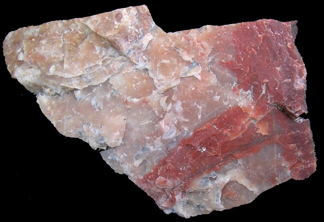


Mine Ledge, Surry, Cheshire County, New Hampshire, USA