 | | Journal (article/letter/editorial) | | sites. ZEOLITES of Washington State Tertiary-age volcanics cover much of Washington State, but only portions...surface of the Columbia River Basalt of eastern Washington is the type locality for paulingite at RUDY...TSCHERNICH 526 A v e n u e A S n o h o m i s h , Washington 98290-2414 T H E VOLCANICS IN T H E PACIFIC...of volcanic rocks and zeolite localities in Washington State. 302 ROCKS & MINERALS CENOZOIC TO RECENT... I n a few exposures in the southern part of Washington, zeolites are found exposed at the base of the |  | | Journal (article/letter/editorial) | | that occur in beautiful specimens in Washington. minerals Washington Mineral Locality Index L A N N Y R...okanoganite-(Y), and zektzerite, all from Washington Pass in Okanogan County —which are known only from the state;...in Snohomish County, ferritungstite from Germania mine near Fruitland in Stevens County, and paulingite...from Rock Island Dam near Wenat chee in Douglas County. In addition, many localities pro duce fine-quality...preparing the alphabet ical list of localities. Chelan County Crown Point mine, near Holden; M O L Y B D E N |  | | Journal (issue) | | .......... VANCOUVER, WASHINGTON May 6, 2000 9:30 am to 6:30 pm Clark County P. U. D. Building 1200...1200 Fort Vancouver Way Vancouver, Washington Rudy will be back meeting with us, so bring your new zeolites...please plan to join us. Mill . Vancouver Way Washington Interstate Bridge Columbia River Oregon 2...SCOLECITE AND MESOLITE AT THE BAIRD CREEK QUARRY, WOLF POINT, COWLITZ COUNTY, WASHINGTON by Rudy W. Tschcmich...Baird Creek, southeast of Wolf Point in the Mount Saint Helens Region of southwestern Washington State |  | | Book | | found between the fibrous zeOlites, natrolite, mesolite, and scolecite because intergrown samples were...gobbinsite), heulandite (clinoptilolite), natrolite (mesolite and scolecite), harmotome (phillipsite and wellsite)... ZEOLITES DEFINED /7 NATROLITE GROUP Natrolite, mesolite, scolecite, tetranatrolite, and gonnardite have...have the same framework. Natrolite, mesolite, and scolecite all have a dominantly ordered framework, with...ANALCIME HARMOTOME NATROLITE LAUMONTTITE SCOLECITE MESOLITE GISMONDINE THOMSONITE HEULANDITE BREWSTERlTE EDINGTONITE | | | Book | | found between the fibrous zeOlites, natrolite, mesolite, and scolecite because intergrown samples were...gobbinsite), heulandite (clinoptilolite), natrolite (mesolite and scolecite), harmotome (phillipsite and wellsite)... ZEOLITES DEFINED /7 NATROLITE GROUP Natrolite, mesolite, scolecite, tetranatrolite, and gonnardite have...have the same framework. Natrolite, mesolite, and scolecite all have a dominantly ordered framework, with...ANALCIME HARMOTOME NATROLITE LAUMONTTITE SCOLECITE MESOLITE GISMONDINE THOMSONITE HEULANDITE BREWSTERlTE EDINGTONITE |  | | Book | | long (Marty, 2004 ). AFRICA widely in Litchfield County, where good crystals were taken from quartz veins...region (Brunet, I 977b ). NEW YORK Amity, Orange County. At many isolated collected sites between the towns...Litchfield County. Ilmenite masses and crystals from somewhere near Washington, Litchfield County, were described...Lake Road occurrence, Faraday Township, Hastings County. In fall 1994, Dan and Shelley Lambert extracted...Madawaska [Faraday] mine near Bow Lake, Hastings County. Some of the world's finest ilmenite specimens |
|
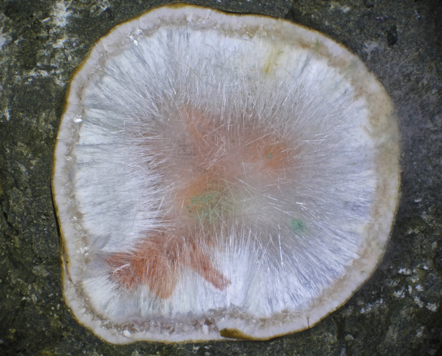


Big Tree Creek, Yacolt, Clark County, Washington, USA