| Classification |
|---|
|
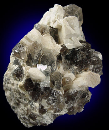
| Species: | Topaz |
| Formula: | Al2(SiO4)(F,OH)2 |
| Colour: | Brown and blue |
Special Storage/
Display Requirements: | Brown is light sensitive |
| Confirmation |
|---|
|
| Validity: | Believed Valid |
| Associated Minerals Based on Photo Data: |
|---|
|
| Albite | ⓘ1 photo of Topaz associated with Albite at this locality. |
| Smoky Quartz | ⓘ1 photo of Topaz associated with Smoky Quartz at this locality. |
| Microcline | ⓘ1 photo of Topaz associated with Microcline at this locality. |
| Data |
|---|
|
| Mineral Data: | Click here to view Topaz data |
| Locality Data: | Click here to view South Baldface Mountain localities, Chatham, Carroll County, New Hampshire, USA |
| Photo Gallery | View Gallery (16 photos) |
| Data Identifiers |
|---|
|
| Mindat Occurrence Record ID: | 47363 |
| Long-form Identifier: | 1:3:47363:1 |
| GUID (UUID V4): | d5f94c2c-215a-456a-b110-b0858175142d |
| Nearest other occurrences of Topaz |
|---|
|
|
| 1.6km (1.0 miles) | ⓘNorth Baldface Mountain localities, Bean's Purchase, Coos County, New Hampshire, USA |
| 10.0km (6.2 miles) | ⓘLord Hill Quarry (Lord Hill Mine), Stoneham, Oxford County, Maine, USA |
| 23.7km (14.7 miles) | ⓘMiddle Moat Mountain locality, Hale's Location, Carroll County, New Hampshire, USA |
| 26.0km (16.2 miles) | ⓘGovernment pit, Albany, Carroll County, New Hampshire, USA |
| 26.4km (16.4 miles) | ⓘLovejoy Gravel pits, Conway, Carroll County, New Hampshire, USA |
| 35.3km (22.0 miles) | ⓘNoyes Mountain Quarry (Harvard Quarry), Greenwood, Oxford County, Maine, USA |
| 35.3km (22.0 miles) | ⓘTamminen Quarry, Greenwood, Oxford County, Maine, USA |
| 35.5km (22.0 miles) | ⓘWaisanen Quarry (Tamminen-Waisanen Quarry), Greenwood, Oxford County, Maine, USA |
| 49.7km (30.9 miles) | ⓘStark, Coos County, New Hampshire, USA |
| 50.1km (31.1 miles) | ⓘBald Mountain, Ossipee, Carroll County, New Hampshire, USA |
| References |
|---|
|
|


South Baldface Mountain localities, Chatham, Carroll County, New Hampshire, USA