 | | Journal (article/letter/editorial) | | 31 December 2014 NEVADA MINERAL STEVEN PULLMAN 1755 Circle Drive NW Reno, Nevada 89509 RICHARD THOMSSEN...THOMSSEN P.O. Box 1656 Carson City, Nevada 89702 Map showing Nevada counties, by William W.Besse. N evada...minerals new to the state being identified every year. Nevada is one of the few western states without a published...'Ike Paao ama, Clark County. Walt Lombard0 specimen, Jeff Scovil photo. Churchill County Chalk Mountain...Mountain District Chalk Mountain mine: calcite, cerussite, chlorargyrite, descloizite, galena, hemimorphite |  | | Report (issue) | | MINERALS OF NEVADA MINERALS OF NEVADA Peer Hen By CASTOR oan eGORY.C.oFER DOCK NEVADA AND BUREAU... UNIVERSITY Reno & Las Vegas OF NEVADA PRESS GEOLOGY Nevada Bureau of Mines and Geology Special...University of Nevada Press, Reno, Nevada 89557 USA Copyright © 2004 by University of Nevada Press Photographs...otherwise noted Map of Mining Districts and significant mineral occurrences of Nevada by Nevada Bureau of Mines...Cataloging-in-Publication Data Castor, Stephen B, Minerals of Nevada / Stephen B. Castor and Gregory C. Ferdock.— Ist |  | | Journal (article/letter/editorial) | | climates. Associated secondary minerals include chrysocolla, malachite, azurite, mimetite, wulfenite, cerussite...Similarly, it is reported from the Perkiomen mine, Montgomery County, Pennsylvania (Gordon 1922). An unusual...cuprite, chrysocolla, and planchtite is described in ore from the Algomah mine, Ontonagon County, Michigan...Michigan (Williams 1962). In the arid mining districts of western states, dioptase is somewhat widespread...from the Santa Rita district, Grant County, and the Orogrande district, Otero County, New Mexico. Dioptase | | | Report (issue) | | MINERALS OF NEVADA MINERALS OF NEVADA STEPHEN B. CASTOR and G R EGOR Y C . F E R D OC K l NEVADA BUREAU...association with the UNIVERSITY OF NEVADA PRESS Reno & Las Vegas Nevada Bureau of Mines and Geology Special...University of Nevada Press, Reno, Nevada 89557 USA Copyright© 2004 by Uni versity of Nevada Press Photographs...Districts and si gnificant minernl occurrences of Nevada by Nevada Bureau of Mines and Geology All rights reserved...-Publ ication Dat,i Castor, Stephen B. Minerals of Nevada/ Stephen B. Castor and Gregory C. Ferdock.- rst | 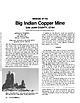 | | Journal (article/letter/editorial) | | Copper Mine Downloaded by [North Carolina State University] at 23:01 15 March 2015 SAN JUAN COUNTY, UTAH...INDIAN COPPER MINE is an open-pit copper mine located within the Big Indian mining district in San Juan...Juan County, Utah, approximately 33 miles northwest of Monticello and about the same distance southeast of...of Moab. The mine has been a noted source of exceptionally fine specimens of azurite rosettes and clusters...from the locality were labeled as coming from the Blue Grotto prospect. Later, from 1982 through 1984, |  | | Journal (article/letter/editorial) | | ~ ) : • ,- '1-/Challis r--, - qa'wtooth Mountains r i ~ Elmore'~. -C- -J'-,/,_~, ~ l I ...specimens, are either inaccessible or are in closed mining districts, or are closed for political reasons...Jerome I i,J--..s.. ,c., --1. I Blaine '-\ [ Clark,-J t: _Buue-J Ketchum Camas '-; :-.... J. •...City-D~Lamar Mining Dlstricts / J\. I,' -r-, - L..... ~ rl.. kl \ , 50 I 100 I Miles old mining and...May 199I-the right to collect in the Sawtooth Mountains of south-central Idaho. Although known by a few |  | | Report (issue) | | MINERAL DEPOSITS IN THE UBEHEBE PEAK QUADRANGLE INYO COUNTY, CALIFORNIA SPECIAL REPORT 42 UNIVERSITY OF...MINES 1-A. Sierra Blanca limestone in Santa Barbara County, California, by George W. Walker. 1950. 5 pp.,...25$. 3. Commercial "black granite" of San Diego County, California, by Richard A. Hoppin and L. A. Norman...of the San Dieguito pyrophyllite area, San Diego County, California, by Richard H. Jahns and John F. Lance...21 figs. Price 50$. 5. Geology of the Jurupa Mountains, San Bernardino and Riverside Counties, California |  | Wrucke, C.T., Marsh, S.P., Raines, G.L., Werschky, R.S., Blakely, R.J., Hoover, D.B., McHugh, E.L., Rumsey, Clayton M., Gaps, R.S., Causey, J.D. (1984) Mineral resources and mineral resource potential of the Saline Valley and Lower Saline Wilderness Study Areas, Inyo County, California. Open-File Report Vol. 1984 (84-560) US Geological Survey doi:10.3133/ofr84560 | Report (issue) | | Valley and Lower Saline Wilderness Study Areas Inyo County, California Chester T. Wrucke, Sherman P. Marsh...Valley and Lower Saline Wilderness Study Areas Inyo County, California by Chester T. Wrucke, Sherman P. Marsh...Valley and Lower Saline Wilderness Study Areas, Inyo County, California................................ In...117A), California Desert Conservation Area, Inyo County, California. SUMMARY The Saline Valley Wilderness...located in eastern California between the Inyo Mountains and Death Valley, were studied in 1981-83 using |  | | Journal (issue) | | OURAY, COLORADO 6 Howard Neal GOODIES AT GOODSPRINGS 8 Mary Frances Strong TARANTULA! 12 Timothy...three states. Bisbee and the fabled Copper Queen mine were responsible for its primary construction. Volume...Myrick's Railroads of Nevada and Eastern California Vol. 7, and Railroads of Nevada and Eastern California...to form the Sunset Route. This gave impetus to mining and agriculture and in turn intensified the construction..." In the Ute language the word meant "hot water spring." Long before any white man set his eyes upon the |  | | Book (edition) | | ice, every blood red glow, every touch of green, blue, gold or royal purple. Gem stones have been the...fortifi- material by rely on color sapphires blue. all six or eight different gem as color, ... its tourmaline may B are, in fact, A blue gem minerals. turn up even two or three colors...associated with such rocks. Because hard rock mining amateur will usually get is tedious and expensive...feldspar quarries in pegmatite deposits, mines and mine dumps, and from "float" deposits, minerals loose |  | | Journal (issue) | | by W. E. Wilson Pink amethyst from the El Choique mine, Patagonia, Argentina ............................Oteiza The Copper World and Mohawk mine, Northeastern San Bernardino County, California ....................WULFENITE, 11.5 cm, from the Jianshan mine, Ruoqiang County, Kuruktag Mountains, Bayinguoling Autonomous Prefecture...with Mimetite, 1.7 cm, from the Rowley mine, Maricopa County, Arizona. Wish Wang collection and photo...$324/three years, (Canada) $186/one year, (outside USA other than Canada) $265 for one year Subscription |  | | Report (issue) | | COPPER. THE YERINGTON COPPER DISTRICT, NEVADA. By FREDERICK LESLIE RANSOME. INTRODUCTION. The town of...of Yerington is in Lyon County, in that part of western Nevada which lies between Tahoe and Walker lakes...River and containing at its upper end the Ludwig mine and the prospecting camp of Buckskin. 0 Smith, D...Geology of the upper region of the main Walker River, Nevada: Bull. Dept. Geol. Univ. California, vol. 4, 1904...is printed Slng-ats-e in this paper. "Geology of Nevada south of the fortieth parallel: Bull. U. S. Geol |  | | Book (edition) | | Wu!fenite. Red Cloud mine, Si/district, Trigo Mountains, La Paz County, Arizona. Smithsonian Institution...Montgomery collection; collected by Ed Over. Chip Clark photo. ' INERALOGY OF A ZONA THIRD EDITION John...and Second Editions PART 2 HISTORY OF ARIZONA MINING AND MINERALOGY The Prehistoric Period 20 Arizona...Deposits 63 The Bisbee District, Cochise County 64 The Tombstone District, Cochise County 70 The Mammoth-St...Mammoth-St. Anthony Mine, Tiger, Pinal County 78 Uranium and Vanadium Deposits 80 Monument Valley 81 - • Vll | | | Journal (issue) | | by WE. Wilson Pink amethyst from the El Choique mine, Pata gonia, Argenti na ..........................2020 The Copper World and Mohawk mine, Northeastern San Bernardino County, California ....................WULFENITE, 11.5 cm, from the Jianshan mine, Ruoqiang County, Kuruktag Mountains, Bayinguoling Autonomous Prefecture...with Mimetite, 1.7 cm, from the Rowley mine, Maricopa County, Arizona. Wish Wang collection and photo...$324/three years, (Canada) $196/one year, (outside USA other than Canada) $275 for one year Subscription | | | Book (edition) | | Wulfenite. Red Cloud mine, Silver district, Trigo Mountains, La Paz County, Arizona. Smithsonian Institution...Montgomery collection; collected by Ed Over. Chip Clark photo. MINERALOGY OF ARIZONA THIRD EDITION W...and Second Editions PART 2 HISTORY OF ARIZONA MINING The Prehistoric Period 20 Arizona Under Spanish...Deposits The Bisbee District, Cochise County 64 70 The Tombstone District, Cochise County The Mammoth-St.... Anthony Mine, Tiger, Pinal County Uranium and Vanadium Deposits 80 Monument Valley 81 63 78 il S: |  | | Report (issue) | | prospects of the Tyrone stock and vicinity, Grant County, New Mexico By D. C. Hedlund 1 Open-File Report...of the quartz-pyrite veins of the White Signal district............................... Quartz-molybdenite.... Quartz-pyrite veins, including White Signal district............... Silver-lead-manganese oxide veins...prospects of the Tyrone stock and vicinity, Grant County, New Mexico.......................... in pocket...in the Tyrone area of the Big and Little Burro Mountains of southwestern New Mexico. Geologic and aeromagnetic |  | | Book (edition) | | McDonald Co\·er photo: \\ 7 ulfenite, Rowley Mine, Maricopa County, 4 cm high specimen, Evan and Melissa Jones...used mining districts as part of the locality description. These political and geographic district names...with a more descriptive term, metallic mineral district. This term shows the geochemical and mineralogical...reader to learn more about the geology of the district and to possibly predict the minerals that could...districts. Where possible, the metallic mineral district for each mineral locality is given for the mineral |  | | Book (edition) | | his co-authors. A graduate of Michigan College of Mining and Technology (now Michigan Technological University)...a men1ber of the faculty of Michigan College of Mining and Technology for three years, leaving that position...become mineralogist for Silver King Mines, Inc., in Nevada. In 1965 he joined Phelps Dodge Corporation as...noted for con1puter applications in geology and mining engineering. The authors and publisher express...permission to reproduce the Map and Index of Arizona Mining Districts. Carleton B. Moore, Peter R. Busek, and |  | | Report (volume) | | most important were those in the Central City district, Colorado, from which about 300 tons of high-grade...Silver Cliff mine, Wyoming; the Jesse D No. 1 and No. 2 claims, Utah; and the Merry Widow mine, New Mexico...Buckhorn claims, Nevada; the Midnite and Daybreak mines, Washington; the W. Wilson mine, Montana; the White...White King mine, Oregon; the deposits in the Pryor Mountains 327 328 SELECTED BIBLIOGRAPHIES OF URANIUM...Wyoming, and the deposits in the Dripping Spring quartzite, Gila County, Ariz. According to Nininger (1954, | | | Book (edition) | | Muineralogy of Arizona Stope in oxide ore, Copper Queen mine, Bisbee. These old workings were probably mined...his co-authors. A graduate of Michigan College of Mining and Technology (now Michigan Technological University)...a member of the faculty of Michigan College of Mining and Technology for three years, leaving that position...become mineralogist for Silver King Mines, Inc., in Nevada. In 1965 he joined Phelps Dodge Corporation as...noted for computer applications in geology and mining engineering. The authors and publisher express |  | | Report (volume) | | ....................................... 102 District of Columbia ............................................................................ 187 Nevada..................................................to refer to Geological Survey Bulletin 507, "The mining districts of the western United States," and to...abundant it may have been completely exhausted by mining or quarrying. Deposits of minerals that are widely...because they occur in sufficient quantity to warrant mining for their usual products, but because they furnish |  | | Book (volume) | | ...........................................283 Nevada ................................................................548 Table of Maps Page Alabama County Map ...................................................................................4 Alaska County and Stream Map ..................................Co. Mining Districts ............................................................22 Arizona County Map.........................23 Arizona – Cochise Co. Mining Districts .................................... |  | | Report (issue) | | predecessor organization, the Manhattan Engineer District ; and, to a lesser extent, by staff members of...United States. The pre-1940 history of uranium mining and geology is concerned largely with veins in...Sierra Ancha region, Arizona ; and the Marysvale district, Utah. All the Western States, including Arizona...Arizona, California, Colorado~ Idaho, Montana, Nevada, New Mexico, and FRANK W. OsTERWALD Oregon, Utah...comments on the history of uranium geology and mining. The other chapters deal principally with pertinent |  | | Book (volume) | | ...........................................243 Nevada .................................................rights, so remember you were told. If in doubt, a county map will tell you who the legal owner is. Good...gemmy qualities for cutting and polishing. AUTAUGA COUNTY PRATTVILLE, N. 6 mi., and just E of the Birmingham...were well known to prehistoric Indians.) BARBOUR COUNTY BAKER HILL, SE 1 mi. : 1 in a deep ravine, as a...deep red to variegated⎯ocher. BIBB COUNTY GENERAL AREA: c county gravel pits along the Cahaba R.⎯gemmy |  | | Book (volume) | | ...........................................243 Nevada .................................................rights, so remember you were told. If in doubt, a county map will tell you who the legal owner is. Good...gemmy qualities for cutting and polishing. AUTAUGA COUNTY PRATTVILLE, N. 6 mi., and just E of the Birmingham...were well known to prehistoric Indians.) BARBOUR COUNTY BAKER HILL, SE 1 mi. : 1 in a deep ravine, as a...deep red to variegated⎯ocher. BIBB COUNTY GENERAL AREA: c county gravel pits along the Cahaba R.⎯gemmy |
|


Blue Jay Mine, Goodsprings Mining District, Spring Mountains, Clark County, Nevada, USA