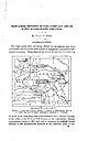
 | | Report (issue) | | MANGANESE DEPOSITS OF THE CADDO GAP AND DE QUEEN QUADRANGLES, ARKANSAS. By HUGH D. MISER. INTRODUCTION...being offered for manganese ores have stimulated interest in the little-exploited manganese deposits of westcentral...westcentral Arkansas. These deposits are found at intervals in a belt 4 to Scale zs so Miles FIGURE...quadrangles, Arkansas and Oklahoma. 12 miles wide, extending west-southwestward from Pulaski County, at the...the center of the State, to Polk County, on the west border. Eecent exploitation, begun in 1915 and still |  | | Journal (article/letter/editorial) | | crystals, Arkansas also boasts an array of other minerals, as evidenced by this county-by-county description...R K A N S A S H A S A R I C H M I N E R A L and mining heri tage that started in the early 1800s with...of Magnet Cove, continued with mining in north ern and western Arkansas and Magnet Cove during the Civil...extensive collecting in Magnet Cove. In the 1900s, mining and minerals continue to play important roles in...the state, with obvious peaks in exploration and mining having occurred during World Wars I and I I . |  | | Report (issue) | | Warsou, pn. D. DIRECTOR Bulletin No. XVII Manganese Deposits of the West Foot of the Blue Ridge, Virginia...description Psilomelane lq 42 tq /2 Manga,rrite Pyrolusite Wad . Limonite Other minerals.... Relations...Creek or Seibel mine .. iocation geology ore Millins Vicinityof X'rontRoyal County BentonvilletoVauEhanStation...BentonvilletoVauEhanStation Dry Run or Compton mine. . . Bailey prospect .. . . Minei Run bank . Page Prospects near...Prospects near Elgin Viciriity of Marksiille Eureka mine . Area southwest of Stanley Mines and prospects |  | | Report (volume) | | SURVEY GEORGE OTIS SMITH, DIRECTOR BULLETIN 427 MANGANESE DEPOSITS. OF THE UNITED STATES WITH SECTIONS ON...CHAPTER I. SOURCES OF MANGANESE ...................................... Manganese ores...................Table of manganese minerals....................................... 13 17 17 17 19 19 20 Manganese in the................................... CHAPTER II. MANGANESE DEPOSITS OF THE UNITED STATES. ............................................... Origin of the manganese ores of the Piedmont region................. Commercial |  | | Report (issue) | | and Duncan mining districts, Grant and Hidalgo Counties, New Mexico, and Greenlee County, Arizona By..... Mining districts, mines, and mineralization............................. Steeple Rock district......subdistrict................................... Duncan district...................................................... Generalized geologic map of the Summit Mountains and Canador Peak areas..........................Generalized Cenozoic stratigraphic sections, Summit Mountains-Canador Peak-Redrock Canyon areas, New Mexico |  | | Report (issue) | | Werson, Pn. D. DIRECTOR Bulletin No. XXIII Manganese Deposits of Western Virginia BY G. W. STOSE... lo Manganese ore deposit Mining and preparation of St. Lukes Hospital tract .. Godlove mine .. /d...Workings Geology ..: .. . . 8t 82 83 Manganese ore deposit Mining and preparation of Rhesa A. Orndorff...prospect 86 86 86 88 88 89 92 92 93 93 93 Capola Mountain lnine Little North Moulfain prospect Liberty...Springs prospects Gap Mountain prospect Scott prospect .. . . . Powells Fort mine Location and geography |  | | Report (volume) | | Director Bulletin 940-H MANGANESE DEPOSITS OF THE FLAT TOP AND ROUND MOUNTAIN DISTRICTS BLAND AND GILES.................................. Plat Top Mountain district............................... Structure............................................... Manganese deposits................................... Reserves...mines............................ Geology and manganese deposits............... Production....................... Dismal Creek mine. .............................. Silver Creek mine ...................... |  | | Report (issue) | | have been considerable prospecting and mining in the district and notable advances have been mad.e in...folds at Cripple Creek_______Folds of the Lick Mountain area_________ Warping south and west of Sugar...43 Laswell overthrust Hematite Mountain overthrust Dry Pond Mountain and periwinkl. vtl 43 43 44 _...Thrust faulting between Austinville and Poplar Camp Mountain--Gray's School thrust -------------------Other...area-----Ewing Mountain overthrust Sand Mountain and Henley Mountain overthrusts---------------Lick Mountain klippe |  | | Report (volume) | | 50. II. Tertiary History of the G-rand Caiion District, with atlas, by Clarence E. Dutton, Capt. U. S... Geology of the Comstocls Lode and the Washoe District, with atlas, by George F. Becker. 1882. 4°. xv...of 21 sheets folio. Price $11.00. IV. Conistock Mining and Miners, by Eliot Lord. 1883. 4°. xiv, 451 pp...Price $1.20. VIII. Paleontology of the Eureka District, by Charles Doolittle Walcott. 1884. 4°. xiii...46 pi. and maps. Price $1.75. XII. Geology and Mining Industry of Leadville, Colorado, with atlas, by |  | | Book (edition) | | them not hitherto or elsewhere discovered The Mica mining industry, for example, has brought to a Pi 7...kerrite, culsagerite, Among (all number of rare mountain reminerals, and these are maconite, lesleyite...public, for the benefit of all discoveries in the mountains, have amateurs and students, who are continuing...York, has spent many months in explorations and mining for these mineral rarities, and has himself added...B. boring gold region. for notes of the mica mining And to Prof. A. A. Julien the survey occurrence |  | | Book | | 265 274 Vermiculite 145 Magnesite & magnesia Manganese minerals 255 Titanium & zirconium minerals ...in this book. More than 90% of manganese goes into steel, but manganese also has dozens of nonmetallic...boundaries of the mineral industry are clear: the mining and milling of feldspar, for example, belong to...does not. But how does one draw the line between mining and manufacturing where brine from a salt well...districts, or a representative district if there are many. We name the chief mining companies, and give production |  | | Report (volume) | | Bulletin nos. 26, 27; Museum Paper no. 7; County Report no. 1 (Clay County). Montgomery, Ala. Alberta, Scientific...Geologists: Bulletin, vols. 7, 8. American Institute of Mining and Metallurgical Engineers: Transactions, vols...Mineralogist, vols. 8, 9. Menasha, Wis. American Mining Congress: Reports of 25th and 26th Annual Conventions...nos. 1-28. San Francisco, Calif. California State Mining Bureau: Bulletin, nos 91-93. San Francisco, Calif...vols. 37, 38. Ottawa, Ont. Canadian Institute of Mining and Metallurgy: Transactions, vols. 25, 26; Monthly |  | | Report (volume) | | Notes on the gold lodes of the Carrville district, Trinity County, Cal., by D. F. MacDpnald...............account of the ore deposits of the Loon Creek district, Idaho, byJ. B.Umpleby..........................Antelope district, Nev., by F. C. Schrader................... Notes on the northern La Sal Mountains, Grand...Grand County, Utah, by J. M. Hill. Survey publications on gold and silver..................................... COPPER: The Turquoise copper-mining district, Ariz., by F. L. Ransome........... Survey publications |  | | Report (issue) | | C. A. Michael. COLD NUGGET FROM SPOTSYLVANIA COUNTY: Longest dimension approximately 13 cm., photograph...updated “check list” just alluded to, (2) a county-by-county listing of the minerals, and (3) resumes of...(Turgite) Ilmenite Rutile (Leucoxene) 4 Checklist Pyrolusite (Varvicitc) Wad (Lampaditc) (Lirhiophorirc) Rancicitc...(Haydcnitc) 9 Virginia Mineral Localities by County This list is included for possible aid in planning...listed only* if localities arc given for them. The county lists do not include com mon rock-making materials |  | | Report (volume) | | Ferguson.. Mineral resources of the Inyo and White mountains, California, by Adolph Knopf............................... Copper deposits of the White Mesa district, Ariz., by J. M. Hill............ Survey publications...the Dome district, Idaho, by J. B. Umpleby.... The Yellow Pine mining district, Clark County, Nev., by...zinc.................................. IRON AND MANGANESE: Preliminary report on the red iron ores of east............... Survey publications on iron and manganese ores........................ ALUMINUM ORES: Alunite |  | | Book (edition) | | who have been engaged in the study of our great mining regions, especially in the West, have laid the...now in the active practice of the profession of mining engi neering. J. F. K. DECEMBER, 1899. NO TEXT...125-129; Marquette district, 129-136; Menominee dis trict, 136-139; Penokee-Gogebic district, 139-143; Vermilion...11, Pilot Knob, Mo., 155-157; Example lla, Iron Mountain, Mo., 157, 158; analyses of hematites, 159.. 114-159...and Sterling, N. J., 251-257; Zinc in the Rocky Mountains, 258, 259: in New Mexico, 259 250-259 CHAPTER |  | | Report (volume) | | Western Sierra C:ourlty, New Mexico, Suggested by Mining Distri.cts, Ceologyt and c ·eochemicaf, Anomalies... Mineral Belts in Western Sierra County, New Mexico, Suggested by Mining Districts, Geology, and Geochemical...information on mineral belts in western Sierra County, New Mexico, indicates many new areas favorable...1921Mineral belts in western Sierra County, New Mexico, suggested by mining districts, geology, and geochemical...resources-New Mexico-Sierra County. 2. Geology-New Mexico-Sierra County. I. Heyl, Allen Van, 1918- II |  | | Report (issue) | | prepared during the last 20 years by geologists and mining engineers of the U.S. Geological Survey and the...E. Williams ...... . ............. . Dragoon Mountains Roadless Area, Arizona, by Harald Drewes and T...Drewe and P. R. Bigsby .................. . Pine Mountain Wilderness , Arizona, by Frank C. Canney and Frank... . . . . . . . . . . . . . . . . . . . . . 39 Arkansas . . . . . . . . . . . . . . . . . . . . ............. Bell Star East and West Roadless Areas, Arkansas, by Mary 43 H . Miller and Lyle E. Harris . . |  | | Report (volume) | | Manganese Contents of Some Sedimentary Rocks of Paleozoic Age in Virginia By ERIC R. FORCE and LESLIE...LESLIE j. COX A. Manganese Contents of Some Lower Paleozoic Carbonate Rocks of Virginia, by Eric R. Force...Force B. Manganese Contents of Some Rocks of Silurian and Devonian Ages in Northwest Virginia, by Leslie...Cataloging in Publication Data Force, Eric R. Manganese contents of some sedimentary rocks of Paleozoic...Virginia~Analysis. 2. Geology, Stratigraphic~ Paleozoic. 3. Manganese ores~Geology~Virginia. I. Cox, Leslie j. II. Title |  | | Report (volume) | | report on Park City mining district, Utah, by J. M. Boutwell_ 41 Placer gold mining in Alaska in 1902,...by Alfred H. Brooks 49 The Glenn Creek gold-mining district, Alaska, by Arthur J. Collier_ _ Gold and pyrite...pyrite deposits of the Dahlonega district, Georgia, by Edwin 57 C. Eckel_ _ 64 Neocene rivers of the...field, Alaska, by Walter C. Mendenhall . 76 Gold mining in central Washington, by George Otis Smith Ore...by J. E. 81 Spurr Gold mines of the Marysville district, Montana, by Walter Harvey 88 Weed 90 List of |  | | Report (volume) | | from Leopold Vista, Catron County, N. Sheridan Gulch, (5) Sheridan Mountain, (6) Big Dry Creek, (7) Black...Haystack Mountain, (13) Shelley Peak, (14) Bursum caldera, which passes through Nabours Mountain, Sheridan...Sheridan Mountain are on the resurgent dome of the caldera. Mex. (1) Nabours Mountain, (2) Wilcox Peak,...(3) Holt Mountain, (4) Mountain, (8) Crown Mountain, (9) West Baldy, (10) Sacaton Mountain, Seventyfour...Seventyfour Mountain. Most of view is of the ring dike zone of the Mountain, and Haystack Mountain; Black Mountain |  | Ratte, James Clifford, Gaskill, D.L., Eaton, G.P., Peterson, D.L., Stotelmeyer, R.B., Meeves, H.C. (1972) Mineral resources of the Gila Primitive area and Gila Wilderness, Catron and Grant Counties, New Mexico. Open-File Report Vol. 1972 (72-306) US Geological Survey doi:10.3133/ofr72306 | Report (issue) | | Vista, Catron County, N.Mex. (1) Nabours Mountain, (2) Wilcox Peak, (3) Holt Mountain, (4) Sheridan Gulch...Gulch, (5) Sheridan Mountain, (6) Big Dry Creek, (7) Black Mountain, (8) Crown Mountain, (9) West Baldy,... (10) Sacaton Mountain, (11) Little Dry Creek, (12) Haystack Mountain. IN REPLY REFER TO: UNITED STATES...Canyon------------------ 63 Volcanic complex of Alum Mountain--------------- 64 Latitic·and andesitic flows...Spring----------------------------- 82 Rhyolite of Sacaton Mountain---------------------- 89 Mineral Creek And |  | | Journal (volume) | | f.p. for for:v -" ...THE EN. N o GI "RNAL MINE NI'N NG G. J ou VOLUN/1E JANUARY TO LXIII. ...YORPQ. : - . - ". • : THE ENGINEERING AND MINING JOURNAL. VOLUME LXIII. JANUARY TO JULY, 1897...Aluminum, Prices of.................. 565 Accident Mine, Colo.......... 97 63, 159 Aluminum Reduction, Gooch's...118 Alabama Industrial and Scientific Amador Queen Mine, Cal..... ...... 263 Acetylene Gas, Conner's Pat... Doddridge's Pat...... 487 "Alabama, Johns Coal Mine. 74 Amalgamating Process, FischerAcetylene Gas, |
|


