 | | Corporate Document | | 2012 Copper King Mine, Silver Crown District, Wyoming (Preliminary Report) W. Dan Hausel Independent...Gilbert, Arizona 11/14/2012 COPPER KING MINE, SILVER CROWN DISTRICT W. Dan Hausel, Independent Geologist...Geologist Gilbert, Arizona Introduction The Silver Crown district (also known as Hecla) lies 20 miles west of...Park along the eastern flank of the Laramie Range. The district is visible on Google Earth (search for...Cheyenne, WY’) and lies within the boundaries of the Laramie 1:100,000 sheet. This area was initially investigated |  | | Report (issue) | | THE GEOLOGICAL SURVEY OF WYOMING Gary B. Glass, Executive Director and State Geologist ADVISORY BOARD...University of Wyoming Donald B. Basko, Oil and Gas Supervisor Appointed D.L. Blackstone, Jr., Laramie Michael...Cheyenne, Wyoming. This and other publications available from: The Geological Survey of Wyoming P.O. Box...University Station LaIanlle, Wyoming 82071 (307) 766·2286 Front Cover - Wyoming gold. Gold buttons in the...recovered by Dean Farris from mine dump waste in the Gold Hill district. The actual diameter of the button |  | | Book (volume) | | Iowa to 3,500’ along the western boundary with Wyoming. In the far western counties of Lawrence, Meade...instance, a single Spodumene crystal from the Etta Mine near Keystone on the east side of the Mount Rushmore...commercial production of minerals, principally Gold, Silver, Copper, Iron, Lead, Manganese and Zinc, along...beds, excavations, etc.Selenite roses. BRULE COUNTY AREA: in the Oacoma zone of the Pierre Fm. On Elm...gray Barite rosette up to 5 or 6 inches. CAMPBELL COUNTY MOUND CITY, W to the Missouri R., regional hillsides |  | | Report (issue) | | 31 University of Nevada Press, Reno, Nevada 89557 USA Copyright © 2004 by University of Nevada Press Photographs...copyright © 2004 unless otherwise noted Map of Mining Districts and significant mineral occurrences of...Olivenite, 1.6-cm cluster, Majuba Hill Mine, Antelope district, Pershing County. N. Prenn collection. Photograph...production of environmental protection equipment. Mining and the discovery, identification, and development...to Nevada in 1929 and was actively involved in mining in the state and the western U.S. for the rest |  | | Book (edition) | | thrilled to the sight of mounted in gold or or silver, some lovely gem, against lying a background...associated with such rocks. Because hard rock mining amateur will usually get is tedious and expensive...feldspar quarries in pegmatite deposits, mines and mine dumps, and from "float" deposits, minerals loose...should always ask permission it may be un- or a mine dvmip. Cleanliness around a camp site and removal...recent perhaps because of the decline in placer mining for gold in made dis- faces helps to distinguish |  | | Journal (article/letter/editorial) | | specimens, are either inaccessible or are in closed mining districts, or are closed for political reasons... '<, • Boise I Dismal SW!fP \.J. Silver City-D~Lamar Mining Dlstricts / J\. I,' -r-, - L........ ~ rl.. kl \ , 50 I 100 I Miles old mining and geologic data have not been recently prospected...scientific significance. In this index, the better known mining districts that have produced many high-quality...across, on blue thomsonite. Lucky Peak Dam, Ada County; Lanny Ream specimen and photo. Figure 3 (below) |  | | Report (issue) | | Gold-Silver Veins ........................................ Quartz-Alunite Epithermal Gold-Silver Veins....................... THE LUCKY BOY AND PAMLICO MINING DISTRICTS: A COMPARATIVE STUDY by Daniel R. Shawe...Boy mining district ...................................................... Pamlico mining district .....Boy mining district ...................................................... Pamlico mining district .....map of the Lucky Boy mining district 2. Geologic map of the Pamlico mining district ABSTRACT Mineral |  | | Book | | PISTOLS i !?' A J.-. N ; 'jxt . 1 — \ MINING DISTRICTS and MINERAL RESOURCES of NEVADA by ...present authentic infor mation concerning the mining districts and mineral resources of Nevada. No comprehensive...United States Geological Survey in 1912. Plan. “Mining Districts and Mineral Resources of Nevada”, as...parts:—one on mining districts and the other on mineral resources. The section on mining districts is...but gives more extended descriptions and includes mining as well as geological information. The map which | | | Report (issue) | | 3i University of Nevada Press, Reno, Nevada 89557 USA Copyright© 2004 by Uni versity of Nevada Press Photographs...te, r.6-cm cluster, Majuba Hill Mine, Antelope district, Pershing County. N. Prenn coJlection. Photograph...percent of the state. Nevada's public lands offer mining, livestock grazing, wild horse viewing, .scenic...Road and Geologic Tours in th<' Las Vegas Area. Mining and the discovery, identification, and development...Vavis The Goodsprings (Yellow Pine) Mining District, Clark County John C. Kepper MINERAL CATALOG 91 |  | | Report (volume) | | the State lists begin with Alabama and end with Wyoming. Under each State the minerals found there are...it helpful to refer to Survey Bulletin 507, "The mining districts of the western United States," and to...abundant, it may have been completely exhausted by mining or quarrying. Deposits of minerals of wide distribution...because they occur in sufficient quantity to warrant mining for their usual products but because they furnish...Wisconsin.........Prof. W. 0. Hotchkiss, Madison. Wyoming.........Mr. C. E. Jamison, Cheyenne. Those members | 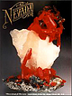 | | Journal (issue) | | B & B mine, Esmeralda County CALIFORNIA: burnt ore dump, Oceanic mine, San Luis Obispo County TEXAS:...TEXAS: Chisos furnace, Terlingua district, Brewster County The Texan material was used in the initial X-ray...Museum. The mineral is named for Curt N. Schuette, a mining geologist who specialized in mercury deposits....Locality: Belmont, Nye County Further analysis of the type material showed it to be the silver analogue of bindheimite...August Stetefeldt (1838-1896), a German-American mining engineer. References: RIOTTE, E. N. (1867) Stetefeldit |  | | Report (issue) | | . . . . . . . . . . . . . . . . . 1 Chapter I. Mining Districts of Counties and the State of Utah. .... . . . . . . . . . . . . . . . . . . . . . . 1 County Listings. . . . . . . . . . . . . . . . . . . ... . . . . . . . . . . . . . . . . 1 Chapter II. Mining Districts of Utah . . . . . . . . . . . . . . .... . . . . . . . 4 Mineral Localities Listed by County . . . . . . . . . . . . . . . . . . . . . . . .... . . . . . . . . . . . . . . . . . . 7 Beaver County . . . . . . . . . . . . . . . . . . . . . . . |  | | Book (edition) | | YEAR 1687"—DAVID T. DAY, CHIEF OF THE DIVISION OF MINING STATISTICS AND TECHNOLOGY WASHINGTON GOVERNMENT...and consump tion, or better and cheaper means of mining, extraction, and convey ance to market, may in...correspondence has been carried on with geologists, mining engineers, and other local authorities, and various...mmed at Broken Arrow aud Trout creek, in Sc. Clair county. The strata in this field are more faulted und...prong of Canoe creek, in St. Clair county, to Ha\sop creek, in Bibb county, a distance of 60 miles. Down to |  | | Journal (article/letter/editorial) | | Clark County. Walt Lombard0 specimen, Jeff Scovil photo. Churchill County Chalk Mountain District Chalk...Chalk Mountain mine: calcite, cerussite, chlorargyrite, descloizite, galena, hemimorphite, leadhillite,...scheelite, vanadinite, wulfenite Corral Canyon District Various mines and prospects: anatase, rutile,...Quartz, 14.2 cm across, Newbeny Mountains,Clark County. Steve Scott specimen, Jeff Scovil photo. Figure...Clinotyrolite spray, 3.4 mm across, Lovelock mine, Churchill County. Figure 2 (bottom). Wulfenite, 1.1 mm high |  | | Report (volume) | | ....................................... 102 District of Columbia ................................................................................. Wyoming..................................................to refer to Geological Survey Bulletin 507, "The mining districts of the western United States," and to...abundant it may have been completely exhausted by mining or quarrying. Deposits of minerals that are widely...because they occur in sufficient quantity to warrant mining for their usual products, but because they furnish |  | | Report (volume) | | precipitation of the metalo........ Composition of mine waters............................................of sulphide enrichment Continued. Composition of mine waters Continued. Discussion of analyses Continued........................................ Gold and silver............................................ Changes...on depth..................... Precipitates from mine waters under superficial conditions....... Oxidation...relations and minerals of silver........................... Principal silver minerals................ |  | | Report (volume) | | depth__________ Precipitates from mine waters under superficial conditions_ Composition of mine waters of the Jopliu-region___________...Arizona__________________________ 208 Note on the Bisbee district, Arizona, by F. L. Ransome_ 209 Globe and Miami...Mexico____________________ 22J Burro Mountain district, New Mexico_____________ 222 , Cananea, Mexico...__ 233 Shasta County, California______ _ __ 234 Snowstorm lode, Coeur d'Alene district, Idaho__ _ 235...235 Encampment district, Wyoming_____________;___ 236 Ducktown, Tennessee______________________ Gossan |  | | Journal (article/letter/editorial) | | collecting. Although Texas is not known for its mining industry, be cause of its large oil and gas exploration...Llano County in the early 1900s but was flooded by Lake Buchanan in 1938. The Terlingua mining district...minerals. Mining here was contin uous from 1900 to the middle 1940s; but the Mariposa mine, which produced...& Minerals on "The Weeks Pegmatite Mine, Wakefield, Carroll County, New Hampshire" (March/April 1991)...66, May/June 1991 197 LOCALITIES BY COUNTY Bastrop County KEY mm T * ? — — — — best occurrence |  | | Book (edition) | | McDonald Co\·er photo: \\ 7 ulfenite, Rowley Mine, Maricopa County, 4 cm high specimen, Evan and Melissa Jones...used mining districts as part of the locality description. These political and geographic district names...with a more descriptive term, metallic mineral district. This term shows the geochemical and mineralogical...reader to learn more about the geology of the district and to possibly predict the minerals that could...districts. Where possible, the metallic mineral district for each mineral locality is given for the mineral |  | | Book (edition) | | Wu!fenite. Red Cloud mine, Si/district, Trigo Mountains, La Paz County, Arizona. Smithsonian Institution...and Second Editions PART 2 HISTORY OF ARIZONA MINING AND MINERALOGY The Prehistoric Period 20 Arizona...Deposits 63 The Bisbee District, Cochise County 64 The Tombstone District, Cochise County 70 The Mammoth-St...Mammoth-St. Anthony Mine, Tiger, Pinal County 78 Uranium and Vanadium Deposits 80 Monument Valley 81 - • Vll...Breccia Pipes 87 Pegmatites 88 "Mine Fire" Minerals, United Verde Mine, Jerome Arizona Meteorites PART |  | | Book | | gravel of streams and in veins. The veins of Gilpin County are especially noteworthy for the amount of gold...leaf gold were taken from the Printer Boy mine, Lake County, in tellurium in many in 1870. In combination...combination with of the mines in Boulder County. SILVER. occurs crystallized in cubes, octahedrons...distorted usually filiform, arberescent, in Color silver-white, but subject plates or coatings and sometimes...Found native in small quantities in nearly all silver mines In scales, arborescent and filiform, the |  | | Journal (article/letter/editorial) | | secondary phosphate minerals. Although some pegmatite mining for feldspar still continues (Jacobson 1994). the...except for the Homestake mine, which has operated for more than 120 years, most mining in the area peaked in...and fewer chances to obtain any. However, some mining, mineral exploration, and mineral collecting continues...FiridofGt~rnSphultirite ut IIIP Bulinut Zinc Mine, St. Luwrence County, tditor of NPW b r k ” unrl iipptwwl...and additions. Mlneral Index by Counties Brule County Elm Creek, IS mi. S. of Chamberlain, near junction |  | | Report (issue) | | description of the geology, mining history, and production of the major gold-mining districts in 21 States...relations ---------------------------History of gold mining and trends in production_ J\labama -----------...--------------Cleburne County ----------~----------------- Tallapoosa County --------------------------Alaska...------------------Cochise County -----------------------------Gila County --------------------------------Greenlee...ee County ----------------------------R[aricopa County ----------------------------R[ohave County -- |  | | Journal (issue) | | ........................ 725 by S. Yu Gold and silver ingots! Bars of history .........................$384/three years, (Canada) $231/one year, (outside USA other than Canada) $325 for one year Subscription...appointed Resident Geologist at the Copper Queen mine for three years, including the responsibility for...ahead of mining. When the mines were closed at Bisbee in 1975 he transferred toAjo as General Mine Foreman...Nome, Alaska, as well as of a coal mine in Utah and a copper mine in New Mexico for Gold Fields, Ltd |  | | Report (issue) | | History of the Iron Industry in Utah · .1 Beaver County . . . . . . . . . . . . .2 Beaver Lake Mountains... .2 . . . . . . . . . . .2 Black Rock mine . . . Skylark mine . . . . . . . . . . . . . . . . . . . .... . · .. 4 Creole mine . . . . . . . . . . . . . . . . . . . . . · .. 4 Cave mine . . . . . . . . . ... 4 Iron mine . . . . . . ......... . . 10 Star Range deposits . . . . . .10 Copper King mine .10 Rocky...Rocky Range deposits . . . .10 Old Hickory mine . . . . · . 11 Montreal magnetite-copper property . . . |
|


