 | Majzlan, Juraj, Nielsen, Ulla Gro, Dachs, Edgar, Benisek, Artur, Drahota, Petr, Kolitsch, Uwe, Herrmann, Julia, Bolanz, Ralph, Števko, Martin (2018) Thermodynamic properties of mansfieldite (AlAsO4·2H2O), angelellite (Fe4(AsO4)2O3) and kamarizaite (Fe3(AsO4)2(OH)3·3H2O) Mineralogical Magazine, 82 (6) 1333-1354 doi:10.1180/mgm.2018.107 | Journal (article/letter/editorial) | | Indeed, arsenic has been shown to be abundant at mine sites and in contaminated soil profiles (e.g., Hebbard...3rd level of the Hilarion Mine at Agios Konstantinos (Kamariza), Lavrion District, Greece; a site known...crystallography of these and other kamarizaite samples from Lavrion was described in detail by Kolitsch et al. (2016)...by arsenopyrite, a fairly common ore mineral in Lavrion (Voudouris et al. 2008). The underground stope...stope, located at the second lowest level of the mine, is close to sea level (currently at the fourth |  | Camara, F., Gatta, G. D., Uvarova, Y., Gagne, O. C., Belakovskiy, D. I. (2014) New Mineral Names,. American Mineralogist, 99 (7) 1511-1518 doi:10.2138/am.2014.646 | Journal (article/letter/editorial) | | Nanga Parbat – Haramosh massif at Stak Nala, 70 km east of Gilgit, Pakistan. It is associated with albite...Biraya Fe-REE deposit, north of Irkutsk district, 145 km east of Bodaibo city, Russia. It is associated...Cu6BiSe4(Se2), a new mineral species from the El Dragón mine, Potosí, Bolivia, and its crystal structure. Canadian...vein-type deposit with selenides at the El Dragón mine known for its selenium mineralization and located...inclusions in an ice core from the Dome Fuji station, East Antarctica (77°19′ S, 39°42′ E), near the summit |  | | Book | | 41)(Si3.86Al0.10 Fe0.04O10)(OH)2 from Mikhailovskii mine, Zheleznogorsk, Russia (Chukanov 2014a). IR spectra...In Fe3+-bearing Mg-poor schorl from the Limoeiro mine, Murta, Minas Gerais, Brazil, the band of OH groups...from the oxidation zone of the Sainte Marie aux Mines deposit, France (b), and koritnigite Zn(HAsO4)·H2O...area), olmiite CaMn(HSiO4)(OH) from N’Chwaning II mine, Kalahari manganese fields, South Africa (c), and...brandtite Ca2Mn(AsO4)2·2H2O from skarn (Harstigen mine, Sweden) (b), and roselite Ca2Co(AsO4)2·2H2O from |
|
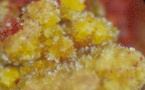


Hilarion Mine, Kamariza Mines, Agios Konstantinos, Lavrion Mining District, Lavreotiki, East Attica, Attica, Greece