| Locality type: | Quarry |
| Classification |
|---|
|
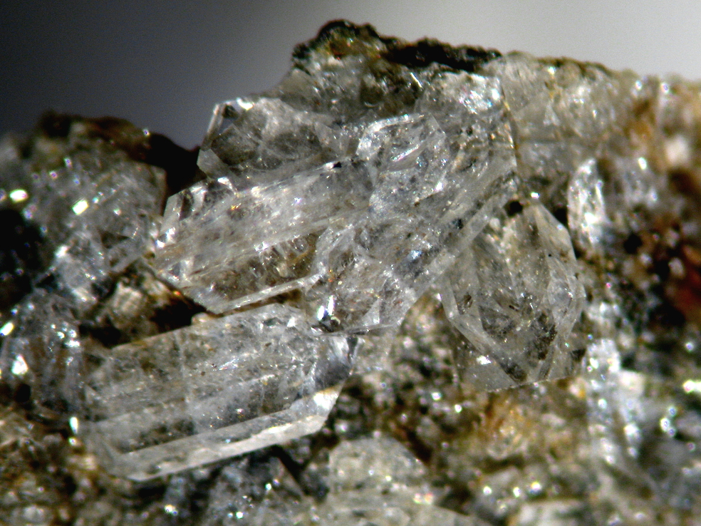
| Species: | Harmotome |
| Formula: | Ba2(Si12Al4)O32 · 12H2O |
| Habit: | squat to prismatic cruciform (Perrier and pseudohexagonal morvenite) twins up to 5mm but usually less than 2mm. |
| Colour: | colourless to white |
| Confirmation |
|---|
|
| Validity: | Confirmed |
| Confirmation Methods: | XRD
SEM-WDS |
| Associated Minerals Based on Photo Data: |
|---|
|
| Edingtonite | ⓘ1 photo of Harmotome associated with Edingtonite at this locality. |
| Data |
|---|
|
| Mineral Data: | Click here to view Harmotome data |
| Locality Data: | Click here to view Guisachan Quarry, Tomich, North, West and Central Sutherland, Highland, Scotland, UK |
| Photo Gallery | View Gallery (2 photos) |
| Data Identifiers |
|---|
|
| Mindat Occurrence Record ID: | 619476 |
| Long-form Identifier: | 1:3:619476:5 |
| GUID (UUID V4): | e4d9ec80-ec72-4eac-bcc2-391f7393d85d |
| Nearest other occurrences of Harmotome |
|---|
|
|
| 13.1km (8.1 miles) | ⓘLoch na Meine Mine, Strathglass, Aird and Loch Ness, Highland, Scotland, UK |
| 13.6km (8.4 miles) | ⓘAllt Tighe Cumhaig, Struy, Strathglass, Aird and Loch Ness, Highland, Scotland, UK |
| 71.5km (44.4 miles) | ⓘClashgorm Mine, Strontian, Fort William and Ardnamurchan, Highland, Scotland, UK |
| 76.8km (47.7 miles) | ⓘBellsgrove Mine (Bellsgrove Opencut), Strontian, Fort William and Ardnamurchan, Highland, Scotland, UK |
| 76.9km (47.8 miles) | ⓘBellsgrove Quarry (Strontian Barytes Mine; Middleshop mine), Strontian, Fort William and Ardnamurchan, Highland, Scotland, UK |
| 77.7km (48.3 miles) | ⓘWhitesmith Mine, Strontian, Fort William and Ardnamurchan, Highland, Scotland, UK |
| 79.0km (49.1 miles) | ⓘCorrantee Mine, Strontian, Fort William and Ardnamurchan, Highland, Scotland, UK |
| 81.5km (50.6 miles) | ⓘStrontian, Fort William and Ardnamurchan, Highland, Scotland, UK |
| 96.1km (59.7 miles) | ⓘTyndrum lead mine, Tyndrum, Stirling, Scotland, UK |
| References |
|---|
|
|
| Reference Search (possible matching items) |
|---|
 | | Journal (volume) | | mineralogy EDITOR: Norman Moles, School of Environment and Technology, University of Brighton, Cockcroft Building...Austell, U.K. A.D. Hart NHM, London, UK RA. Howie, Matlock, UK RJ. King, Tewkesbury, U.K. I.R Plimer... Parkville, Australia M.T. Price, OUMNH, Oxford, UK RE. Starkey, Bromsgrove, U. K. RF. Symes, Sidmouth...Australia Aims and Scope: The Journal publishes refereed articles by both amateur and professional mineralogists...Isles. Contributions are welcome from both members and non-members of the Russell Society. Notes for contributors |  | | Book | | Islands Juan Carlos Carracedo & Simon Day 5. The north of Ireland Paul Lyle 6. Leinster Chris Stillman...Nortlrn·est Highlands of Scotland Con Gillen 9. The Inner Hebrides of Scotland Con Gillen 11. The Gulf...Alexander Geology and landscapes of Scotland Con Gillen La catastrophe: A1ow11Pelee and the desrruction...Claudio Vita-Finzi Principles of emergency planning and ma11agemer:1DaYid Alexander Vesurius: a biography...Scarth & Jean-Claude Tanguy Minerals of Britain and Ireland A. G. Tindle The Open University T: 'XI |
|


Guisachan Quarry, Tomich, North, West and Central Sutherland, Highland, Scotland, UK