 | | Journal (article/letter/editorial) | | Michigan Mineralogy: A LOCALITY INDEX TOM MORRIS, JR. 4553 Shenandoah Allen Park, Michigan 48101 Tom...occurrences. These localities have been listed by county; and, strictly for convenience, the list has been...compiling this information was The Mineralogy of Michigan (Heinrich, 1976), which should be consulted by...locality labeling of Michigan specimens. It should be pointed out that the list of Michigan mineral localities...None theless, with the aid of a good state or county map, plus local inquiries, the list could be helpful |  | | Report (issue) | | .......................................... 18 Calcite .................................................The most common minerals in these sediments are calcite, clay minerals, dolomite, glauconite, goethite...of geodes from Big Walnut Creek, Putnam County; and many quarry operators for granting us permission to...Indians knew of and used Wyandotte Cave in Crawford County (4).2 Ball (1941, p. 39) summarized the various...The Indians found that Wyandotte Cave, Crawford County, Ind., contained two desirable products, a jaspery |  | | Report (edition) | | ls, Inc., Auglaize quarry (formerly Stoneco, Inc.}, near Junction, Pau lding County, Ohio. Specimen is...Washington (1956), a M.S. from the Un iversity of Co lorado (1960), and a Ph.D. from McGil l University...Auglaize quarry near Junction, Paulding the Huron River, resulting in the discovery of two County, Ohio...knowledge. Included in its pages are a con1prehensive co llection of literature and a cogent summary of Oh...geology. The highlight is a grand, we ll-i llustrated co llection of all 111ineral species known lo occur |  | | Journal (article/letter/editorial) | | offers an array of other minerals, including superb calcite, strontianite, barite, dolomite, and sphalerite...famous Green (Strontian) Island site in Ottawa County (Douglass, 1820, 1821). Although Ohio's minerals...warning, and collectors are advised to contact quarry operators well in advance of a trip. The Re port...An attempt has been made to trace the history of quarry activities because several important mineral discoveries...extension into Allen County in northeastern Indiana and Monroe County in southeastern Michigan, the district |  | | Report (issue) | | kiln was I mile northwest of Stinesville in Monroe County. The Lime Industry of Indiana By CURTIS H...lime kiln near Milltown , Crawford County, used by J. B. Speed & Co. from 1887 to about 1915 / 10 6 ... Modern rotary kilns at the Marblehead Lime Co. plant at Buffington near Gary / 11 7 Generalized columnar...Lithofacies (Wabash Formation) exposed in the Erie Stone Co. quarry at Huntington / 16 9 Abandoned vertical...used by the France Stone Co. , Logansport , from about 1900 to 1943 / 18 10 Abandoned quarry near Rabbitville |  | | Journal (article/letter/editorial) | | Trenton Limestone and the Cambrian Knox Dolospreadin quarry exposures of carbonaterocksin mite (Stieglitz,1975;...al., 1988). It is hopedthat the discussion and Michigan(Heyl, 1968; Carlson,1983, 1990). of the surface...asisotopicmeasurements of sulfurand the west; Maybee, Michigan, on the north; and lead indicate.Liquid and solidhydrocarbons...M - MISSISSIPPIAN MONROE ST. JOSEPH I BRANCHI HILLSDALE ' • LAKE ERIE MICHIGAN ...FRACTURES EARLY DOLOMITE PYRITE-MARCASlTE CELESTITE CALCITE (EARLY VEINS) FLUORITE (BR) FLUORITE (YEL,WH) |  | | Journal (article/letter/editorial) | | limestone has been quarried near Rockwood, Franklin Co., Ala. ARIZONA—Small purple amethyst xls with red...Red Cloud mine (about 30 miles N . of Yuma), Yuma Co., Ariz., have been received from Earl U. Mayer, 1733...are still to be found at the Saddle Mt, Maricopa Co., Ariz., location. The best of these compare favorably...the mountain, for 3 miles. The gravel road is a county road, usually fair except after heavy rains. At...sample came from the Oak Hill mines of Santa Clara Co., Calif. The following is taken from his letter which |  | | Journal (article/letter/editorial) | | The most abundant minerals in these rocks are calcite, clay minerals, dolomite, glauconite, goethite...inclusions with pyrrhotite and other iron sulfides in calcite, barite, dolomite, and quartz in geodes. Other...left): Calcite, twinned on {0221}, 4 cm across; Meshberger Stone, Inc. quarry, Bartholomew County. Richard...center): Calcite with marcasite inclusions; largest crystal 3.5 cm across; Berry Materials quarry, Jenn...right): Pyrite, 1.5 cm high; Rensselaer Stone C o . quarry, Jasper County. Vernon Swanson speci men; Richard |  | | Book (volume) | | Loudsville in White Co. and the other on the Bear Cr. near Dahlonega in Lumpkin Co. Not only was placer...4½ carats picked up near Morrow Station in Clayton Co. in 1887. Since then, many fine diamonds have been...northeastward through Dahlonega Co. and Rabum Co., and the McDuffie County Belt extending through portions...Sphalerite. BALDWIN COUNTY MILLEDGEVILLE, at state farmjasper. BANKS COUNTY COMMERCE, along Hwy. 59...Jackson-Banks Co. lineBeryl. MAYSVILLE, area gravels along adjoining Co. linerock crystal. BARROW COUNTY WINDER |  | | Report (issue) | | BEDROCK GEOLOGY AND MINERAL RESOURCES OF PUTNAM COUNTY, INDIANA Special Report 26 -- Special State... Bedrock Geology and Mineral Resources of Putnam County Indiana By JOHN R. HILL, MICHAEL C. MOORE, and...Page Map of Putnam County showing physiographic units .2 Map of Putnam County showing general distribution... .2 Map of Putnam County showing drainage network . . . . Map of Putnam County showing bedrock topography...topography .3 .4 7 Map of Putnam County showing unconsolidated deposits Map of Indiana showing the eastern |  | | Journal (article/letter/editorial) | | Rosemeyer histori cal photo. May/June: Barite on calcite, Stoneham, Colorado; Brian Lees specimen, John...Westmoreland, New Hampshire; Resur rection Mining Co. specimen, Ronald E . Bentley photo. September/October:...specimen and photo. November/December: Calcite, France Stone Co., Custar, Ohio; Neal Pfaff specimen, Terry...Minerals in Keweenawan Basalt, South Range Quarry, Douglas County, Wisconsin, W. S. Cordua, 412-415 Anatase...Minerals of Moroc co, 67 Cook, W. and A., see Through the 'Scope Copper, Michigan, 242 Cordua, W. S. |  | | Journal (article/letter/editorial) | | at mouth of Silver Creek near Edinburg, Portage County. Figure 1 (left). Rosanna Carlson sitting in dolostone...septarium, Copperas Mountain near Spargursville, Ross County. Ernest Carlson photo. Figure 3. Map showing mineral...predominantly of ferroan dolomite, with lesser amounts of calcite, quartz, illite, and pyrite; siderite is absent...concretions are septaria. Dolomite, ferroan dolomite, calcite, barite, and quartz are the main vein minerals;...Km-h Ming strata dolojtooc fctroan dolomite. calcite. quartz, pyrite fcrroan dolomite, calcitc. barite |  | | Journal (article/letter/editorial) | | dolomite in the vicinity of CIay Center, Ottawa County, Ohio, (lat.41o 34'N.; long.83o 22'W.) are found...fluorescent fluorite. Other associated minerals include calcite, aragonite, dolomite, strontianite, pyrite, marcasite...from similar occurrencesto the north in Monroe County, Michigan, are associatedwith free sulfur and hydrogen...blade from the southeastwall of the Basic,Inc., quarry at Clay Center, about 15 m below top of bedrock...g . 8 3 ' 17'W.; USNM1 94965), at the France Stone Co. quarry, Waterville, Ohio (lat. 41o30'N.;long. |  | | Book (volume) | | 600 to 800 feet thick in the north. ALEXANDER COUNTY FAYVILLE, area stream gravels⎯agate, jasper, rare...⎯agate, jasper; d RR siding of Clay⎯agate. CALHOUN COUNTY AREA, shores of the Mississippi R., in the Warsaw...crystals). CRAWFORD COUNTY PALESTINE, area deposits⎯Siderite. EDWARDS COUNTY AREA, T. 1 S, R. 10 E...E, regional deposits⎯Siderite. FULTON COUNTY FARMINGTON, W 6 mi. on Rte. 116 to the Rapatee No. 5 strip...mine⎯pyritized gastropods (Pennsylvanian age). GRUNDY COUNTY AREA: c Regional rd. and RR cuts and banks of Mason |  | | Book (volume) | | 600 to 800 feet thick in the north. ALEXANDER COUNTY FAYVILLE, area stream gravels⎯agate, jasper, rare...⎯agate, jasper; d RR siding of Clay⎯agate. CALHOUN COUNTY AREA, shores of the Mississippi R., in the Warsaw...crystals). CRAWFORD COUNTY PALESTINE, area deposits⎯Siderite. EDWARDS COUNTY AREA, T. 1 S, R. 10 E...E, regional deposits⎯Siderite. FULTON COUNTY FARMINGTON, W 6 mi. on Rte. 116 to the Rapatee No. 5 strip...mine⎯pyritized gastropods (Pennsylvanian age). GRUNDY COUNTY AREA: c Regional rd. and RR cuts and banks of Mason |  | | Report (issue) | | site of the former town of Alum Cave, Sullivan County, in the NW¼NE¼ sec. 25, T. 9 N., R. 8 W. Description...outcrop in northern Vigo County and Vermillion County. South of Sullivan County , the limestone is thin... 8 N ., R. 8 W., near Antioch Church, Sullivan County. This unit lies 2 feet below the Bucktown Coal...south of Knox County but is present northward from its type area to Vermillion County. Antrim Shale,...the St. Clair, that was well exposed in Antrim County, Mich., and Lane ( 1902, map) later actually adopted |  | | Report (issue) | | percent) of samples from the Russellville Stone Co. quarry, Putnam County, Ind -----------------32 7. Chemical...samples from the Ohio and Indiana Stone Co. quarry, Putnam County, Ind------------------------------...samples from the Manhattan Crushed Stone Co. quarry, Putnam County, Ind ----------------- 34 9. Chemical...percent) of samples from the State Farm quarry, Putnam County, Ind ----------------------------- 35 10...percent) of samples from the Dunn Limestone Co. quarry, Owen County, Ind ------------- 36 11. Chemical and |  | | Report (issue) | | Crushed Stone Resources of the Blue River Group (Mississippian) of Indiana BULLETIN 52 SCIENTIFIC AND...Head PAT GERTH, Sales and Records Clerk Crushed Stone Resources of the Blue River Group (Mississippian)...mine dust 45 Dimension limestone 46 Filter stone 51 Flux stone 52 Glass 52 Lime 53 Mineral wool 58 Neutralization...Literature cited 61 Appendix 1. Producers of crushed stone from the Blue River Group in Indiana 71 Appendix...with Ste. Genevieve limestone from the Mountain Quarry 49 Illustrations Figure 7 Tombstone carved from |  | | Journal (article/letter/editorial) | | is considered to be a replaoement mineral after calcite or aragonite and the abundance of Sr in “secondary”...GARRELS, THOMPSON and SIEVER (1960) show that calcite and magnesite mixtures are unstable with respect...in addition to dolomite, primary and secondary calcite, authigenic and detrital clay minerals, minerals...secondary origin, i.e. replaoing pre-existing calcite, and (2) the so-called “primary” dolostones which...the “primary” division contained no detectable calcite. Secondary dolostones exhibit much coarser grain |  | | Report (issue) | | Central Clark County region ...................................... . Southern Harrison County region ......of samples from Bloomington Crushed Stone Co. quarry, Monroe County, Ind. . . . . . . . . . . . . . . ...samples from abandoned quarry of the Bloomington Crushed Stone Co., Monroe County, Ind. . . . . . . . ...percent) of samples from the Stinesville quarry section, Monroe County, Ind.... Chemical and spectrographic...percent) of samples from abandoned quarry of the France Stone Co., Owen County, Ind. . . . . . . . . . . . |  | | Book | | commercial ores and secondary minerals by state, county, township, and geologic range. For easy identification...cities, and many of today’s prosperous western county seats began as mining-boom camps. trating sand...you such as those listed alphabetically by county, township, and range in Part II of this book. Where...maps. Yet, were you to risk a ruptured oil pan, a stone-bruised tire, or becoming stranded in deep sand...however small or short-lived, served as a stepping stone bridging a hostile frontier, helping to erase America’s |  | | Book | | nWM@OLA-CARNEGIE PUBLIY Nature Collection a (ony BRARY CO FOSSILS IN AMERICA a Be sansa? ee eee eae...cessor. Not infrequently, when looking for gem stone or mineral float in the sedimentary detritus of...maps used by mining geologists, prospectors, gem-stone hunters, and rock collectors are based on outcrops...fossil-hunting localities, organized by state, county, township, section, or other landmark, together with...7 THE ERA OF THE FLOODISTS In a limestone quarry near the village of Oeningen in Upper Baden, stonemasons |  | | Report (issue) | | charts depart from the COSUNA plan. Specifically, the CO SUN A scheme, if generally accepted, will bring about...rock above the Springfield Coal Member in Sullivan County, Ind. Logan's term was modified to "Alum Cave Limestone"...site of the former town of Alum Cave, Sullivan County, Ind., in the NW¼NE¼ sec. 25, T. 9 N., R. 8 W....Sullivan County and Vigo County and cannot be identified in outcrop in northern Vigo County and Vermillion...Vermillion County. South of Sullivan County the limestone is thin and nodular. It can be traced as gray to |  | | Report (issue) | | Crushed Stone Resources of the Devonian and Silurian Carbonate Rocks of Indiana BULLETIN 37 I DEPARTMENT...DONNA C. SCHULTZ, Sales and Records Clerk Crushed Stone Resources of the Devonian and Silurian Carbonate...38 Appendix 1. Directory of producers of crushed stone from Devonian and Silurian strata / 48 Appendix...Clark County / 11 5 Primary dip in the Salamonie Dolomite, sec. 33, T. 23 N., R. 13 E., Adams County / 19...Limestone / 21 7 Crushed stone being loaded in barges at Utica, Clark County, for out-of-state markets |  | | Report (issue) | | ENVIRONMENTAL GEOLOGIC FACTORS AS AIDS TO PLANNING IN CASS COUNTY, INDIANA Special Report 22 State of Indiana Department...Environmental Geologic Factors as Aids to Planning in Cass County, Indiana By JOHN R. HILL ENVIRONMENTAL STUDY 16...formations on outcrop and beneath glacial drift in Cass County . . . . . . . . . . . . . . . . . . . . . . . ...Generalized bedrock stratigraphic column for Cass County . . . . . . . . . .3 3 Well log of bedrock units...topography of Cass County .7 7 Map showing distribution of unconsolidated deposits in Cass County .8 8 Map |
|


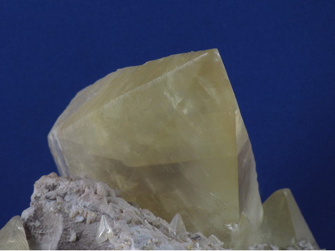
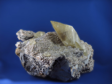


France Stone Co. Quarry, Monroe Charter Township, Monroe County, Michigan, USA