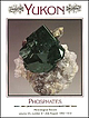
 | | Journal (issue) | | ‘D ’ Ottawa, Ontario, Canada K IP 6P4 H. Gary Ansell Geological Survey of Canada 601 Booth Street Ottawa...Ottawa, Ontario, Canada K1A 0E8 (Geological Survey of Canada contribution number 38290) B. Darko Sturman...Ontario Museum 100 Queen’s Park Toronto, Ontario, Canada M5S 2C6 $ 1992 T h e M in e r a l o g ic a l R...and pale purple fluorapatite, from the Rapid Creek area, Yukon Territory. Keith Williams specimen; photo...45 46 Figure 1. The Big Fish River, northern Yukon Territory, as viewed from collecting area “ C.” |  | | Book | | appear after page numbers. () Reported from this locality; no further information b Book review c Crystal...Historical information m A map of the locality or a map on which the locality appears n Brief descriptive note... etc.) s Specimen locality attribution only; no information about the locality itself In the case...special issues, the letter precedes the page number. Yukon Phosphates (vol. 23, no. 4) Therefore, the Tsumeb...Tsumeb; 23/#2, Michigan Copper Country; 23/#4, Yukon Phosphates; 24/#2, Greenland; and 25/#6, The History |  | | Report (issue) | | OCCURRENCES IN CANADA (Preliminary Account) Robert Mulligan 1960 GEOLOGICAL SURVEY OF CANADA CANADA PAPER...PAPER 60-2.1 BERYLLIUM OCCURRENCES IN CANADA (Preliminary Account) By Robert Mulligan DEPARTMENT MINES...MINES AND OF TECHNICAL SURVEYS CANADA CONTENTS Page Introduction . . . . . . . . . . . . . . . . ................................. Wolf Lake area, Yukon . . . . . . . . . . . . . . . . . . . . . . . .... . . . . . . . . . . . . . . . . . . McConnell Creek area, B. C. . . . . . . . . . . . . . . . . . . |  | | Report (issue) | | Resource Data File BD001 Site name(s): Banner Creek Site type: Mines ARDFno.: BD001 Quadrangle: BDB-5...accuracy: Banner Creek drains southward into the Tanana River. The approximate center of mining activity on...on Banner Creek is in SW1/4SW1/4 section 10, T. 7 S., R. 7 E., of the Fairbanks Meridian, approximately...town of Richardson on the Richardson Highway. The creek is approximately 6 miles long and has several tributaries...These include Buckeye Creek (BD005), Democrat Pup Creek (BD013), and Susie Creek (not identified on existing |  | | Report (issue) | | Alaska and the Yukon Proceedings of a cooperative workshop between earth scientists from Canada and the United...U.S. Geological Survey, New Federal Building- Box 12 101 Twelfth Ave., Fairbanks, AK 99701 Maps Maps...History of the Interior Basins of Alaska and the Yukon L. DAVID CARTER, THOMAS D. HAMILTON, and JOHN P...cooperative workshop between earth scientists from Canada and the United States of America U.S. GEOLOGICAL...history of the interior basins of Alaska and the Yukon I L. David Carter, Thomas D. Hamilton, and John |  | | Report (issue) | | than 21 horizontal kilometers) and demonstrates rapid Neogene uplift and denudation (see article by O'Sullivan...mine-drainage waters associated with low-sulfide, gold-quartz veins in Alaska Richard J. Goldfarb, Cliff D. Taylor...Mine-Drainage Waters Associated with Low-Sulfide, Gold-Quartz Veins in Alaska By Richard J. Goldfarb, Clifford...lowsulfide, gold-quartz veins in the Fairbanks, Willow Creek, and Juneau gold belt mining districts. All...valley adjacent to the Hi-Yu mine in the Fairbanks district had a pH of 5.2. Near Juneau, processing of ore |  | | Report (volume) | | 27-36. Minneapolis, Minn. American Institute of Mining Engineers: Transactions, vols. 30-35; Bimonthly...Bulletin, vol. 2, no. 8-vol. 4, no. 13. Berkeley, Cal. Canada: Geological Survey: Annual Reports, new ser., vols...Catalogue of the Marine Invertebrata of Eastern Canada. Canada, Royal Society: Proceedings and Transactions...Ottawa, Canada. , . . .Canadian Institute: Transactions, vol. 7 and vol. 8, pt. 1. Toronto, Canada. Canadian...Canadian Mining Institute: Journal, vols. 4-7. Ottawa, Canada. Canadian Mining Review: vols. 20-24. Ottawa |  | | Report (issue) | | gold- and silver-bearing sulfide ores, Ohio mining district, Marysvale, Utah, by A. S. Radtke, C. M. Taylor...214 217 221 228 Analytical methods A simple and rapid indirect determination of fluorine in minerals and...quantity of dissolved solids transported by Sharon Creek near Palo Alto, Calif., after suburban development...Mountain: H. F. Albee, unpublished map. Camp Davis, Pine Creek, Bailey Lake, and Pickle Passreconn. geology...Bear River Formation and Gannett Group • PINE CREEK Jurassic and Triassic rocks Paleozoic rocks Fault |  | | Book (volume) | | James H. Dover . 141 . 153 6. Geology of the Yukon-Tanana area of east-central Alaska Helen L. Foster... Roland von Huene, and Andrew J. Stevenson 367 12. Geology of the southern Alaska margin . George Plafker...Lithotectonic terrane map of Alaska and adjacent parts of Canada, 1 sheet, scale 1:2,500,000 (Norman J. Silberling...Robinson, Thomas E. Smith, and Warren Yeend) Plate 12. Neotectonic map of Alaska, 1 sheet, scale: 1:2,500...the volumes published by the Geological Survey of Canada vu . Foreword To those of you who are using |  | | Report (issue) | | Computer-generated latitude and longitude templates for rapid determination of geographic positions in Alaska...Moore ••••••...••••..•••••••••••••••••••••• Kivivik Creek: A possible zinc-lead-silver occurrence in the Kuna...••••••••••••• iii 1 1 1 1 5 7 9 10 10 11 12 12 16 17 19 20 21 24 24 27 30 32 34 34 37 Page...New ages of radiolarian chert from the Rampart district, east-central Alaska, by David L. Jones, Norman...tectonic affinities of some amphibolites from the Yukon-Tanana Upland, east-central Alaska, by Cynthia Du |  | | Report (issue) | | ............. 10 12 History of Gem Mining ..... .......................... . 12 Important Gem Stones.................................................. 12 Diamond ......................................................................................... 12 Ruby.................................................................................... 16 17 Quartz ................................................... Rose Quartz ....................................................... 18 18 Smoky Quartz ........ | | | Report (issue) | | THULITE AND PYRITE MONAZITE EMERALD CUPRITE SMOKY QUARTZ ZIRCON TORBERNITE ~/ UBRAR'l USE ONLV ,~O...amethyst, almandite garnet, citrine, and smoky quartz. It is hoped that this publication will find a...NORTH CAROLINA 12 History of Gem Mining 12 Important Gem Stones 12 Diamond 12 Corundum 13 Ruby...Rutile 17 Quartz 17 Rock Crystal 17 Amethyst •• 18 Rose Quartz 18 Smoky Quartz 18 Rutilated...Rutilated Quartz 18 Chalcedony 19 Agate 19 References 20 SAFETY TIPS FOR ROCK AND MINERAL COLLECTORS |  | | Report (issue) | | Brooks Range, and the southern quarter is in the Yukon Flats. Outcrops of bedrock are poor or lacking,...Plateau, along the East Fork Chandalar and Vanticlese Creek, most of the upland areas in the Porcupine Plateau... The southern quarter of the quadrangle in the Yukon Flats is covered with unconsolidated glacial and...the end of the summer they canoed back to Fort Yukon on the East Fork. These trips along the rivers in...1949 mapped the Yukon Flats from Circle to Beaver by boat and foot traverses along the Yukon and its tributaries |  | | Report (volume) | | Bulletin, vol. 41. New York. American Institute of Mining Engineers: Bulletin, nos. 25-36; Transactions,...series, vols. 27, 28. New Haven, Conn. American Mining Congress: Papers and Addresses, llth Annual Session;...History, 8th ser., vols. 3, 4. London. Appalachia, vol. 12, no. 1. Boston, Mass. Arkansas Geological Survey:... vol. 2, no. 2. Oakland, Cal. California State Mining Bureau: Bulletin, nos. 54-56. San Francisco, Cal...Geology: Bulletin, vol. 5, nos. 18-23. Berkeley, Cal. Canada, Geological Survey: Summary Report for 1908; and |  | | Journal (volume) | | Chief Geologist Logan, District Mining Engineer W. Burling Tucker, District Mining Engineer Reid J. Sampson...Assistant District Mining Engineer Chas. V. Averill, District Mining Engineer J. C. O'Brien, District Mining...Statistician and Curator James M. Little, Junior Mining Engineer (Librarian) Elisabeth L. Egenhoff, Editor...and, since July 1922, District Mining Engineer for the San Francisco District, died suddenly at his Alameda...California Division of Mines (known as the State Mining Bureau at that time) his writings for its official |  | | Report (issue) | | Terminus of Hubbard Glacier from Osier Island, january 12, 1986. Photograph by L.R. Mayo. Geologic Studies...Age Determination for the Limestone of the Lost Creek Unit, Livengood C-4 Quadrangle, East-Central Alaska...Comparative Petrologic Study of Sandstone from the Wilber Creek, Cascaden Ridge, and Wickersham Units in the Livengood...Mineralization by Metamorphic Fluids in the Chandalar District, Southern Brooks Range--Fluid Inclusion and Oxygen-Isotopic...lcefield Ranges of Yukon Territory, Canada, and in the St. Elias Mountains of Canada and Alaska. It flows |  | | Report (issue) | | Rutile and Rutilated Quartz. ... 9 Rutile, Xenotims and Monagite. ........ 9 Smoky Quartz, Goethite and Graphite...Garnet 24 Staurolite CLEVELAND COUNTY. 24. . . Quartz Corundum 24 . ♦ . . 24 26 . Beryl # 26...COUNTY Petrified Wood FRANKLIN COUNTY Amethyst Quartz GASTON COUNTY Cassiterite and Spodumene Kyanite... . ■. Sagenite Beryl and Tourmaline . Rose Quartz . . . . •.. ■ Rutile . Ultramafic Minerals...Pyrophyllite \ \ \ \ Zircon and Corundum Calcite and Quartz Jasper. 37 Copper -iii- /Q l& 4.9 4,9 51 |  | | Report (issue) | | of finegrained Tertiary sandstone contained 11 and 12 ppm uranium and up to 30 percent magnetite. (Description...File PE002 Site name(s): Unnamed (near Gunnuk Creek) Site type: Prospect ARDFno.: PE002 Latitude: 56...description and accuracy: Claims on upper Gunnuk Creek, northwestern Kupreanof Island, about three miles...miles northeast of the town of Kake. Locality 9 of Grybeck, Berg, and Karl (1984). Location known only generally...Mines, 1980; and State of Alaska unpublished Kardex mining claims file). Alteration: Age of mineralization: |  | | Report (issue) | | detrital material from a small drainage at this locality. A heavy mineral concentrate obtained from the...Resource Data File SO002 Site name(s): Carson Creek Site type: Prospect ARDFno.: SO002 Latitude: 64...Darby Peninsula, about 3 miles northeast of Carson Creek (Smith and Eakin, 1911). It is apparently near a...miles northwest of the mouth of McKinley Creek. It is locality 135 of Cobb (1972, MF445; 1978, OF 78-181);...Resource Data File SO004 Site name(s): Koyana Creek Site type: Mine ARDFno.: SO004 Quadrangle: SO C-4 |  | | Journal (article/letter/editorial) | | BOUNDARY THRUST ZONE, GRENVILLE PROVINCE, ONTARIO, CANADA WILLIAM H. PECK§ AND JOHN W. VALLEY Department...cordierite + gedrite assemblages. Diffusion modeling of quartz–garnet fractionations suggests intermineral exchange...Un modèle de diffusion du fractionnement entre quartz et grenat nous incite à proposer un échange interminéral...william@geology.wisc.edu 511 38#2-avril00-2137-13 511 12/07/00, 8:50 512 THE CANADIAN MINERALOGIST the...the same bulk composition as lower-grade quartz – chlorite lithologies, which are interpreted to be hydrothermally |  | | Report (issue) | | Field equipment for winter ...... : . .... ·. . Camp gear ..................... ~ . . . . Dog sleds:.... . . Field equipment for summer............... Camp gear. . . . . . . . . . . . . . . . . . . . . ..... . . . . . . . . . . . . . . . . . . 9 11 11 12 12 13 19 H) 19 19 19 19 21 21 21. 21 24 25 25 25...- .. -- - - - -- - -- - - - - - -- - -.. Alaska-Canada Boundary Survey-, 1912 Canadian Arctic Expedition...Canning River .............-..... . 138 103 140 Marsh Creek ................... . 105. Extent and character |  | | Report (volume) | | politico-geographic divisions containing the type locality of the unit provided a valuable key to the literature...(but not the definitions) of geologic units of Canada, Mexico, the West Indies, LEXICON OF GEOLOGIC...Underlies Church limestone member; overlies Bachelor Creek limestone member. M. R. Mudge, C. P. Walters, and...Pittsylvania and Halifax Counties, overlies Hyco quartz porphyry. Varies from nearly pure greenstone to...Precambrian. Well exposed at many places along Aaron's Creek, Person and Granville Counties, N.C. Abbott Formation | | | Report (issue) | | Alaska Resource Data File Site name(s): Slope Creek Site type: Mine ARDF no.: NB001 Latitude: 62.7879...This placer mine is on Slope Creek, a west tributary to Porcupine Creek. It is at an elevation of about...600 feet, about 1.1 miles upstream from Porcupine Creek. It is close to the west boundary of the Nabesna...SW1/4 of section 30, T. 12 N., R. 8 E. of the Copper River Meridian. This is locality 58 of Richter and others...others (1975). Slope Creek is not named on the USGS Nabesna D-6 quadrangle (revised 1969) but it is clearly |  | | Report (issue) | | River, near Old Rampart; locality recorded here is from Cobb (1972) and locality 15 of Barker and Clautice...Last report date: 9/12/96 Page 2 Alaska Resource Data File Pages Site: Rapid River tributary Type:...Orphan near fork in unnamed NW flowing tributary of Rapid River; located to within 1500 ft (457 m). Commodities:...Last report date: 9/12/96 Alaska Resource Data File Page 4 Site: Sunaghun Creek Tributary Type: Occurrence...up northwest tributary in headwaters of Sunaghun Creek; located to within 1 mi (1.6 km). Commodities: Main: |  | | Report (volume) | | _____________ ______________ ______ 1 1 3 4 6 7 11 12 16 28 31 364 ILLUSTRATION PLATE 1. Map showing...location and means of access to all the metallic mining districts in the State, as well as a large number...and used agate, chalcedony, and other forms of quartz for weapons and tools; they used clay for pottery...for decorations, and they cherished crystals of quartz or other minerals as amulets. After the Indians...documented summary of the beginning of Colorado mining history. Part of his summary is given here in the |
|


