| Locality type: | Mountain |
| Classification |
|---|
|
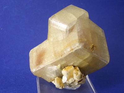
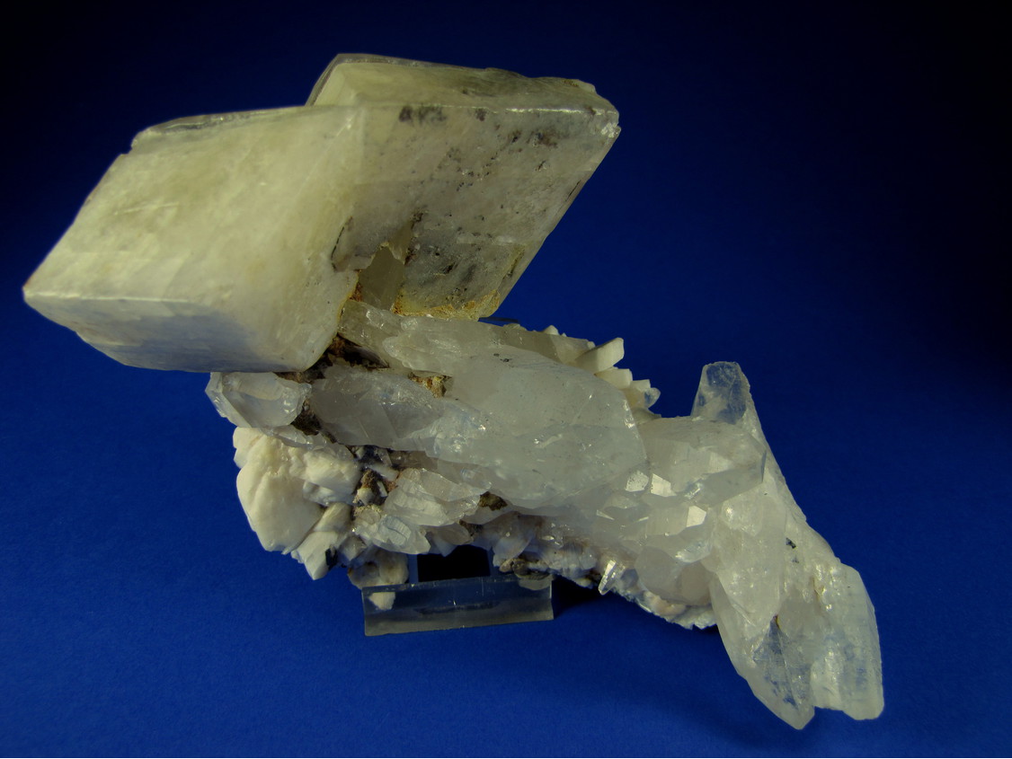
| Species: | Calcite |
| Formula: | CaCO3 |
| Confirmation |
|---|
|
| Validity: | Believed Valid |
| Associated Minerals Based on Photo Data: |
|---|
|
| Pericline | ⓘ3 photos of Calcite associated with Pericline at this locality. |
| Rock Crystal | ⓘ2 photos of Calcite associated with Rock Crystal at this locality. |
| Rutile | ⓘ2 photos of Calcite associated with Rutile at this locality. |
| Limonite | ⓘ2 photos of Calcite associated with Limonite at this locality. |
| Albite | ⓘ2 photos of Calcite associated with Albite at this locality. |
| Quartz | ⓘ1 photo of Calcite associated with Quartz at this locality. |
| Data |
|---|
|
| Mineral Data: | Click here to view Calcite data |
| Locality Data: | Click here to view Grieswies-Schwarzkogel, Grieswies - Krumlkeeskopf area, Rauris, Zell am See District, Salzburg, Austria |
| Photo Gallery | View Gallery (3 photos) |
| Data Identifiers |
|---|
|
| Mindat Occurrence Record ID: | 689037 |
| Long-form Identifier: | 1:3:689037:7 |
| GUID (UUID V4): | d60f1c2e-93bb-4734-95da-d1c9422051c3 |
| Nearest other occurrences of Calcite |
|---|
|
|
| 0.7km (0.4 miles) | ⓘHocharn, Grieswies - Krumlkeeskopf area, Rauris, Zell am See District, Salzburg, Austria |
| 1.0km (0.6 miles) | ⓘWest slope, Hocharn, Große Fleiß valley, Heiligenblut am Großglockner, Spittal an der Drau District, Carinthia, Austria |
| 1.1km (0.7 miles) | ⓘSouthwest face, Hocharn, Große Fleiß valley, Heiligenblut am Großglockner, Spittal an der Drau District, Carinthia, Austria |
| 1.2km (0.8 miles) | ⓘErfurt way, Grieswies-Schafkar, Grieswies - Krumlkeeskopf area, Rauris, Zell am See District, Salzburg, Austria |
| 1.3km (0.8 miles) | ⓘKruml glacier, Rauris, Zell am See District, Salzburg, Austria |
| 1.4km (0.9 miles) | ⓘJausenscharten, Hocharn, Große Fleiß valley, Heiligenblut am Großglockner, Spittal an der Drau District, Carinthia, Austria |
| 1.5km (0.9 miles) | ⓘRitterkar, Ritterkopf massif, Rauris, Zell am See District, Salzburg, Austria |
| 1.5km (0.9 miles) | ⓘGoldlacklscharte, Ritterkopf massif, Rauris, Zell am See District, Salzburg, Austria |
| 1.7km (1.1 miles) | ⓘGold mine (Goldzeche), Zirmsee area, Heiligenblut am Großglockner, Spittal an der Drau District, Carinthia, Austria |
| 1.9km (1.2 miles) | ⓘBiwakschachtel (Biwakscharte), Hocharn, Große Fleiß valley, Heiligenblut am Großglockner, Spittal an der Drau District, Carinthia, Austria |
| References |
|---|
|
|
| Reference Search (possible matching items) |
|---|
 | | Journal (article/letter/editorial) | | Geowissenschaften (Mineralogie) der Universit~t Salzburg, Austria, and the Canada Centre for Mineral and Energy...Waschgang Gold-Copper Deposit, Upper Carinthia, Austria 1 W. H. Paar and T. T. Chen With 13 Figures Received...between 2000 and 3000 m. Mining activities in this area were reported as early as R o m a n times. Since...WaschgangGold-Copper Deposit ~+~ . . . . ~+ SALZBURG ~"~ AREA OF INVESTIGATION ~ .... .., VJena " ...Christi Leiden) E of M611tal, Upper Carinthia, Austria has continued until the early decades of the 20th |  | | Journal (issue) | | sei. Daraufhin haben einige unserer Kollegen dies am 13. 6. 1981 auch tatsächlich versucht. Das Ergebnis:...der Santana-Formation, die vor allem in Bachrissen am Nordhang des Araripe-Plateaus gut erschlossen sind...Foto: Oehme Der Ammererhof ( 1628 m) gegen Grieswies-Mahder und Riuerkopf (3006 m). Der Ammererhof...Bodenhaus (/236111) Ausgangspunkt fiir die Mineralsuche am Rillerkopf Foto: Gehrnza1111 Brasilien ist für seinen...abgebildetes Mineral ist der Elat-Stein vom Roten Meer Am Roten Meer wurde bereits zur Zeit des Königs Salomo |  | | Book | | © 1993 Eigenverlag Dr. Reinhard Exel, Vienna/Austria: A-1100 Wien, Malborghetgasse 31 Gesamtherstellung:...diesmal der 2. Republik Österreich, präsentiert. Am Rande sei bemerkt, daß die Herausgabe des vorliegenden...Silicium Zinn sogenannt(e) Strontium Steiermark Salzburg Tonne(n) Tantal Tabelle Tellur Thorium Titan Uran...zurück und befinden sich auf der Antonshöhe bei Mauer am Stadtrand von Wien (BAYER, 1930; KIRNBAUER, 1958)...Schmelzplätze auf der Kelchalm bei Kitzbühel in Tirol, am Mitterberg bei Mühlbach a. Hochkönig im Pongau/Sbg |
|


Grieswies-Schwarzkogel, Grieswies - Krumlkeeskopf area, Rauris, Zell am See District, Salzburg, Austria