 | | Report (issue) |
| History of the Southeast Missouri Barite District and the Valles Mines, Washington, Jefferson, and St. Francois...Francois Counties, Missouri Scientific Investigations Report 2016–5173 U.S. Department of the Interior...History of the Southeast Missouri Barite District and the Valles Mines, Washington, Jefferson, and St. Francois...Francois Counties, Missouri By Douglas N. Mugel Prepared in cooperation with the U.S. Environmental Protection...history of the Southeast Missouri Barite District and the Valles Mines, Washington, Jefferson, and St. Francois |
 | | Report (chapter) |
| of Mining in the Southeast Missouri Lead District and Description of Mine Processes, Regulatory Controls...Environmental Effects, and Mine Facilities in the Viburnum Trend Subdistrict By Cheryl M. Seeger1 Chapter...Mining Issues in Southeastern Missouri Edited by Michael J. Kleeschulte Missouri Department of Natural Resources...............................................7 Missouri Lead Study....................................................10 Early Mining in Southeastern Missouri.............................................. |
 | Goldhaber, Martin B., Church, Stanley E., Doe, Bruce R., Aleinikoff, John N., Brannon, Joyce C., Podosek, Frank A., Mosier, Elwin L., Taylor, Cliff D., Gent, Carol A. (1995) Lead and sulfur isotope investigation of Paleozoic sedimentary rocks from the southern Midcontinent of the United States; implications for paleohydrology and ore genesis of the Southeast Missouri lead belts. Economic Geology, 90 (7) 1875-1910 doi:10.2113/gsecongeo.90.7.1875 | Journal (article/letter/editorial) |
| Paleohydrology and Ore Genesis of the Southeast Missouri Lead Belts MARTIN B. GOLDHABER, STANLEYE. CHURCH...McDonnell Center for theSpace Sciences, St.Louis,Missouri 63130 ELWIN L. MOSIER, CLIFF D. TAYLOR, AND CAROL...the Old andNew LeadBeltsubdistricts of southeast Missouri. Nearly150newanalyses arereported whichcharacterize...the locusof leadbelt mineralization in southeast Missouri. Analyses arealsopresented forvarious leachfractions...thenonoresamples. Ore samples wereanalyzed fromsoutheast Missouri andinclude newdataforbothgalena andnongalena phases |
 | | Report (issue) |
| deposits of selected mines in the VIBURNUM TREND, MISSOURI ~ _. 0 0 w (!) a: ..J <{ a: ::> I~ z...DEPOSITS OF SELECTED MINES IN THE VIBURNUM TREND, MISSOURI: Mo. Dept. of Nat. Resources, Geological Survey... CONTENTS 1 introduction to the southeast missouri lead district page 3 stratigraphic and facies...magmont mine page 21 4 buick mine page 31 5 fletcher mine page 41 6 ozark lead company mine page...deposits of selected mines in the VIBURNUM TREND, MISSOURI J ,. . ~:·~ ;i. ' 1'......,,,11o.-~ l'o.,.. |
 | | Report (issue) |
| Ozark Mountains and Reelfoot Rift, Southeastern Missouri and Northeastern Arkansas Implications for Mississippi...Superintendent of Documents Government Printing Office Washington, DC 20402 (Check or money order must be payable...St. SPOKANE, Washington-U.S. Post Office Bldg., Rm. 135, West 904 Riverside Ave. WASHINGTON, D.C.-Main...Residents of Alaska may order maps from ROLLA, Missouri-1400 Independence Rd. US. Geological Survey, Earth...Ozark Mountains and Reelfoot Rift, Southeastern Missouri and Northeastern Arkansas Implications for Mississippi |
 | | Journal (article/letter/editorial) |
| Resources Geology and Earth Resources Olympia, Washington 98504 T he Midwest contains two of the greatest...Oklahoma, Kansas, and Missouri and the world-class Viburnum Trend of southeastern Missouri. Deposits in both...districts. THE TRI-STATE DISTRICT History of the Missouri Portion of the Tri-State District The Tri-State...Tri-State district, extending from southwestern Missouri through Kansas into Oklahoma (fig. l), was one of the...small-scale mining in 1849 on Turkey Creek in Joplin, Missouri (Dressel 1989). The history of the district |
 | | Journal (article/letter/editorial) |
| Canada) and a few similar but smaller deposits (SE Missouri, Quebec Appalachians) are compared with the purpose...For the dolostonesandstone-hosted deposits in SE Missouri, it is concluded that basinal brines formed this...host rocks. The paleotopographic control of these Missouri deposits is pronounced and leads to the conclusion...writer). In this paper it is argued that not all galena-cemented sandstones are "sandstone-lead deposits"...several deposits. In particular, in southeast Missouri there are Mississippi-Valley type deposits that |
 | | Journal (article/letter/editorial) |
| Copper-Cobalt-Nickel Mineralization of Southeast Missouri KENNETHB. HOPmALL, 225 NorthElliott Street,Olney...Geology andGeophysics, University of Missouri-Rolla, Rolla,Missouri 65401-0249 Abstract The mainrift structureof...extendingfromnortheastern Arkansas throughthe Missouri"bootheel" andwestern Kentuckyinto southernIllinois...passing throughthe MineLa Motte-Fredericktown subdistrict of the Southeast Missourilead-zinc-copper mining...Cu, Co, andNi in the region--particularlyin the Mine La Motte-Fredericktown subdistrict.Supportingev |
 | | Report (issue) |
| Region Rosiclare, Illinois to Ironton and Viburnum, Missouri June 30-July 8, t 989 Field Trip Guidebook Tt47...Gerdemann Jay M.Gregg American Geophysical Union, Washington, D.C. T147/Hagni Copyright 1989 American Geophysical...Geophysical Union 2000 Florida Ave., N.W., Washington, D.C. 20009 ISBN: 0-87590-588-9 Printed in the...Peabody Drive Champaign, IL 61820 Eva B. Kisvarsanyi Missouri Dept. of Natural Resources Div. of Geology and...Dept. of Geology and Geophysics University of Missouri - Rolla Rolla, MO 65401 Associate Leaders: James |
 | | Report (issue) |
| Concerning Lead Mining Issues in Southeastern Missouri Scientific Investigations Report 2008–5140 U...Besser, U.S. Geological Survey). Bottom, West Fork Mine (photograph courtesy of Michael J. Kleeschulte,...Concerning Lead Mining Issues in Southeastern Missouri Edited by Michael J. Kleeschulte Contributions...concerning lead mining issues in southeastern Missouri: U.S. Geological Survey Scientific Investigations...mining along the Viburnum Trend Subdistrict of southeastern Missouri has occurred for more than 40 years |
 | | Journal (article/letter/editorial) |
| SHERWOOD 106A East 25th, P. 0. Box 436 Oak Grove, Missouri 64075-0436 Downloaded by [Brown University Library]...Louis, Missouri 63129-2704 Figure 1. Counties in Missouri. N o comprehensive list of Missouri mineral...found in Missouri; two of these, fletcherite and starkeyite, were first described from Missouri mines....location a~ included at the end of each entry. Adair County Chariton River (40-04-05N 92-4 I -23W). septarian...septarian concretions about 2 miles north of the Macon county line. CALCITE crystals enclosing bundles of acicular |
 | | Journal (article/letter/editorial) |
| identified in the Viburnum Trend, southeast Missouri, USA C.W. Clendenin Tall Grass Field Studies, Ltd...Ltd., 413 East Rubinstein, Salem, Missouri 65560 USA Received: August 20 1991/Accepted: January 30, 1992...Z n deposits of the Viburnum Trend, southeast Missouri, U.S.A. Outwardly divergent, shallow-dipping,...have developed over what localizes the southeast Missouri Mississippi Valley-type deposits (Fig. 1). One...(1989, p. 11) stated: "Much Old Lead Belt and Indian Creek ore is in reef rock; at Viburnum, the best ore |
 | | Report (issue) |
| ................................... De Kalb Subdistrict Office.........................................relations in three small watersheds in Du Page County.......................... 084 Analysis of existing...Rainfall-runoff relations in eight watersheds in Lake County, Illinois............................ 091 Techniques........................... 6 Maps showing: 4. Subdistrict and field headquarters areas of responsibility.... 18 10. Ground-water stations in Illinois, by county .............................................. |
 | | Report (issue) |
| ................................... De Kalb Subdistrict Office.........................................relations in three small watersheds in Du Page County......................... 086 A statistical and...Rainfall-runoff relations in eight watersheds in Lake County, Illinois........................... 093 Use of...................... 6 4-6. Maps showing: 4. Subdistrict and field headquarters areas of responsibility...stations operated by the Illinois District, by county, 1993.......... 21 IV CONTENTS Page Tables |
 | | Journal (issue) |
| on page 8 In this issue … Mineral of the month: Galena ................. p. 2 Club auction details .....p. 12 Galena on pyrite Brushy Creek Mine, Oates, Viburnum Trend District, Reynolds County, Missouri...Missouri Source: The Minerals of Missouri. Photo: Kevin Conroy. Is it uvarovite, like the label says? ......contest results ............... p. 15 AFMS: American Indian fossil legends .... p. 16 EFMLS: Safety matters........ p. 23 Mineral of the Month Galena by Sue Marcus Galena is an interesting mineral that many |
 | | Report (issue) |
| INTERPRETATION OF AEROMAGNETIC ANOMALIES IN SOUTHEASTERN MISSOURI By John W. Allingham A study of the relations...mineral deposits Prepared in cooperation with the Missouri Geological Survey Open-file Report 76-868 1976...anomaly................................... 257 Indian Creek anomaly.............................. 260 ...anomalies in Missouri.......... 256 ILLUSTRATIONS PAGE Figure 1. 2. Index map of Missouri showing exposed...map of the lead mining district of southeastern Missouri.................. 3. Total-intensity aeromagnetic |
 | | Journal (article/letter/editorial) |
| Rockhounds Newsletter GALENA-MISSOURI'S STATE MINERAL By RICHARD E. WAGNER, E.M. Galena is a mineral consisting...quite heavy subject. While most of the galena mined in Missouri has been in the form of sparse to massive...massive disseminations in carbonate rocks, galena has a tendency, whenever open space is available, to form...cube-octahedrons. The rhombic dodecahedron is also observed on galena but not as often as the other forms. octahedron...octahedron Dodecahedron Cubo-Dctahedrons Galena has perfect cubical cleavage. Hardness is 2.5 and specific |
 | | Journal (article/letter/editorial) |
| Figure 1. Postcard view of the Waukon iron mine, Allamakee County, cia. 1912. John Taylor collection. ARTHUR...Unfortunately. with today’s environmental laws and mine and quarry regulations. the prolific collecting...Iowa Geological Survey. Localities by County Allamakee County Lansing, Lansing lead mines = Captain...anglesite, calcite, cerussite (crystals), dolomite, galena, goethite, hemimorphite, marcasite, pyrite, quartz...(Garvin 1998). Waukon, Mineral Creek = Clem Byrnes farm and New Galena, 9 mi. N of Waukon, W 112 N W 1/4 |
 | | Journal (article/letter/editorial) |
| Figure I: Galena, Treece, Kansas, Tri-State district; specimen 5Vi cm tall; Na tional Museum of Canada...specimen (NMNS51066). figure 2 (leftI: Galena. Crawford mine, Pirher, Oklahoma, Tri-State district; 6'...Figure 3 (opposite page): Galena, St. Joseph Lead mine, Viburnum, Missouri, Viburnum Trend district;...(M524). FEATURED MINERAL AT THE 1989 TUCSON SHOW GALENA from Mississippi Valley-Type Deposits RAYMOND L...Resources Geolog> and Karth Resources Oljmpia, Washington 98504 T H E W O R L D ' S P R I M A R Y S O |
 | | Report (issue) |
| * Gold was discovered in the region in Powell County in 1852. Mining began in the 1860's, and since...Stemple-Gould district Finn district Marysville (Silver Creek) district Black Mountain-Stemwinder Hill subregion...Mineral deposits Ophir (Showshoe-Carpenter Creek) distirct Dog Creek area Austin district Stemwinder Hill area...district Indian Creek district Silver Wave vicinity Giant Hill Diamond Hill Morning Glory Indian Creek placers...Forest at McDonald Meadows, near Lincoln; the Elkhorn mine, on the southern flank of the Elkhorn Mountains; |
 | | Journal (article/letter/editorial) |
| Caldwell Stone Company quarry, Danville, Boyle County. Terry Huizing specimen and photo. K entucky...Commonwealth is Black Mountain in the Appalachians (Harlan County) at 4,139 feet. The lowest point is the floor of...of the Reed quarry near Grand Rivers (Livingston County) in western Kentucky, at 100 feet below sea level...small, nondiamondiferous kimberlite in Elliott County in eastern Kentucky and alnöite intrusions in Crittenden...between the intersection of the New Madrid and Rough Creek–Shawneetown fault zones and is part of the larger |
 | | Report (issue) |
| relations in three small watersheds in Du Page County......................... 096 Hydrogeology and contaminant........................................ 102 Lake County peak flow........................................of aquifers in the vicinity of Belvidere, Boone County, Illinois.......................................................................... 107 Du Page County flood warning.................................................. 6 Maps showing: 4. District, subdistrict, and field headquarters office locations.... |
 | | Report (volume) |
| Regional Structure of the Southeast Missouri and Illinois-Kentucky Mineral Districts GEOLOGICAL SURVEY...1202-B Regional Structure of the Southeast Missouri and Illinois-Kentucky Mineral Districts By A....districts UNITED STATES GOVERNMENT PRINTING OFFICE, WASHINGTON : 1965 UNITED STATES DEPARTMENT OF THE INTERIOR...of Documents, U.S. Government Printing Office Washington, D.C. 20402 CONTENTS Abstract,.___________..._________-_________________________ Southeast Missouri district-____________________________________ |
 | | Report (issue) |
| INVESTIGATIONS OF THE U.S. GEOLOGICAL SURVEY IN MISSOURI FISCAL YEAR 1983 Compiled by Wanietia M. Kratzer...GEOLOGICAL SURVEY Open-File Report 83-251 Rolla, Missouri 1983 UNITED STATES DEPARTMEN^1 OF THE INTERIOR...Survey 1UOO Independence Road Mail Stop 200 Rolla, Missouri 65401 Open-File Services Section sstern Distribution...stations in operation during fiscal year 1983 Missouri district projects - 8 17 Where to obtain U.S...the Missouri district 2 2. Map showing locations of Water Resources Division offices in Missouri 3. |
 | | Book (volume) |
| instance, a single Spodumene crystal from the Etta Mine near Keystone on the east side of the Mount Rushmore...BRULE COUNTY AREA: in the Oacoma zone of the Pierre Fm. On Elm Cr. Near its jct. with the Missouri River...rosette up to 5 or 6 inches. CAMPBELL COUNTY MOUND CITY, W to the Missouri R., regional hillsides, ridges,...gravels, etc.petrified wood, wood opal. CORSON COUNTY LITTLE EAGLE: area ridges, slopes, stream beds...Hounds in the United States CUSTER COUNTY AREA: The November Mine, 1.2 mi. SE of the Needles Eye Tunnel |


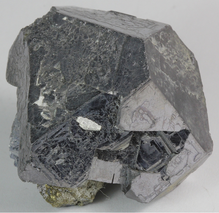


Indian Creek Mine, Indian Creek Subdistrict, Ebo, Washington County, Missouri, USA