 | | Journal (issue) | | WASHINGTON May 1, 2010 9:00 am to 5:00 pm Clark County P. U. D. Building 1200 Fort Vancouver Way Vancouver...followed by our update session to find N out what localities are actively producing material and are good...“Minerals in jasper/chert from the Biggs Area, Oregon” and Don Howard will be showing pictures of “What’s...Washington Interstate Bridge Oregon Ft. Vancouver Way Columbia River 2 IN MEMORY OF STAN JOHNSON...Howard, Editor 356 S. E. 44th Avenue Portland, Oregon 97215 e-mail: pogoette@hei.net DUES: $15 per year |  | Hill, Thelma P., Werner, Marian A., Horton, M. Julia (1967) Chemical composition of sedimentary rocks in Colorado, Kansas, Montana, Nebraska, North Dakota, South Dakota, and Wyoming. Professional Paper 561. US Geological Survey doi:10.3133/pp561 | Report (issue) | | are in pocket] PLATES 1-9. Maps showing sample localities 1. Groups A and C, common- and mixed-rock categories...samples by State and by age, stratigraphic unit, county, and classification group______ 192 204 205 205..."special-rock" category. Maps show distribution of sample localities by States, and triangular diagrams show the lithologic...distribution of localities from which the analyzed samples were taken indicate that many of the localities are in...Geological Survey. The other 10 percent are widely and county from which they were collected, and, fiscattered |  | Bramel, Hadley R., Heyl, George R., Cox, Manning W., Ransome, Alfred L., Eric, John H., Wyant, Donald G. (1948) Copper in California. Bulletin 144. California State Mining Bureau | Report (issue) | | Heyl 77""V" Zinc-Copper Deposits of the Big Bend Mine, Butte County, California, bv John H. Eric Geology...Geology of the Lilvama and Pioneer Mines, El Dorado County, and California, by Manning W. Cox, Donald C. Wyant...---"--7-1, George R. Heyl by George California, County, Newton Copper Mine, Amador R. Heyl and John H...H. Eric ""~V" Pemi Zinc-Copper Mine, Calaveras County, California, by George R. Hevl, Manning W. Cox,...Gravhouse Area, Amador County, California, by George T"" R. Heyl -;;— Calitornia, County, Calaveras Copperopolis |  | | Journal (volume) | | classes: 1. Mines and mineral resources of a given county (describing kind, character, distribution and extent...special report upon the gold resources of Siskiyou County. There is Averill, District SACRAMENTO FIELD...ft. vertically in Amador County and 9000 ft. inclined depth in Nevada County, for example) have been given...sluicing of top gravel on Yuba River near Smartville, Yuba County. Photo by Walter W. Bradley disquieting...the principal mines of the Mother Lode in Amador County during the last quarter of 1934. 'Depression miners |  | | Journal (volume) | | Colorado, electric mine-signal system.. 49 Olancho county, Honduras. Akin, A. D 167, 1018 Alabama, mineral...Company 624, 865, report American canyon, Humboldt county, Nevada, placer camp Enterprises In South America..."^^ MINING AND SCIENTIFIC PRESS Vol. 107 V. County of Greenlee Arkansas, Blue, and Magazine mountains...'.'.'.'.'. J' S?"^?- Western B ack Warrior Gila county, Arizona §!'^"^1' ptnT ."!• r^p"on' Sl«-<=''^^te''...^^^- ^^^' q^i HI ^"^ Zealan'd.'co'm: Blaine county, Idaho, 'geology' !!!!!!!!! Ispfe ,^;?i^r,ng |
|
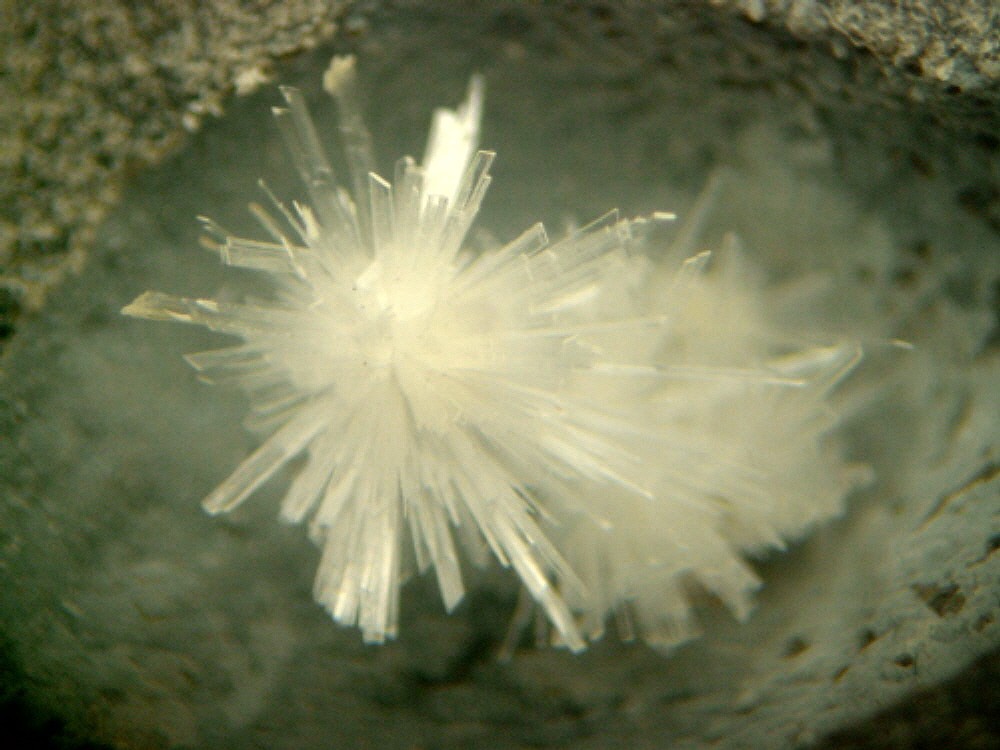


Big Cliff, Clackamas River localities, Clackamas County, Oregon, USA