| Classification |
|---|
|
| Species: | Kyanite |
| Formula: | Al2(SiO4)O |
| Confirmation |
|---|
|
| Validity: | Confirmed |
| Confirmation Methods: | Visually Identified |
| Data |
|---|
|
| Mineral Data: | Click here to view Kyanite data |
| Locality Data: | Click here to view Rock Brook, Harwinton, Litchfield County, Connecticut, USA |
| Photo Gallery | View Gallery (6 photos) |
| Data Identifiers |
|---|
|
| Mindat Occurrence Record ID: | 725453 |
| Long-form Identifier: | 1:3:725453:6 |
| GUID (UUID V4): | c3ff2703-9a11-4f51-a977-bf27261de018 |
| Nearest other occurrences of Kyanite |
|---|
|
|
| 2.7km (1.7 miles) | ⓘLead Mine Brook, Harwinton, Litchfield County, Connecticut, USA |
| 3.0km (1.9 miles) | ⓘHarwinton, Litchfield County, Connecticut, USA |
| 5.5km (3.4 miles) | ⓘThomaston Dam railroad cut, Thomaston Dam, Thomaston, Litchfield County, Connecticut, USA |
| 8.1km (5.0 miles) | ⓘThomaston, Litchfield County, Connecticut, USA |
| 10.5km (6.5 miles) | ⓘReynolds Bridge, Thomaston, Litchfield County, Connecticut, USA |
| 10.8km (6.7 miles) | ⓘTown Farm Road, Litchfield, Litchfield County, Connecticut, USA |
| 11.3km (7.0 miles) | ⓘTaine Mountain, Burlington, Hartford County, Connecticut, USA |
| 11.5km (7.1 miles) | ⓘWaterbury Road quarry, Thomaston, Litchfield County, Connecticut, USA |
| 12.7km (7.9 miles) | ⓘSoapstone quarry, Torrington (Wolcottville), Litchfield County, Connecticut, USA |
| 13.7km (8.5 miles) | ⓘHancock Brook Dam, Plymouth, Litchfield County, Connecticut, USA |
| References |
|---|
|
|
| Reference Search (possible matching items) |
|---|
 | | Report (issue) | | THE MIDDLE RADDAM QUADRANGLE, MIDDLESEX COUNTY, CONNECTICUT By Gordon P. Eaton and John.L. Rosenfeld...hornblende-ebiotite schist IPOr AMPHIBQLITE OF RESERVOIR BROOK dark-gray to black, massive to flaggy, mainly- schistose...ilmenite; and, locally, microcline. Less abundant rock types include biotiteoligoclase schist and gneiss...(the total of which constitutes 9.2 percent of the rock), and also biotite, locally with minor sphene, garnet...actinolite or hornblende-diopside calc-silicate rock, containing subordinate sphene, graphite, and rarely |  | | Journal (article/letter/editorial) | | Upland 1252 3. Section of rusty quartzite along brook 1J 3. Rocks and structures in Monadnock miles southwest...to join the Ashuelot River, and finally the Connecticut River. Their headwaters are typical youthful... the gorge of Minnewawa Brook east of Marlboro, and the gorge of Otter Brook southwest of East Sullivan...drumlins and outwash with only occasional exposures of rock. Possibly, when passing over Mt. Monadnock, the...moraines are present. The 3j-mile section of Otter Brook north of South Keene is in a broad preglacial valley |  | | Book | | Sciences, Natural Environment Research Council, Brook Road, Wormley, Godaiming, Surrey GU8 5UB, England...Resources, Inc., 287 Riverside Avenue, Westport, Connecticut 06880 Harold Williams, Memorial University...to sima? Did vast invasions of ultrabasic igneous rock radi¬ cally change to specific gravity? Was the...considerations, ex¬ tensive exposures of igneous rock on the gently sloping offshore flanks are rare and...the presumed principal source of oceanic igneous rock impinging against that margin. Several much smaller |
|

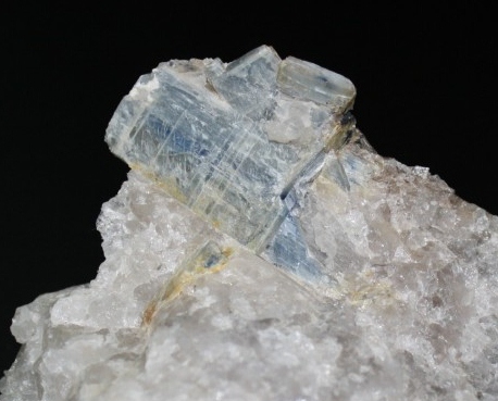

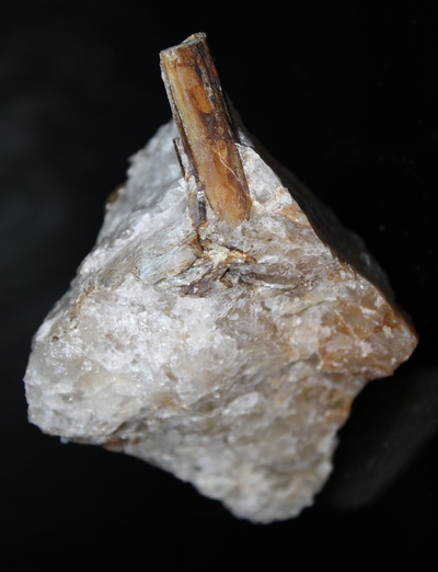


Rock Brook, Harwinton, Litchfield County, Connecticut, USA