| Classification |
|---|
|
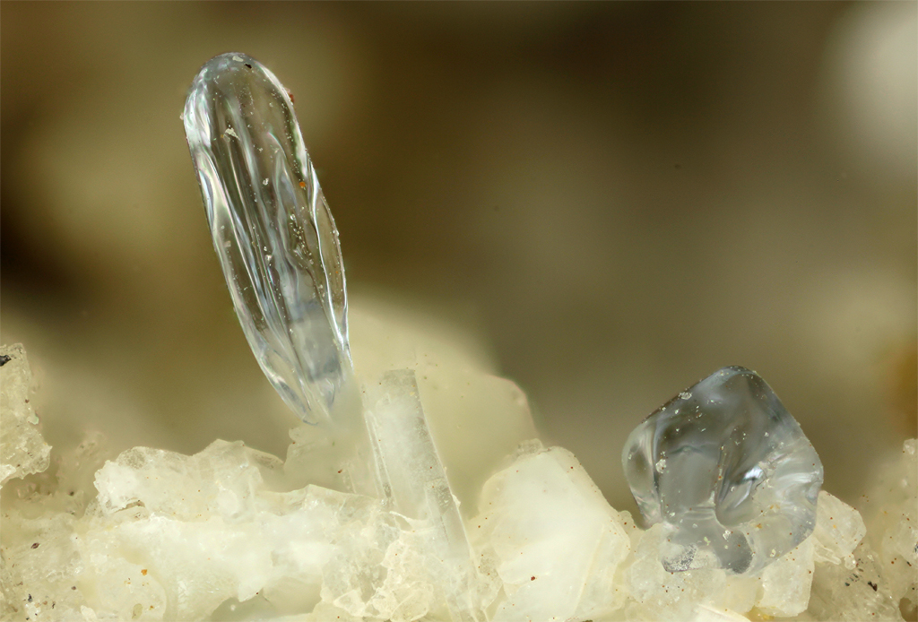
| Species: | Opal |
| Formula: | SiO2 · nH2O |
| Confirmation |
|---|
|
| Validity: | Confirmed |
| Confirmation Methods: | SEM-EDS |
| Data |
|---|
|
| Mineral Data: | Click here to view Opal data |
| Locality Data: | Click here to view Puy de Menoyre, Menet, Mauriac, Cantal, Auvergne-Rhône-Alpes, France |
| Data Identifiers |
|---|
|
| Mindat Occurrence Record ID: | 773982 |
| Long-form Identifier: | 1:3:773982:8 |
| GUID (UUID V4): | f5c509fc-d0c6-4d5d-8c65-a7053bca0f1a |
| Nearest other occurrences of Opal |
|---|
|
|
| 31.3km (19.5 miles) | ⓘSuper-Besse ski resort, Besse-et-Saint-Anastaise, Issoire, Puy-de-Dôme, Auvergne-Rhône-Alpes, France |
| 32.5km (20.2 miles) | ⓘPavin lake, Besse-et-Saint-Anastaise, Issoire, Puy-de-Dôme, Auvergne-Rhône-Alpes, France |
| 39.6km (24.6 miles) | ⓘLa Grange Mine, Meymac, Ussel, Corrèze, Nouvelle-Aquitaine, France |
| 45.5km (28.2 miles) | ⓘMineral spring, Saint-Nectaire, Issoire, Puy-de-Dôme, Auvergne-Rhône-Alpes, France |
| 55.4km (34.4 miles) | ⓘRoca-Neyra, Perrier, Issoire, Puy-de-Dôme, Auvergne-Rhône-Alpes, France |
| 56.2km (34.9 miles) | ⓘLa Violette farm, Saint-Beauzire, Brioude, Haute-Loire, Auvergne-Rhône-Alpes, France |
| 58.6km (36.4 miles) | ⓘCôte des Pompes, Saulzet-le-Chaud, Romagnat, Clermont-Ferrand, Puy-de-Dôme, Auvergne-Rhône-Alpes, France |
| 60.3km (37.5 miles) | ⓘFaverolles quarry, Val-d'Arcomie, Saint-Flour, Cantal, Auvergne-Rhône-Alpes, France |
| 63.2km (39.3 miles) | ⓘGergovie, La Roche-Blanche, Clermont-Ferrand, Puy-de-Dôme, Auvergne-Rhône-Alpes, France |
| 64.9km (40.3 miles) | ⓘPrudeux, Saint-Babel, Issoire, Puy-de-Dôme, Auvergne-Rhône-Alpes, France |
| References |
|---|
|
|


Puy de Menoyre, Menet, Mauriac, Cantal, Auvergne-Rhône-Alpes, France