| Locality type: | Town |
| Classification |
|---|
|
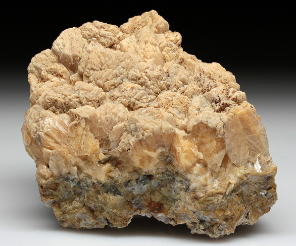
| Species: | 'Stilbite Subgroup' (not an IMA approved species) |
| Formula: | M6-7[Al8-9Si27-28O72] · nH2O |
| Comments: | In a vein in coarse gneiss, crystals to 2 cm tall. |
| Habit: | parallel aggregates of tabular crystals |
| Colour: | pale yellow |
| Abundance at site: | Extremely Rare |
| Confirmation |
|---|
|
| Validity: | Confirmed |
| Confirmation Methods: | Visually Identified |
| Data |
|---|
|
| Mineral Data: | Click here to view Stilbite Subgroup data |
| Locality Data: | Click here to view Plainfield, Hampshire County, Massachusetts, USA |
| Data Identifiers |
|---|
|
| Mindat Occurrence Record ID: | 777867 |
| Long-form Identifier: | 1:3:777867:4 |
| GUID (UUID V4): | 88b841cb-2875-45dc-b49b-be12fc082ecf |
| Nearest other occurrences of Stilbite Subgroup |
|---|
|
|
| 27.8km (17.3 miles) | ⓘCheapside Quarry (East Deerfield Quarry; Trew Corp. Quarry), Deerfield, Franklin County, Massachusetts, USA |
| 41.1km (25.6 miles) | ⓘLane Quarry, Northfield, Franklin County, Massachusetts, USA |
| 47.6km (29.6 miles) | ⓘLane & Son traprock quarries (Lane's Quarry), Westfield, Hampden County, Massachusetts, USA |
| 59.1km (36.7 miles) | ⓘGoodwin Dam (Hogback Dam), Hartland, Hartford County, Connecticut, USA |
| 63.9km (39.7 miles) | ⓘQuabbin Aqueduct shaft No. 10 locality, Hardwick, Worcester County, Massachusetts, USA |
| 65.9km (40.9 miles) | ⓘRoncari Quarry, East Granby, Hartford County, Connecticut, USA |
| 67.3km (41.8 miles) | ⓘBill's Brook Dam (Saville Dam), Barkhamsted, Litchfield County, Connecticut, USA |
| 76.1km (47.3 miles) | ⓘTalcott Mountain (King Phillip's Cave), Simsbury, Hartford County, Connecticut, USA |
| 78.8km (49.0 miles) | ⓘBellows Falls, Rockingham, Windham County, Vermont, USA |
| 80.6km (50.1 miles) | ⓘRockingham, Windham County, Vermont, USA |
| References |
|---|
|
|


Plainfield, Hampshire County, Massachusetts, USA