| Locality type: | Prospect |
| Classification |
|---|
|
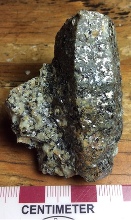
| Species: | Corundum |
| Formula: | Al2O3 |
| Confirmation |
|---|
|
| Validity: | Believed Valid |
| Associated Minerals Based on Photo Data: |
|---|
|
| Biotite | ⓘ2 photos of Corundum associated with Biotite at this locality. |
| Plagioclase | ⓘ2 photos of Corundum associated with Plagioclase at this locality. |
| Data |
|---|
|
| Mineral Data: | Click here to view Corundum data |
| Locality Data: | Click here to view Gilliam prospect, Madison County, Montana, USA |
| Photo Gallery | View Gallery (3 photos) |
| Data Identifiers |
|---|
|
| Mindat Occurrence Record ID: | 784534 |
| Long-form Identifier: | 1:3:784534:5 |
| GUID (UUID V4): | 76af8a6c-4b98-40d3-8b3a-9c627bddff46 |
| Nearest other occurrences of Corundum |
|---|
|
|
| 23.5km (14.6 miles) | ⓘNorris Deposit, Madison County, Montana, USA |
| 39.3km (24.4 miles) | ⓘBeartrap corundum deposit, Madison County, Montana, USA |
| 49.9km (31.0 miles) | ⓘGallatin Corundum Deposit (Montana Curundum; Fuller-Old Corundum), Gallatin Gateway (Salesville), Gallatin County, Montana, USA |
| 50.8km (31.6 miles) | ⓘElk Creek corundum deposit (Montana Mine; Gallatin deposit; Flying D), Gallatin County, Montana, USA |
| 52.9km (32.9 miles) | ⓘBozeman Corundum Co. Mine, Gallatin Gateway, Gallatin County, Montana, USA |
| 56.2km (34.9 miles) | ⓘSteward Mine, Butte Mining District (Summit Valley Mining District), Silver Bow County, Montana, USA |
| 65.8km (40.9 miles) | ⓘSweetwater Creek, Ruby Range, Madison County, Montana, USA |
| 76.3km (47.4 miles) | ⓘDry Cottonwood placer, Dry Cottonwood Creek, Orofino Mining District, Deer Lodge County, Montana, USA |
| 82.5km (51.3 miles) | ⓘCamp Creek Corundum Occurrence, Ruby Range, Beaverhead County, Montana, USA |
| 98.9km (61.5 miles) | ⓘBeaver Creek Occurrence, Gallatin County, Montana, USA |
| References |
|---|
|
|
| Reference Search (possible matching items) |
|---|
 | | Journal (article/letter/editorial) | | Montana Mineral Locality Index Downloaded by [University of Nebraska, Lincoln] at 20:00 09 April 2015...2015 K NOWN AS THE TREASURE STATE, Montana is rich in mineral and gemstone localities. The state motto...The middle third of the state is known as the Montana alkali province where the sediments have MICHAEL...Indian Queen mine ca. 1905 at Farlin, Beaverhead County. 208 ROCKS & MINERALS Downloaded by [University...mines at Butte in Silver Bow County and the Black Pine mine in Granite County have produced many fine crystal |
|


Gilliam prospect, Madison County, Montana, USA