| Locality type: | Adit |
| Classification |
|---|
|
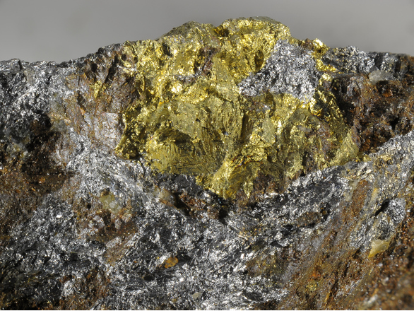
| Species: | Chalcopyrite |
| Formula: | CuFeS2 |
| Confirmation |
|---|
|
| Validity: | Believed Valid |
| Associated Minerals Based on Photo Data: |
|---|
|
| Arsenopyrite | ⓘ4 photos of Chalcopyrite associated with Arsenopyrite at this locality. |
| Quartz | ⓘ4 photos of Chalcopyrite associated with Quartz at this locality. |
| Pyrrhotite | ⓘ4 photos of Chalcopyrite associated with Pyrrhotite at this locality. |
| Gustavite | ⓘ3 photos of Chalcopyrite associated with Gustavite at this locality. |
| Gold | ⓘ2 photos of Chalcopyrite associated with Gold at this locality. |
| Acanthite | ⓘ2 photos of Chalcopyrite associated with Acanthite at this locality. |
| Matildite | ⓘ2 photos of Chalcopyrite associated with Matildite at this locality. |
| Sphalerite | ⓘ2 photos of Chalcopyrite associated with Sphalerite at this locality. |
| Bismuthinite | ⓘ2 photos of Chalcopyrite associated with Bismuthinite at this locality. |
| Bismuth | ⓘ2 photos of Chalcopyrite associated with Bismuth at this locality. |
| Data |
|---|
|
| Mineral Data: | Click here to view Chalcopyrite data |
| Locality Data: | Click here to view Schurfspitze (Egydi adit; Ochsenleiten), Lanisch, Pölla valley, Rennweg am Katschberg, Spittal an der Drau District, Carinthia, Austria |
| Data Identifiers |
|---|
|
| Mindat Occurrence Record ID: | 809566 |
| Long-form Identifier: | 1:3:809566:4 |
| GUID (UUID V4): | 0efbfc26-4b44-4baf-b0ad-dc0212846124 |
| Nearest other occurrences of Chalcopyrite |
|---|
|
|
| 0.9km (0.5 miles) | ⓘAloisi adit (Aloisy adit), Arsenic mine, Lanisch, Pölla valley, Rennweg am Katschberg, Spittal an der Drau District, Carinthia, Austria |
| 0.9km (0.6 miles) | ⓘStubenriegel (Herrenbau; Seekar), Lanisch, Pölla valley, Rennweg am Katschberg, Spittal an der Drau District, Carinthia, Austria |
| 1.1km (0.7 miles) | ⓘSchurfspitze (north slope), Silbereck - Altenbergkar area, Rotgülden, Muhr, Tamsweg District, Salzburg, Austria |
| 1.3km (0.8 miles) | ⓘSilbereck - Altenbergkar area, Rotgülden, Muhr, Tamsweg District, Salzburg, Austria |
| 2.5km (1.5 miles) | ⓘÖdenlanisch (Ebenlanisch), Pölla valley, Rennweg am Katschberg, Spittal an der Drau District, Carinthia, Austria |
| 2.6km (1.6 miles) | ⓘGfrererkar, Rotgülden, Muhr, Tamsweg District, Salzburg, Austria |
| 3.9km (2.4 miles) | ⓘArsenic mine, Lower Rotgülden lake, Rotgülden, Muhr, Tamsweg District, Salzburg, Austria |
| 4.9km (3.1 miles) | ⓘPetereck arsenic mine, Kölnbreinspitze - Lausnock area, Malta, Spittal an der Drau District, Carinthia, Austria |
| 4.9km (3.1 miles) | ⓘWastlkar, Kölnbreinspitze - Lausnock area, Malta, Spittal an der Drau District, Carinthia, Austria |
| 5.0km (3.1 miles) | ⓘWastlkar, Petereck, Malta, Spittal an der Drau District, Carinthia, Austria |
| References |
|---|
|
|


Schurfspitze, Lanisch, Pölla valley, Rennweg am Katschberg, Spittal an der Drau District, Carinthia, Austria