 | | Journal (issue) | | ; \ y \ ' A v:.; «# %,r ' , \ 4 ; . % . ' *> ‘ •■' Jfc ,-V .■*23r * $ ¥ YS a H ¥5 uJ® '...' d te ' ' *V J ~ ■ jgaafc£*V . 1 4 ':; -;. f ^ >• t * .i. * V X - , . ; n * *’yL ^ ...' ''• A * '. / T i l 'V T T y x r ("IflT A T T Tjl Wayne & Dona Leicht, 332 Forest Ave., # 8 , Laguna...fSc ly _ y I / Y _ j - 1 - J Open Tues.-Sat. 10-5. (Closed Sun.-Mon.) K )\n\A photo by Harold and Erica...2 . M in e r a l o g y o f th e R a p id C reek a n d B i g F is h R iv e r A r e a Y u k o n T e r |  | | Journal (article/letter/editorial) | | Tennessee Mineral Locality Index 300 T ennessee covers an area of 41,220 square miles in the southeastern...southeastern United States. It a 500-mile-long state situated mainly between 35° and 36.6° North latitude...Paleozoic TRAVIS A. PARIS 5604 Malmsbury Road Knoxville, Tennessee 37921 taparis@msn.com Figure 1 (top left)...Troost as the first state geologist. Troost identified a large number of mineral species in Tennessee and was... minerals, and mineral resources of the state. Mining has been an important part of Tennessee industry |  | | Report (issue) | | figure follow. See U.S. Geological Survey (1996) for a description of the information content of each field...The data presented here are maintained as part of a statewide database on mines, prospects and mineral...Distribution of mineral occurrences in the Big Delta 1:250,000-scale quadrangle, Alaska This and related...Resource Data File BD001 Site name(s): Banner Creek Site type: Mines ARDFno.: BD001 Quadrangle: BDB-5...accuracy: Banner Creek drains southward into the Tanana River. The approximate center of mining activity on |  | | Report (volume) | | of Colorado: A 100- Year Record By EDWIN B. ECKEL GEOLOGICAL SURVEY BULLETIN 1 1 14 A summary of the...______________ ______ 1 1 3 4 6 7 11 12 16 28 31 364 ILLUSTRATION PLATE 1. Map showing selected...________________________________ In pocket III NOTE Plate 1, map showing selected mineral localities and metallic... MINERALS OF COLORADO: A 100-YEAR RECORD By EDWIN B. EcKEL ABSTRACT This is a summary of the known...1858, when gold was discovered, through 1957 (with a few additions for 1958 and 1959) is supplemented by |  | | Book (volume) | | Phosphate deposits of the world. Vol. 1: Proterozoic and Cambrian phosphorites 1. Phosphates I. Cook, P.J. II...Vietnam India J3 /3 Pakistan Australia /2 /3 1/4 /4 Economic considerations /5 Proterozoic production...China 23 The BIFs and accompanying apatite Pine Creek Geosyncline 23 23 Stratigraphy 24 Tectonic setting...Formation Lower Member of the Doushantuo Formation Bed 1 46 Bed 2 Bed 3 46 46 Upper Member of the Doushantuo...(India) 80 Composition of phosphorites 8/ Depositional environment 8/ Phosphogenic episodes 86 References |  | | Journal (article/letter/editorial) | | \'l'I Q, 33° 0 1- I I I (/) ";lO (/) G'l ... (/) ~ (/) 32° Mineral Locality ~ Index LEWIS...jasper, semi-opal") in the Tennessee River Valley area near Huntsville, Madison County, the first such...resources in Alabama has long been a significant part of the state's mining industry. Since 1880, mineraI...gravel, iron ore, clay, marble, bauxite, and Figure 1. County map of Alabama. Courtesy U.S. Geological Survey...have been described from a variety of districts, sites, and prospects where mining and mineral exploration |  | | Report (issue) | | CLAY MINERALS OF THE FRONT RANGE: A FIELD GUIDE TO THE GEOLOGY, HISTORY, AND CLAY MINERALOGY OF THE CHIEFTAIN...Colorado 2002 U.S. DEPARTMENT OF THE INTERIOR GALE A. NORTON, Secretary U.S. GEOLOGICAL SURVEY CHARLES................................................... 8 Introduction ................................................... 47 Idaho Springs and Central City mining districts ....................... 47 Argo mill................................... 67 Nederland; mining in Boulder County ............................ |  | | Report (edition) | | L16P..'.SY \l 3 9 BULLETIN 41 Third Edition A Collector's Guide to Maine Mineral Localities by...of this publication may be reproduced, stored in a retrieval system, or transmitted, in any form or by...Buckfield, Maine. Mined in 1996 by Holden !Jrothers Mining and currently in the Jim Mann collection. Photo...I 900 ' s, showing Loren Merrill 's tourmaline mining operation at Mount Mica. Table of Contents CHAPTER...CHAPTER l. INTRODUCTION . . . . .I .I Format of locality descriptions How to use the maps . . . . . . |  | | Book (edition) | | large and so different in character that a companion volume became a necessiry. Not only have obscure and...interesting facts about the people involved in mining, current price lists of various stones, and numerous...geographical index, and all the material is keyed to a bibliography of over 2,600 entries, dating from colonial...understood, GEMSTO1'ES OF !':ORTH A.\1ERICA, Volumes I and II, will be welcomed as a unique and valuable reference...~onh America has developed into a major exponer rather than an imponer. A VAN NOSTRAND REINHOLD BOOK / |  | | Report (issue) | | CarboniferousPermian Lisburne Group, Northern Alaska By Julie A. Dumoulin, John F. Slack, Michael T. Whalen, and Anita...the USGS and its products: Telephone: 1 – 888 – ASK – USGS (1-888-275-8747) World Wide Web: http://www....................................................1 Introduction.........................................................................................1 Geologic Framework...................................................................................8 Ikpikpuk Well—North Slope........................ |  | | Report (issue) | | Flank of Black Hills, South Dakota By HARRY A. TOURTELOT and W. A. COBBAN SHORTER CONTRIBUTIONS TO GENERAL..._________ _ Stratigraphy and paleontology, by W. A. Cobban ______ _ Niobrara Formation ____________________________..._ L1 Petrology and origin of nodules, by Harry A. Tourtelot _ General statement on phosphate nodules..._________________ ------------ 4 1 2 2 2 2 3 4 4 5 6 7 7 7 8 11 11 11 11 11 Petflology and origin...18 21 ILLUSTRATIONS [Plates follow index] PLATE 1. Photographs of ammonites chiefly from base of Niobrara |  | | Report (issue) | | Australia, 1983 REF 349.994, N668c Noble, R. A. Catalogue of South Australian minerals, pe goPele...Bibliography. ISBN 0 7243 6247 9. ome Co \"] 1. Mineralogy—South Australia. |. Just, J. (Juri). Il...chrysocolla. INTRODUCTION The original idea for a catalogue of South Australian minerals came from Johannes...attracting many migrants and in 1841 he published a booklet called The Mineral Kingdom of South Australia...Colony’s Deputy Surveyor General, Thomas Burr, who had a keen interest in geology, published the first official |  | | Report (issue) | | Geologist and Head G. K. Guennel, Paleobotanist S. A. Friedman, Geologist Harold C. Hutchison, Geologist... Smith, Geologist Jack A. Sunderman, Geologist Petroleum Section T. A. Dawson, Geologist and Head G..................... 73 ILLUSTRATIONS Page Figure 1. Map of Indiana showing counties ....................................................................8 2. Generalized geologic map of Indiana .......................................11 TABLES Page Table 1. Stratigraphic position in Indiana of rocks mentioned |  | | Journal (issue) | | contents of The Picking Table are licensed under a Creative Commons Attribution-NonCommercial 4.0 International...Franklin, N.J. - Pre-meeting activities begin at 1:00 P.M. - Lectures at 2:00 P.M. Saturday Field Trip...is issued twice yearly; a March issue with news and the Spring Program, and a September issue with news...contents of The Picking Table are licensed under a Creative Commons Attribution-NonCommercial 4.0 International...Warren Miller, RD #1, Kennedy Mill Rd., Stewartsville, N.J. 08886 Richard C. Bostwick, RD #1, Box 497, Sussex |  | | Report (issue) | | report documents a large number of copper and uranium occur rences within one area of the Catskill Formation...mineralization occurs in only a very small percent age of the study area. The locations provided should...and other projects. Because this scenic area is endowed with a relatively large number of unusual mineral...travel to the area should be able to ap preciate these remarkable minerals. Similarly, the area provides amateur...Pennsylvania Geological Survey, Dr. Arthur A. Socolow, who has had a long-standing interest in the mineral |  | | Journal (issue) | | RECORD JANUARY-FEBRUARY 1995 • VOLUME 26 NUMBER 1 • $10 Wayne & Dona Leicht, 875 North Pacific Coast...-Mon.) p h o to by H aro ld and Erica Van Pelt, Los A ngele Editor & Publisher Wendell E. Wilson ineralogical...Roberts Geoi. Surv. of Canada Ottawa George W. Robinson Natl. Museums of Canada Ottawa, Ontario Abraham...Abraham Rosenzweig Tampa, FL J a n u a ry -F e b ru a ry 1995 V olum e T w en ty-six, N um ber O ne Associate...Germany Eric Offermann Arlesheim, Switzerland Jeffrey A. Scovil Phoenix, AZ Harold and Erica Van Pelt Los |  | | Book (edition) | | 1825 mining opened the West- . —Charles W. Henderson, 1933 MINERALS of New Mexico STUART A. NORTHROP...PRINTING PLANT ALBUQUERQUE, NEW MEXICO, U. S. A. FOR IVAH 1 CONTENTS PREFACE ix Scope and plan of...INTRODUCTION 1 Previous work Highlights in the history of New Mexico mineralogy and mining 3 5 Prehistoric...Republic of Mexico American occupation— New Mexico a Territory of the United States Statehood Summary...employment Citations of New Mexico mineral deposits 81 8 82 84 85 90 91 92 DESCRIPTIONS AND RECORDS OF |  | | Book | | M1P Van Nostrand Reinhold 17 Queen Street 2E7, Canada Australia Pty. Ltd. Mitcham, Victoria 3132, Australia...Berkshire, England 15 14 13 12 11 10 9 8 7 6 5 4 3 2 1 Library of Congress Cataloging in Publication...Robert Wallace Webb. Bibliography: p. Includes index. 1. Mineralogy -California. 2. Mines and mineral resources-...P. Blake, professor of mineralogy, geology and mining the at College of California, parent to the...the University of California, Berkeley, prepared as a report Board of Agriculture an “Annotated Catalog |  | | Journal (issue) | | amateur mineralogist Sir Arthur Russell (1878-1964), is a society of amateur and professional mineralogists...Leeds, LS18 4TG Printed by: St. Ives Graphic Media, (A division of St. Ives Group), Leeds, England. Published... Journal of the Russell Society Contents Volume 8, Part 2, 2005 PAPERS The mineralogy of Newhurst quarry...Weardale, Co. Durham Stephen Moreton Gearksutite, a second British occurrence, from the Ball Eye opencast... Co. Limerick Stephen Moreton and David I. Green A review of the occurrence of antlerite in the British |  | Palache, Charles, Berman, Harry, Frondel, Clifford (1951) The System of Mineralogy (7th ed.) Vol. 2 - Halides, Nitrates, Borates, Carbonates, Sulfates, Phosphates, Arsenates, Tungstates, Molybdates, Ect. John Wiley and Sons, New York. | Book (volume) | | Mineralogy. Revised by Cornelius By the late EDWARD A Textbook S. S. Sixteenth Edition in press. Hurlbut...was started in the summer of 1942, but after only a few months the two junior authors were drawn into...science of mineralogy suffered a tragic loss, and the writing of these volumes a lasting setback with his death...recognized inadequacies or errors in existing de- by a first-hand examination of authentic specimens. The...treatment of the several species that may constitute a series is easily effected in the case of binary systems | | | Book | | Birchmount Road Scarborough, Ontario Ml P 2E7, Canada Van Nostrand Reinhold Australia Pty. Ltd. 17 Queen...Wokingham, Berkshire, England 15 14 13 12 11 10 9 8 7 6 5 4 3 2 1 Library of Congress Cataloging in Publication...Robert Wallace Webb. Bibliography : p. Includes index. 1. Mineralogy - California. 2. Mines and mineral resources...P. Blake, professor of mineralogy, geology and mining at the College of California, parent to the University...University of California, Berkeley, prepared as a report to the State Board of Agriculture an "Annotated |  | | Report (issue) | | of Alae lava lake, Kilauea Volcano, Hawaii, by D. A. Swanson and D. W. Peterson Page C1 Petrology Fluid-inclusion...related to serpentinization, Union Bay, Alaska, by A. L. Clark and W. R. Greenwood . . . . . . Grain-size...evidence for volcanic origin of part of the Porters Creek Clay, Jackson Purchase region, western Kentucky...yttrofluorite in the White Cloud pegmatite, South Platte area, Colorado, by J. W. Adams and W. N. Sharp . . ....Lantz . . . . . . . . Thrust faults, Annette-Gravina area, southeastern Alaska, by H. C. Berg . . . . . . |  | | Report (issue) | | 1955 GEOLOGICAL SURVEY PROFESSIONAL Prepared as a cooperative effort ofthe Un-ited States Geological... SURVEY PROFESSIONAL PAPER 300 · Prepared as a cooperative effort ofthe United States Geological...carried on since 1944 · as a joint program of the Manhattan Engineer District and its successor, the U...materials has been so exhaustively studied in such a short period of time in the whole history of the geological...fissionable materials far beyond original expectations. A large body of valuable data has been added to the |  | | Report (issue) | | been found in the mining the nugget Jim, Placer County, California, in 1871 by a small girl in who...in California 30 Crestmore 36 Pegmatite gem area of southern California 46 Cerro Gordo 49 History...Counties of California: Minerals and mineral lists Mining Districts of California Unvalidated entries in...make the Centennial volume an historical as well as a scientific record of California mineralogy. The interest...and expanded. County lists published by Collins (1) pp. 40-64, in Murdoch and Webb (40), have been revised |  | | Report (issue) | | Geology and Mineral Deposits of the Roseland District of Central Virginia U.S. GEOLOGICAL SURVEY PROFESSIONAL... Geology and Mineral Deposits of the Roseland District of Central Virginia By NORMAN HERZ and ERIC R...1923Geology and mineral deposits of the Roseland district of central Virginia. (U.S. Geological Survey professional...Bibliography: p. Supt. of Docs, no.: I 19.16:1371 1. Geology-Virginia-Roseland Region. 2. Mines and mineral...dikes _______________ Gabbro ____________________ 1 1 I 3 3 4 4 5 5 6 6 7 10 10 11 II 11 12 12 12 12 13 |
|

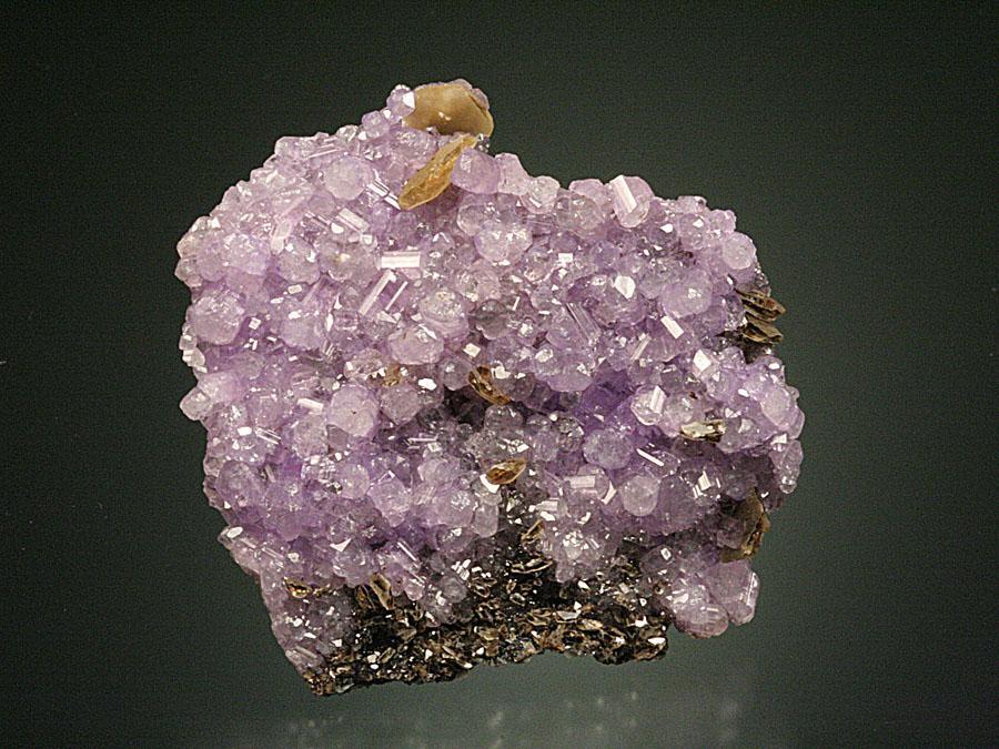


Locality 8, Kulan Camp, Rapid Creek, Dawson mining district, Yukon, Canada