| Classification |
|---|
|
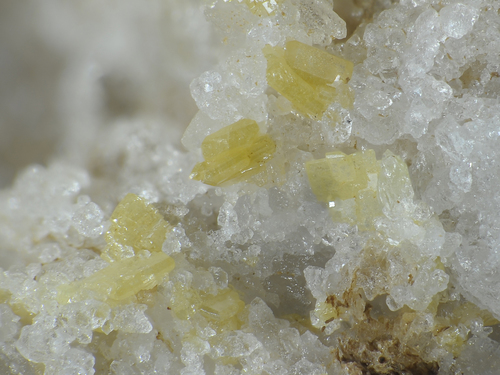
| Species: | Wulfenite |
| Formula: | Pb(MoO4) |
| Confirmation |
|---|
|
| Validity: | Believed Valid |
| Data |
|---|
|
| Mineral Data: | Click here to view Wulfenite data |
| Locality Data: | Click here to view Steirische Kalkspitze (incl. Akarscharte; Akharscharte), Giglach lakes, Giglach valley, Schladming, Liezen District, Styria, Austria |
| Photo Gallery | View Gallery (4 photos) |
| Data Identifiers |
|---|
|
| Mindat Occurrence Record ID: | 864525 |
| Long-form Identifier: | 1:3:864525:8 |
| GUID (UUID V4): | 56695387-7e03-4301-b2a0-0e2709d58086 |
| Nearest other occurrences of Wulfenite |
|---|
|
|
| 1.0km (0.6 miles) | ⓘLungauer Kalkspitze (incl. Znachsattel; "Im Kalk"), Weißpriach, Tamsweg District, Salzburg, Austria |
| 5.0km (3.1 miles) | ⓘDuisitzkar, Obertalbach valley, Schladming, Liezen District, Styria, Austria |
| 6.6km (4.1 miles) | ⓘEschach Alp (Eschachboden; Martinlager), Obertalbach valley, Schladming, Liezen District, Styria, Austria |
| 23.9km (14.8 miles) | ⓘStüblbau Mine, Gold mines, Schellgaden, Muhr, Tamsweg District, Salzburg, Austria |
| 25.3km (15.7 miles) | ⓘPrahmleiten adit (Pramleiten; Brandleiten), Gold mines, Schellgaden, Muhr, Tamsweg District, Salzburg, Austria |
| 25.9km (16.1 miles) | ⓘRamsbach mines, Zanaischg, Pölla valley, Rennweg am Katschberg, Spittal an der Drau District, Carinthia, Austria |
| 26.1km (16.2 miles) | ⓘKnappenlöcher, Zanaischg, Pölla valley, Rennweg am Katschberg, Spittal an der Drau District, Carinthia, Austria |
| 27.2km (16.9 miles) | ⓘMuritzenkar, Haderlingspitze, Muritzen valley, Rotgülden, Muhr, Tamsweg District, Salzburg, Austria |
| 27.7km (17.2 miles) | ⓘStubenriegel (Herrenbau; Seekar), Lanisch, Pölla valley, Rennweg am Katschberg, Spittal an der Drau District, Carinthia, Austria |
| 29.7km (18.4 miles) | ⓘKölnbreinkar, Kölnbreinspitze - Lausnock area, Malta, Spittal an der Drau District, Carinthia, Austria |
| References |
|---|
|
|


Steirische Kalkspitze, Giglach lakes, Giglach valley, Schladming, Liezen District, Styria, Austria