| Locality type: | Open-Cast Mine |
| Classification |
|---|
|
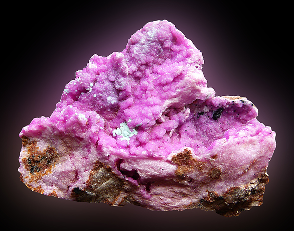
| Species: | Calcite |
| Formula: | CaCO3 |
| Confirmation |
|---|
|
| Validity: | Believed Valid |
| Associated Minerals Based on Photo Data: |
|---|
|
| Heterogenite | ⓘ1 photo of Calcite associated with Heterogenite at this locality. |
| Cobalt-bearing Calcite | ⓘ1 photo of Calcite associated with Cobalt-bearing Calcite at this locality. |
| Data |
|---|
|
| Mineral Data: | Click here to view Calcite data |
| Locality Data: | Click here to view Kansalawile Mine, Tenke-Fungurume area, Lualaba, DR Congo |
| Data Identifiers |
|---|
|
| Mindat Occurrence Record ID: | 870219 |
| Long-form Identifier: | 1:3:870219:7 |
| GUID (UUID V4): | b09223a9-9ecf-44ce-a5dd-c0bd540816da |
| Nearest other occurrences of Calcite |
|---|
|
|
| 3.7km (2.3 miles) | ⓘMambilima Mine, Tenke-Fungurume area, Lualaba, DR Congo |
| 6.7km (4.2 miles) | ⓘTenke-Fungurume area, Lualaba, DR Congo |
| 11.5km (7.1 miles) | ⓘFungurume 88 deposit, Fungurume deposit, Tenke-Fungurume area, Lualaba, DR Congo |
| 21.4km (13.3 miles) | ⓘKakanda deposit, Lubudi, Lualaba, DR Congo |
| 23.7km (14.7 miles) | ⓘKakanda South Mine, Kakanda deposit, Lubudi, Lualaba, DR Congo |
| 37.5km (23.3 miles) | ⓘKabolela Mine, Lubudi, Lualaba, DR Congo |
| 43.9km (27.3 miles) | ⓘShangulowé Mine, Kambove, Kambove Territory, Haut-Katanga, DR Congo |
| 46.0km (28.6 miles) | ⓘKamfundwa Mine, Kambove, Kambove Territory, Haut-Katanga, DR Congo |
| 47.1km (29.3 miles) | ⓘKamoya South II Mine, Kamoya, Kambove, Kambove Territory, Haut-Katanga, DR Congo |
| 48.5km (30.2 miles) | ⓘKambove West Mine, Kambove, Kambove Territory, Haut-Katanga, DR Congo |
| References |
|---|
|
|
| Reference Search (possible matching items) |
|---|
 | | Journal (article/letter/editorial) | | Proterozoic Mines Series, Tenke-Fungurume Cu–Co district, Democratic Republic of Congo I. Fay & M. D. Barton...sediment-hosted stratiform Cu–Co deposits in the Tenke-Fungurume district of the Central African Copperbelt...precipitate separately. Thus, modern ore distribution at Tenke- Editorial handling: H. Frimmel I. Fay (*) : M...85721-0077, USA e-mail: fay1@email.arizona.edu Fungurume results both from original hypogene lithologyand...across the southeastern Democratic Republic of Congo into northern Zambia (Fig. 1a, b), contains some |  | | Report (issue) | | .pdf. Cover. Underground photo of the Skuterud Mine in Norway showing pink secondary erythrite (a hydrated.......................................F13 Typical Mine Life..........................................................................................F16 Mine Waste Characteristics.........................................................................F18 Mine Closure.....................................................F2 F2. Bar chart showing world cobalt mine and refinery production and apparent consumption |  | | Book | | label: Aerial view of the Bingham Canyon copper mine, Kennecott Utah Copper, September 2003. Photo courtesy...Cu-U-Au-Ag Deposit, South Australia Geology of the Tenke-Fungurume SedimentHosted Strata-Bound Copper-Cobalt District...District, Katanga, Democratic Republic of Congo Dzhezkazgan and Associated Sandstone Copper Deposits...Discovery of a Jurassic porphyry copper belt, Pangui area, southern Ecuador: Society of Economic Geologists...Tunnels Au-Ag-Zn-Pb deposit, Montana, United States (mine now exhausted). 1971: Recognized control of ore |  | | Journal (issue) | | ...............363 by C. J. Stefano The Nakhlak Mine, Anarak District, Esfahan Province, Iran.......... Hickox, Jr. Wally Mann Keith and Diane Brownlee Dr. Nikolas Golosow William B. (Bill) Wray Herb & Monika...Budil (2023) SPONSORING ORGANIZATIONS Houston Area Mineral Society (HAMS) (2009–2023) Mineral Association...species hauckite (type locality: the Sterling Hill mine) was named in his honor in 1980, in recognition...Robert (left) and Richard Hauck in the Sterling mine (2008). J.R. Glover photo. American Mineral Heritage |  | | Report (issue) | | courtesy of the U.S. Department of Energy Western Area Power Administration. Back cover. A handful of stibnite...population growth and the change in supporting land area from 3500 B.C. to 2100 A.D., with projections to....B3 Graph showing dates associated with all the mine sites on the U.S. Environmental Protection Agency’s...production, U.S. apparent consumption, and U.S. mine production of antimony from 1900 to 2012..........related deposit types, gelogic map of Spor Mountain area in Utah, photograph of beryllium tuff at Spor Mountain |
|


Kansalawile Mine, Tenke-Fungurume area, Lualaba, DR Congo