| Locality type: | Deposit |
| Classification |
|---|
|
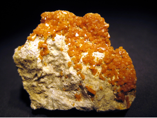
| Species: | Wulfenite |
| Formula: | Pb(MoO4) |
| Confirmation |
|---|
|
| Validity: | Believed Valid |
| Associated Minerals Based on Photo Data: |
|---|
|
| Hydrozincite | ⓘ2 photos of Wulfenite associated with Hydrozincite at this locality. |
| Baryte | ⓘ1 photo of Wulfenite associated with Baryte at this locality. |
| Hemimorphite | ⓘ1 photo of Wulfenite associated with Hemimorphite at this locality. |
| Data |
|---|
|
| Mineral Data: | Click here to view Wulfenite data |
| Locality Data: | Click here to view Jaukenhöhe, Dellach, Hermagor District, Carinthia, Austria |
| Photo Gallery | View Gallery (20 photos) |
| Data Identifiers |
|---|
|
| Mindat Occurrence Record ID: | 911961 |
| Long-form Identifier: | 1:3:911961:1 |
| GUID (UUID V4): | f62db307-239c-41b5-adb0-dfd31f59510a |
| Localities for Wulfenite in this Region |
|---|
|
| South slope, Jaukenhöhe, Dellach, Hermagor District, Carinthia, Austria |
| Nearest other occurrences of Wulfenite |
|---|
|
|
| 0.2km (0.1 miles) | ⓘSouth slope, Jaukenhöhe, Dellach, Hermagor District, Carinthia, Austria |
| 2.2km (1.4 miles) | ⓘPlonalmlacke, Dellach im Drautal, Spittal an der Drau District, Carinthia, Austria |
| 4.8km (3.0 miles) | ⓘKolm (Scheinitzen), Dellach im Drautal, Spittal an der Drau District, Carinthia, Austria |
| 9.5km (5.9 miles) | ⓘBleiwand, Kreuzberg, Plöcken pass area, Kötschach-Mauthen, Hermagor District, Carinthia, Austria |
| 25.9km (16.1 miles) | ⓘTscherniheim, Weißensee, Spittal an der Drau District, Carinthia, Austria |
| 31.2km (19.4 miles) | ⓘZuchengraben (Suchengraben; Zauchengraben; Zuchen), Graslitzen (Gradlitzen; Palascha), Förolach, Hermagor-Pressegger See, Hermagor District, Carinthia, Austria |
| 34.6km (21.5 miles) | ⓘPaternioner Alp, Kreuzen, Paternion, Villach-Land District, Carinthia, Austria |
| 34.9km (21.7 miles) | ⓘTorleiten (incl. Feldseescharte), Wurten, Flattach, Spittal an der Drau District, Carinthia, Austria |
| 36.2km (22.5 miles) | ⓘBleiriesen (Bleiriese), Golsernock, Stockenboi, Villach-Land District, Carinthia, Austria |
| 38.5km (23.9 miles) | ⓘKELAG water tunnel, Großkirchheim, Spittal an der Drau District, Carinthia, Austria |
| References |
|---|
|
|


Jaukenhöhe, Dellach, Hermagor District, Carinthia, Austria