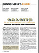
 | Huizing, Terry E., Richards, R. Peter, Clifford, Janet H., Cook, Robert B. (2017) Connoisseur's Choice: Calcite from the American Midwest, Gordonsville Mine, Carthage, Smith County, Tennessee. Rocks & Minerals, 92 (1) 46-63 doi:10.1080/00357529.2017.1241690 | Journal (article/letter/editorial) | | American Midwest Gordonsville Mine, Carthage, Smith County, Tennessee C alcite is ubiquitous in the American...Tennessee Lead-Zinc district near Carthage in Smith County. Calcite from this locality is noted for high luster...ancient basins and plateaus. The Southeastern Missouri district includes the Old Lead Belt (on right)...oldest rocks in the Midwest, which are composed of chert and iron oxides that were chemically precipitated...cm tall, from the Ben Hogan quarry in Lawrence County, Arkansas. Terry Huizing specimen (No. TEH 273) |  | | Catalog/List | | AURICHALCITE - BISBEE: Southwest Mine, Cochise County, Bisbee, Arizona: Exceptional baby blue to deep...AURICHALCITE - 79 MINE: 79 Mine, Banner District, Gila County, Arizona: Delicate radiating acicular and lathlike...Morenci Mine, Clifton-Morenci District, Greenlee County, Arizona: Excellent specimens of this great deep...supply. CALCITE - BISBEE: Southwest Mine, Cochise County, Bisbee, Arizona: AWESOME! Exquisite masses of...STRONTIANITE AND CALCITE: Mandata Quarry, Cumberland County, Pennsylvania. An awesome new find from late last |  | | Journal (article/letter/editorial) | | Oklahoma, Kansas, and Missouri and the world-class Viburnum Trend of southeastern Missouri. Deposits in both...districts. THE TRI-STATE DISTRICT History of the Missouri Portion of the Tri-State District The Tri-State...Tri-State district, extending from southwestern Missouri through Kansas into Oklahoma (fig. l), was one of the...small-scale mining in 1849 on Turkey Creek in Joplin, Missouri (Dressel 1989). The history of the district is...titled “Minerals of the Vanadinite Mine, Mohave County, Arizona.” 400 ROCKS 81 MINERALS rized in Lasnianis |  | | Journal (article/letter/editorial) | | its location at the junction of three states. In Missouri, the district contains the Granby, Joplin and...and by the introduction of silica, which formed chert. The openings in which mineralization took place...mining districts in the world are in southeastern Missouri, where the Old Lead Belt district near Bonne Terre...district is located east of Nashville in Smith County, Tennessee, and extends to the northeast and southwest...of the Harris Creek Fluorspar District, Hardin County, Illinois. Rocks & Minerals 63,210-226. PRESMYK |  | | Report (chapter) | | History of Mining in the Southeast Missouri Lead District and Description of Mine Processes, Regulatory...Mining Issues in Southeastern Missouri Edited by Michael J. Kleeschulte Missouri Department of Natural Resources...............................................7 Missouri Lead Study....................................................10 Early Mining in Southeastern Missouri..................................................................................10 Southeast Missouri Lead District................................ |  | | Catalog/List | | Laranjeiras Mine, Minas Gerias,Brazil Magnet Cove,Arkansas,USA ½ x½ £1.50 5mm£3 Hannover Cove.St Agncs, Comwall...Mongolia. P.D.WellNo I , near Ajo, Pima lxl £4 County, Arizona , U.S.A Ribane Mine, Mozambique £8 Mt...Close, Cobham.Surrey England KT! I 2NL Boron, Kem County,Califomia U.S.A Madagascar Ix! £2 lxl £7. S0...ltaly lxl £5 Boghill Road Quarry, Glengonnley, County Antrim, Yaknl Mine,Bigndic, Turkey 1/,x½ £S ½...2x2 £6 Davis Mountains,Maricopa 5mm £3 County,Arizona, USA Hilarion Mine , Lnurium,Greecc ½ • £3 lxl |  | | Journal (article/letter/editorial) | | Missouri VISIT0 R INFORMAT1ON Compiled by WILLIS D. SMITH 1413 N. Elizabeth Avenue Calverton Park, Missouri...basically divided into two distinct regions by the Missouri River. The northern part of the state was covered...visit; for more specific information, write the Missouri Division of Tourism, Truman State Office Building...GEOLOGIC INTEREST State Parks and Historic Sites Missouri has forty-six state parks and thirty-three historic...geologic feature, State parks are managed through the Missouri Department of Natural Resources, Division of State |  | | Book (edition) | | MISSOURI HANDBOOK NUMBER ONE THE COMMON ROCKS AND MINERALS OF MISSOURI W. D. KELLER UNIVERSITY OF...OF MISSOURI PRESS MISSOURI HANDBOOK NUMBER ONE THE COMMON ROCKS AND MINERALS OF MISSOURI WrDsKELEER... OF MISSOURI PRESS * COLUMBIA ABOUT THIS BOOK The Common Rocks and Minerals of Missouri was first...first published in 1945 as part of the Missouri Handbook series, a project of the College of Arts and...1948 and 1961. Subsequently, the University of Missouri Press became the publisher of the series. Although |  | | Report (issue) | | information iuly 18 circular 1967 STATE OF MISSOURI DIVISION OF WC HAYES DEPARTMENT GEOLOGICAL... AND AND WATER DIRECTOR RESOURCES ROLLA MISSOURI Digitized by the Internet Archive in 2023 with...fgeO OOOj err , BIBLIOGRAPHY OF THE GEOLOGY OF MISSOURI 1966 by Jerry D. Vineyard / INFORMATION CIRCULAR...CIRCULAR NO. 18 July, 1967 STATE OF MISSOURI Department of Business and Administration Division of GEOLOGICAL...Director and State Geologist Rolla, Missouri STATE OF MISSOURI Warren E. Hearnes, Governor DEPARTMENT |  | | Report (volume) | | GEOLOGICAL SURVEY OF MISSOURI. ARTHUR WINSLOW, STATE GEOLOGIST. VOL. II . A REPORT 0:N THE IRON...IRON ORES OF MISSOURI FROM FIELD WORK PROSECUTED DURING THE YEARS T891 and 1892. W i th 6 2 Illu s trat...Polk County. LETTER OF TRANSMITTAL. 0FFICI~ OF THE GEOLOGICAL SURVEY,} JEFFERSON CITY, MISSOURI, December...transmit, herewith, a Report upon the Iron Ores of Missouri, by Mr. Frank L. Nason, assistant geologist. Dnring... the two important iron mines of southeastern Missouri, the Iron IIIOuntain and Pilot Knob deposits, |  | | Journal (article/letter/editorial) | | found here The Rock and Mineral Club of Lower Bucks County, Fairless Hills, is featuring in its bulletin,...Mineral and Gem Society, Eastchester The St. Lawrence County Rock and Mineral Club, Potsdam, demonstrated the...collecting areas and nearby wetlands. The Wayne County Gem and Mineral Club, Marion, made a field trip...trip to Wards in Rochester The Tomp kins County Gem and Mineral Club, Ithaca, is planning the purchase...Department of Fairleigh Dickinson University. The Bergen County Mineral ogy and Paleontology Society, Paramus |  | | Catalog/List | | TOTAL WRECK WULFENITE: Total Wreck Mine, Pima County, Arizona; Nice butterscotch to near clear thumbnails...at $15.00 each. BROOKITE: Magnet Cove, Garland County, Arkansas; Dipyramidal thumbnail crystals mounted...Hill, Calaveras River, Valley Springs, Calaveras County, California: Really neat little buggers for sure...ANDRADITE GARNET: Hans Garnet Mine, Paradise, Plumas County, California: Very showy deep red garnets on matrix...WULFENITE: 320 foot level, Glove Mine, Santa Cruz County, Arizona. Black coloration is caused by included |  | | Report (volume) | | 250-12,460 ft, sec. 14, T. 45 S., R. 27 E., Lee County, Fla. Named for the nearby Able Canal. The Able...H-20, northwest of Wattsville, northern Accomack County, Va. Reference sections: facies E and F, sand pits...Wattsville, Persimmon Point, and Accomack, Accomack County, Va. The informal Accomack beds of Mixon and others...and west of the Ames Ridge shoreline in Accomack County, Va., and are well developed from Wallops Station...Turnpike exchange, Annandale quadrangle, Fairfax County, Va. The Accotink Schist, here named, is the lower |  | | Journal (article/letter/editorial) | | page): Galena, St. Joseph Lead mine, Viburnum, Missouri, Viburnum Trend district; 6 cm on edge; James...the mines of the Viburnum Trend in southeastern Missouri accounted for 90 percent of the United States'...Beales (1967). The source of lead in southeastern Missouri is described by Doe and Delevaux (1972). M V T...of the Crescent Formation, Robertson Pit, Mason County, Washington" (January/February 1988). From 1961...Magmont deposit, Viburnum Trend, southeastern Missouri. 91° 90° Figure 9: Map of the Upper Mississippi |  | | Report (issue) | | EFFECTS ON STREAM DISTURBANCE IN THE OZARK PLATEAUS, MISSOURI U.S. GEOLOGICAL SURVEY Open-File Report 94-333...94-333 Prepared in cooperation with the MISSOURI DEPARTMENT OF CONSERVATION HISTORICAL LAND-USE CHANGES...EFFECTS ON STREAM DISTURBANCE IN THE OZARK PLATEAUS, MISSOURI By ROBERT B. JACOBSON and ALEXANDER T. PRIMM U...in cooperation with the MISSOURI DEPARTMENT OF CONSERVATION Rolla, Missouri 1994 U.S. DEPARTMENT OF...Survey 1400 Independence Road Mail Stop 200 Rolla, Missouri 65401 U.S. Geological Survey Earth Science Information |  | | Journal (article/letter/editorial) | | SHERWOOD 106A East 25th, P. 0. Box 436 Oak Grove, Missouri 64075-0436 Downloaded by [Brown University Library]...Louis, Missouri 63129-2704 Figure 1. Counties in Missouri. N o comprehensive list of Missouri mineral...found in Missouri; two of these, fletcherite and starkeyite, were first described from Missouri mines....location a~ included at the end of each entry. Adair County Chariton River (40-04-05N 92-4 I -23W). septarian...septarian concretions about 2 miles north of the Macon county line. CALCITE crystals enclosing bundles of acicular |  | | Journal (article/letter/editorial) | | too freely from my manuscript in so doing. On in Missouri, studying the crystalline rocks and January 29...would greatly enhance the value of VIII. of the Missouri Geological Survey. Much the report to incorporate...h e request of Mr. Winslow for m y chapter on Missouri stratigraphy t o accompany t h e Paleontology...BY CHARLESR. KEYES.\ The crystalline rocks of Missouri are irregularly distributed over nn area nearly...the northeast they are found in Ste. Genevieve county nearly thirty miles from Pilot Knob. On the east |  | | Catalog/List | | 00. CRYSTALLINE CUPRITE: Ray Central Mine, Pinal County, Arizona: Excellent small crystalline specimens...each. BOTRYOIOAL HEMATITE· lshpeming, Marquetta County, Michigan: 2 to 4 inch specimens from this famous...HEM/MORPH/TEANO CHRYSOCHOLLA: 79 Mine, Banner District, Gita County, Arizona: Another oldie, clear to white hemimorphite... 2 •• , MOHA WK/TE: Mohawk Mina; Keweenaw County, Michigan: From an old collection, this rare copper-nic...quick sale. ROSAS/TE: Silver Bill Mi ne, Cochise County, Arizona. Nice 1x1 to 2x2 inch specimens of bright |  | | Report (issue) | | Region Rosiclare, Illinois to Ironton and Viburnum, Missouri June 30-July 8, t 989 Field Trip Guidebook Tt47...Peabody Drive Champaign, IL 61820 Eva B. Kisvarsanyi Missouri Dept. of Natural Resources Div. of Geology and...Dept. of Geology and Geophysics University of Missouri - Rolla Rolla, MO 65401 Associate Leaders: James...Dept. of Geology and Geophysics University of Missouri - Rolla Rolla, MO 65401 IGC FIELD TRIP T147:...Richard D. Hagni 4 COVER The Arch, St. Louis, Missouri. lIllinois State Geological Survey, Urbana, Illinois |  | | Report (issue) | | deposits of selected mines in the VIBURNUM TREND, MISSOURI ~ _. 0 0 w (!) a: ..J <{ a: ::> I~ z...DEPOSITS OF SELECTED MINES IN THE VIBURNUM TREND, MISSOURI: Mo. Dept. of Nat. Resources, Geological Survey... CONTENTS 1 introduction to the southeast missouri lead district page 3 stratigraphic and facies...deposits of selected mines in the VIBURNUM TREND, MISSOURI J ,. . ~:·~ ;i. ' 1'......,,,11o.-~ l'o.,.....The Viburnum Trend ore deposits in southeastern Missouri contain the largest reserves of lead and zinc | 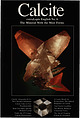 | | Report (issue) | | International, LLC P.O. Box 263, East Hampton, CT 06424, USA Phone 1.860.267.1512; fax 1.860.267.7225 www.lapisint...at the Crystal River quarry, Lecanto in Citrus County Florida. Collection Francis Benjamin; photo Jeff...twin on {1 OTI} from the Leiping mine, Guiyang County, Hunan, China. Collection Frederic Escaut; photo...on (0001} from St. Clair Lime quarry, Sequoyah County, Oklahoma. Collection Terry Huizing; photo Jeff...CHRISTIAN WEISE VERLAG, GERMANY AND LAPIS INTERNATIONAL, USA To Our Readers: As we established our company, |  | | Report (issue) | | THE OZARK PLATEAUS AQUIFER SYSTEM IN PARTS OF MISSOURI, ARKANSAS, OKLAHOMA, AND KANSAS U.S, GEOLOGICAL...the Ozark Plateaus Aquifer System in Parts of Missouri, Arkansas, Oklahoma, and Kansas By J.L. IMES and...the Ozark Plateaus aquifer system in parts of Missouri, Arkansas, Oklahoma, and Kansas / by J.L. Imes...water levels in observation well in Phelps County, Missouri Graph showing effect of precipitation on water...water levels in observation well in Howell County, Missouri Maps showing: 55. Selected springs of the |  | | Report (issue) | | spectrum of the geologic features of Illinois and Missouri that range in age from Precambrian to Quaternary...at the Jubilee Lodge stop; cobbly limestone and chert overlying crudely stratified LLINOIS DEPAfiTMEW...Editor's The Message Francois Mountains of Missouri: St. Window to the Mesoproterozoic James A...DESCRIPTIONS Stop 1-1 : Graniteville Granite at the Missouri 3 Red Quarry Location Outcrop Description...Mountain Ignimbrite and Skrainka Basalts Along Missouri Highway 72 Location Outcrop Description Stop |  | | Report (volume) | | Assessment of the Springfield 1 o x 2° Quadrangle, Missouri, As Appraised in September 1985 Geology and...Assessment of the Springfield 1 o x 2° Quadrangle, Missouri, As Appraised in September 1985 Edited by JAMES...WALDEN P. PRAlT Prepared in cooperation with the Missouri Department of Natural Resources, Division of Geology...assessment of the Springfield 1°X2° quadrangle, Missouri, as appraised in September 1985 I edited by James...Mines and mineral resources-Missouri-Springfield Region. 2. Geology-Missouri-Springfield Region. I. Martin |  | | Report (volume) | | ............................................. Missouri.............................................................................................. Missouri.................................................14. Sketch showing occurrence of breccia ore at Reynolds Mountain... 15. Sketch showing distribution of...while the California ores are concentrations within chert lenses of material originally present in a disseminated...siliceous ores containing sand grains and sandstone or chert fragments. The crude mining methods that naturally |
|


