 | | Report (issue) | | MINERALS OF NEVADA MINERALS OF NEVADA Peer Hen By CASTOR oan eGORY.C.oFER DOCK NEVADA AND BUREAU... UNIVERSITY Reno & Las Vegas OF NEVADA PRESS GEOLOGY Nevada Bureau of Mines and Geology Special...University of Nevada Press, Reno, Nevada 89557 USA Copyright © 2004 by University of Nevada Press Photographs...otherwise noted Map of Mining Districts and significant mineral occurrences of Nevada by Nevada Bureau of Mines...Cataloging-in-Publication Data Castor, Stephen B, Minerals of Nevada / Stephen B. Castor and Gregory C. Ferdock.— Ist | | | Report (issue) | | MINERALS OF NEVADA MINERALS OF NEVADA STEPHEN B. CASTOR and G R EGOR Y C . F E R D OC K l NEVADA BUREAU...association with the UNIVERSITY OF NEVADA PRESS Reno & Las Vegas Nevada Bureau of Mines and Geology Special...University of Nevada Press, Reno, Nevada 89557 USA Copyright© 2004 by Uni versity of Nevada Press Photographs...Districts and si gnificant minernl occurrences of Nevada by Nevada Bureau of Mines and Geology All rights reserved...-Publ ication Dat,i Castor, Stephen B. Minerals of Nevada/ Stephen B. Castor and Gregory C. Ferdock.- rst |  | | Book | | f. MIMING DISTRICTS and MINERAL RESOURCES of NEVADA by FRANCIS CHURCH LINCOLN i r r i i ; %■... ; 'jxt . 1 — \ MINING DISTRICTS and MINERAL RESOURCES of NEVADA by FRANCIS CHURCH LINCOLN...LINCOLN 0 ll ; RENO NEVADA NEWSLETTER PUBLISHING COMPANY 1923 PREFACE Earlier Works. The object of...infor mation concerning the mining districts and mineral resources of Nevada. No comprehensive work of...peared for a number of years. In the early days of Nevada min ing, from 1866 to 1878, the field was covered | 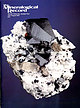 | | Journal (issue) | | Cooper Nottingham, England Anthony R. Kampf L.A. County Mus. of Nat. Hist. Los Angeles, CA Joseph A. Mandarino...in y u lite from the W illard m in e, P ershing County, N e v a d a ....................................Record, volume 31, July-August, 20C Sweet Home Mine Special Issue. Since living in Connecticut I have...fund-raising technique being used by the Los Angeles County Museum of Natural History. It’s called the “Adopta-mineral”...Education instructor in the Long Beach Unified School District, at Long Beach City College, and in the Long Beach |  | | Journal (article/letter/editorial) | | THE MAX POLARIS MINE, IDAHO. E. WILLARD. ABSTRACT. The veins of the Polaris mine of the Coeur d'Alene...d'Alene mining district are of hydrothermalorigin, formed at intermediatetemperatures and depths. The mineralogy...THE Polaris mine is located in the "Silver Belt" of the Coeur d'Alenemining district of Idaho, about... • The mine was operatedintermittentlyfrom I884 to I934, and continuouslyby the Hecla mining companysince...exposedthrougha verticalrangeof I5oo feet. This growing mine is the secondlargestin the "Silver Belt" and a descriptionof |  | | Report (issue) | | . . . . . . . . . . . . . . . . . 1 Chapter I. Mining Districts of Counties and the State of Utah. .... . . . . . . . . . . . . . . . . . . . . . . 1 County Listings. . . . . . . . . . . . . . . . . . . ... . . . . . . . . . . . . . . . . 1 Chapter II. Mining Districts of Utah . . . . . . . . . . . . . . .... . . . . . . . 4 Mineral Localities Listed by County . . . . . . . . . . . . . . . . . . . . . . . .... . . . . . . . . . . . . . . . . . . 7 Beaver County . . . . . . . . . . . . . . . . . . . . . . . |  | | Journal (issue) | | Collector’s Newsletter $6.00 Maynard Bixby - Part 2 Mining Expert, Mineral Dealer and Sharp Shooter Mark Ivan...story of her exploits in the woods of Rappahannock County, Virginia, follows.—Editor) This past winter I...(Continued from page 1) In May 1902, the Salt Lake Mining Review announced the publication of Bixby’s ‘Catalogue...the Salt Lake Mining Review became more frequent. In April 1903, the Salt Lake Mining Review (1903) noted...edition with a 1904 publication date. The Salt Lake Mining Review (1905) once again announced the publication |  | | Journal (issue) | | COVELLITE crystal cluster, 3 cm across, From the Leonard mine, Butte, Montana. Frederick H. Pough collection;...(rightbackground) mines, Butte, ca. 1965. World Museum of Mining photo. 6 The Mineralogical Record, volume 33...hole.” The ground in the Butte mining camp, especially in the Kelley mine, was just full of vug holes ...World Museum of Mining is also located in Butte, at the site of the old Orphan Girl mine. . . . So wrote...an underground stope at Butte, Montana’s Kelley mine in the early 1970’s (Dolph, 1994). The wonderful |  | | Journal (article/letter/editorial) | | SUNLIGHT MINING ,REGION, PARK COUNTY, WYOMING. WILLARD H. PARSONS. ABSTRACT. The Sunlight mining region...galena, and galena-silver veins in a 2,ooo foot range. CONTENTS. Introduction .......................... 846 847 848 835 ORE DEPOSITS OF SUNLIGHT MINING REGION. Chalcopyrite-pyrite-gold veins .........849 849 849 852 INTRODUCTION. TnF, Sunlight mining region is in the heart of the northern Absaroka...Mountains in the Shoshone National Forest, Pa.rk County,Wyoming. Its ore depositsoccurin the cirquebasins |  | | Journal (issue) | | page 2) A New Discovery on Treasure Hill Pioche, Nevada Bob Werner werner@lcturbonet.com have been collecting...cement. The entire mining complex is known as the Yongchun County Lead Pit and Limestone Mine, although each...each individual mine opening surely has some sort ofsitespecific designation. The fluorite is a minor accessory...accessory mineral encountered locally during the mining of the limestone, and a contract collector working... 3: Haultruck exiting lower portal of Yongchun County Lead Pit and LimestoneMinewhere fluorite crystals |  | | Journal (article/letter/editorial) | | ............... Minerals of the Coeur d'Alene district .................................... Mineral constituents...found in the Silver Belt of the Coeur d'Alene district by the applicationof various geologiccriteria...examinesignificantmineralogicalfeaturesof the district in an attemptto developadditionalhelpful criteria...typesa few mineralsnot previouslydescribed in the district are listed. Six genetic types of chlorite are...are defined. The hydrothermal-veinhistory of the district is divided into three stages. In chronologicalorder |  | | Book (volume) | | Most specimen collecting is done in the Lead-Zinc mining dists. of northwestern Illinois, the glacial drift...600 to 800 feet thick in the north. ALEXANDER COUNTY FAYVILLE, area stream gravels⎯agate, jasper, rare...⎯agate, jasper; d RR siding of Clay⎯agate. CALHOUN COUNTY AREA, shores of the Mississippi R., in the Warsaw...crystals). CRAWFORD COUNTY PALESTINE, area deposits⎯Siderite. EDWARDS COUNTY AREA, T. 1 S, R. 10 E...deposits⎯Siderite. FULTON COUNTY FARMINGTON, W 6 mi. on Rte. 116 to the Rapatee No. 5 strip mine⎯pyritized gastropods |  | | Book (volume) | | Most specimen collecting is done in the Lead-Zinc mining dists. of northwestern Illinois, the glacial drift...600 to 800 feet thick in the north. ALEXANDER COUNTY FAYVILLE, area stream gravels⎯agate, jasper, rare...⎯agate, jasper; d RR siding of Clay⎯agate. CALHOUN COUNTY AREA, shores of the Mississippi R., in the Warsaw...crystals). CRAWFORD COUNTY PALESTINE, area deposits⎯Siderite. EDWARDS COUNTY AREA, T. 1 S, R. 10 E...deposits⎯Siderite. FULTON COUNTY FARMINGTON, W 6 mi. on Rte. 116 to the Rapatee No. 5 strip mine⎯pyritized gastropods |  | | Journal (issue) | | Tri-State District! The Mineralogical Record MARCH-APRIL 2017 • VOLUME 48 NUMBER 2 • $25 The Tri-State...Tri-State Mining District Missouri-Kansas-Oklahoma by Denise Bicknell Wendell E. Wilson 2017 The Mineralogical...FineMineral.com APATITE Nagar, Hunza Valley, Gilgit District, Northern Areas, Pakistan, 11.5cm. Fine Minerals...Tucson USA Visit us at these international shows: Houston Ste. Marie Denver Munich USA France USA Germany...and Riverpark Inn Rhodochrosite, Sweet Home Mine, USA, 10 cm Photo: Malte Sickinger MARCUS BUDIL Monaco |  | | Report (issue) | | MINES AND MINERAL RESOURCES NEW MEXICO INSTITUTE OF MINING & TECHNOLOGY CAMPUS STATION SOCORRO, NEW MEXICO...Typist ROY W. FOSTER, Petroleum Geologist MAX E. WILLARD, Economic Geologist JUARINE W. WOOLDRIDGE, Editorial...INSTITUTE OF MINING & TECHNOLOGY CAMPUS STATION SOCORRO, NEW MEXICO NEW MEXICO INSTITUTE OF MINING AND TECHNOLOGY............................ 22 7. Map of Lincoln County showing middle(?) Tertiary intrusives ...........in an intrusive belt in central New Mexico. The range is, thus, ideally suited for a study of the igneous |  | | Catalog/List | | Design District Showroom 1518 Slocum Street • Dallas, TX 75207 Heritage Auctions Design District Showroom...extremely ine, specimens from the Mammoth-St. Anthony Mine of Tiger, Arizona: now a vanished place alive only...‘goodies,’ as Rock would say, as they came out. Mining projects that Rock was a part of, often yielded...potential mineral buying area, or go into another mine. He travelled to areas that had seen few Americans...Chile, and Colombia. Besides buying, he started mining projects to provide material for JTI, and, his |  | | Book (volume) | | chalcedony, jasper and gem petrified wood. BUFFALO COUNTY KEARNEY, area gravel bars and pits along the Platte...townagate, chalcedony, jasper, petrified wood. CASS COUNTY WEEPING WATER, SE, on rd. to Nehawka, in the Snyderville...chalcedony, jasper, fossils. CHERRY COUNTY VALENTINE, in the Sandhills county along the Niobrara R. and Minnechaduza...gem qualityagatized and opalized wood. DAWES COUNTY CHADRON, in N part of Co. and as far W as Crawford...woods, etc. DAWSON COUNTY GOTHENBURG, in sand pitspetrified palm wood. DEUEL COUNTY CHAPPELL, all regional |  | | Report (issue) | | Site Number, Site Name ...................... 6 County, State, Quadrangle, Latitude, Longitude .........location ( county, state, quadrangle, latitude, and longitude) 2. deposit size (occurrence type - mine, prospect...south and east to west. The most prevalent name of a mine or prospect which was used in reference descriptions...category. Where multiple names have been given to one mine or prospect site, generally the most recent name...stream, or town. County, State, Quadrangle, Latitude, Longitude Information in the county, state, quadrangle |  | | Report (issue) | | OF MINERALS AND MINERAL LOCALITIES ALLANITE Inyo County: 1, Coarse grained allanite occurs in a pegmatite...quadrangle, McAllister (4) p. 52. Los Angeles County: Additional reference, Patchick (2) p. 237. This...diagrams. 1, AMPHIBOLES ACTINOLITE San Bernardino County: 3, Additional Wrightwood, reported by Berkholz...locality in alluvium, near 21. HORNBLENDE Inyo County: 1, In large prismatic crystals up to 2.5 inches...Little Dodd Spring, Panamint Range, McAllister (4) p. 52. San Bernardino County: 2, Pargasite variety of |  | Geyne, A. R., Fries, Carl, Segerstrom, Kenneth, Black, R. F., Wilson, I. F., Johnson, Paul Willard (1970) The Pachuca-Real Del Monte Mining District. Rocks & Minerals, 45 (1) 3-7 doi:10.1080/00357529.1970.11763776 | Journal (article/letter/editorial) | | THE PACHUCA-REAL DEL MONTE MININC DISTRICT By A. R. GEYNE, CARL FRIES, JR., KENNETH SEGERSTROM, R. F...F. WILWN Prepared by PAUL WILLARD JOHNSON ©COPYRIGHT 1970 by Paul Willard Johnson The Pachuca-Real del...del Monte rninmg district has been one of the principal producers of silver in the world. It lies in...down into the town. The Pachuca-Real del Monte district was discovered probably in 1522, shortly after...of a band of 25 soldiers, explored the Pachuca Range. They conquered the local Indians and opened the |  | Roberts, Ralph J., Radtke, Arthur S., Coats, R. R., Silberman, Miles L., McKee, Edwin H. (1971) Gold-bearing deposits in north-central Nevada and southwestern Idaho; with a section on periods of plutonism in north-central Nevada. Economic Geology, 66 (1) 14-33 doi:10.2113/gsecongeo.66.1.14 | Journal (article/letter/editorial) | | section on Periods of Plutonism in North-Central Nevada MILES L. SILBERMAN AND EDWIN H. MCKEE Abstract...ve yielded significant production in only one district, Battle Mountain (Copper Canyonand CopperBasin)...last 40 years.at Getcheil,Gold M•.TAn deposits in Nevada were subdividedby Acres, Carlin, and Cortez do...structuralenvironment,geochronol- GOLD-BEARING DEPOSITS IN NEVADA AND IDAHO ogy,and geochemistry of the ore deposits...available. 15 TABLE 1. Metallogenic Epochs in Nevada (Ferguson,1929) Some of these new data will be |  | | Journal (issue) | | stock certificates for mines in the Cripple Creek District, Colorado, in 1898 and 1901. Sponsorship: This...Kile Brian Kosnar Bryan & Kathryn Lees Ian Merkel Mining Hall of Farne, Steve Whittington curator Nick North...did not escape the notice of some of the earliest mining men to work in there. Unlike the neighboring states...though, Colorado contains none of the Basin and Range Province that provides a geological environment...is basically a hardrock state where mining (and specimen mining) must typically cut through granite and |  | | Journal (article/letter/editorial) | | specimens. All for $7.50 postpaid. Morton Minerals & Mining, 21423 Highway 66, R.F.D. 1, Barstow, Calif. DO...LOUIS, 14, MO. OPALS, BRILLIANT COLORS-Direct from mine, 15 for $5.00. 10 ringsize cabochons (opal, amethyst...Morton Minerals & Mining, Dept. R, 21423 Old Highway 66, RFD 1, Barstow, Calif. WE ARE MINING—Gem material... Sample, $2.50. FOB Barstow, Morton Minerals & Mining, Dept. R, 21423 Old Hwy. 66, RFD 1, Barstow, Calif... Sample, $3.50. FOB Barstow. Morton Minerals & Mining, Dept. R, 21423 Old Highway 66, RFD 1, Barstow |  | | Report (issue) | | University United States Smelting, Refining and Mining Company · . . . Utah Geological Association · ... .First Security Corporation . . . . . . .Utah Mining Association · United Park City Mines Company ·...officio member MINERAL RESOURCE POTENTIAL OF PIUTE COUNTY, UTAH AND ADJOINING AREA by Eugene Callaghan ...This study of the mineral resources of the Piute County area, prepared under a Utah Geological and Mineralogical...physical exploration program for alunite. M. E. Willard and G. L. Bell were resident geologists. With R |  | | Report (issue) | | by Mead LeRoy Jensen Kennecott's Bingham Canyon mine, the world's largest open pit, symbolizes the importance...51 Previous Work . 52 Cache Uplift and the Willard Thrust 52 Northern Utah Uplift and the Lakeside...the Folds of the Oquirrh Bas in 59 Confusion Range Synclinorium 60 Milford Complex. . . . . . 60...Interpretation of the Pavant Range thrusts Structure of the Confusion Range . . . . Interpretation of Laramide...Laramide structure in the Mineral Range-San Francisco Mountains -Wah Wah Mountains region Utah . . . |
|


Willard Mine, Willard Mining District, Humboldt Range, Pershing County, Nevada, USA