 | | Journal (issue) | | A. E. Mineral Museum 12 Barite Concretions, Colorado 13-19 New Publication 19 Banded Pseudomalachite...forum for all of them to interact. I have been Colorado Chapter president for the past three years. During... CHAPTER REPRESENTATIVES (ALSO BOARD MEMBERS) COLORADO CHAPTER: Jeff Self; selfawareminerals@gmail.com...Beech Creek Quarry, Mount Vernon, Grant Co., Oregon, USA. Photo by Doug Merson BULLETIN of FRIENDS OF MINERALOGY...Mineralogical Record. The chosen winner was the article (“book”) by Thomas P. Moore and Wendell E. Wilson entitled |  | | Report (issue) | | Lowermost Tertiary Rocks along the Utah Book and Roan Cliffs East of the Green ·River U.S. GEOLOGICAL...Lowermost Tertiary Rocks along the Utah Book and Roan Cliffs East of the Green River By KAREN J. FRANCZYK...lowermost Tertiary rocks along the Utah Book and Roan Cliffs east of the Green River I by Karen J. Franczyk...Stratigraphic-Tertiary. 3. Geology-Book Cliffs Region (Utah and Colo.) 4. Geology-Roan Cliffs Region (Utah and Colo...Rocks, Sedimentary-Book Cliffs Region (Utah and Colo.) 6. Rocks, Sedimentary-Roan Cliffs Region (Utah and |  | | Report (issue) | | Societies Technical Pap ers by Robert G. Young Mesa College, Colorado James D. Howard University of Georgia R... G. Young Brigham Young University and Mesa College, Colorado with an Introduction by W. K. Hamblin... CONTENTS Page Stratigraphy of Coal-Bearing Rocks of Book Cliffs, Utah-Colora doRobert G. Young _____________...Fossils in Upper Cretaceous Sandstone of the Book Cliffs and Wasatch Plateau-J ames D Howard ________..._______ 97 The Coal Fields of Eastern Sevier County, Utah--Robert E. Maurer ____________ III E,conomic |  | | Report (issue) | | HYDROLOGY OF AREA 58, NORTHERN GREAT PLAINS AND ROCKY MOUNTAIN COAL PROVINCES, COLORADO AND UTAH NORTH...NORTH DAKOTA COLORADO RIVER GUNNISON RIVER ROARING FORK RIVER EAGLE RIVER NEW MEXICO i UNITED STATES... HYDROLOGY OF AREA 58, NORTHERN GREAT PLAINS AND ROCKY MOUNTAIN COAL PROVINCES, COLORADO AND UTAH BY...INVESTIGATIONS OPEN-FILE REPORT 85-479 LAKEWOOD, COLORADO JANUARY 1987 DEPARTMENT OF THE INTERIOR DONALD................... 2 F. A. Kilpatrick 1.2 Study area................................................ |  | | Report (issue) | | COAL-RELATED GROUND-WATER DATA, WASATCH PLATEAU-BOOK CLIFFS AREA, UTAH By C. T. Sumsion Open-File Report...pocket] Plate 1. Map of the Wasatch Plateau-Book Cliffs area showing location of selected test holes, wells...characteristics of rocks in the Wasatch Plateau-Book Cliffs area. .................... 5 2. Records of selected...PLATEAU-BOOK CLIFFS AREA, UTAH by C. T. Sumsion INTRODUCTION The Wasatch Plateau-Book Cliffs %area as used...geographic features included in the area are the Wasatch Plateau, Book Cliffs, San Rafael Swell, Price River |  | | Book (volume) | | ...........................................59 Colorado ...............................................................548 Table of Maps Page Alabama County Map ...................................................................................4 Alaska County and Stream Map ......................................................................22 Arizona County Map ........................................................33 Arizona – Maricopa Co. Morristown area Site Map ...................................... |  | | Report (issue) | | HYDROLOGY OF AREA 56, NORTHERN GREAT PLAINS AND ROCKY MOUNTAIN COAL PROVINCES, UTAH "NORTH DAKOTA GREEN...GREEN RIVER . PRICE RIVER COLORADO RIVER SAN RAFAEL RIVER DIRTY DEVIL RIVER SAN PITCH RIVER NEW MEXICO...INVESTIGATIONS OPEN-FILE REPORT 83-38 HYDROLOGY OF AREA 56, NORTHERN GREAT PLAINS AND ROCKY MOUNTAIN COAL...Dale E. Wilberg 2.0 General features of the report area .............................................. 8...to as sea level in this report. HYDROLOGY OF AREA 56, NORTHERN GREAT PLAINS AND ROCKY MOUNTAIN COAL |  | | Book | | HORNE Assi•tant Manager FOREWORD The need for this book became apparent when a survey was made to find what...our everyday living are manufactured. To make the book readily usable the material is broken down into...of each Utah county. History, mineral deposits, and mining activity of each Utah county are covered....deposits, and a bibliography of reference works. The book should prove interesting and useful to Utah citizens...from our many friends in the preparation of this book-particularly the Utah State Department of Employment |  | Hayes, Philip Thayer, Ryer, T.A., Kiteley, L.W., Hatch, J.R., Osterwald, F.W., Dunrud, C.R., Connor, J.J. (1977) Summary of the geology, mineral resources, engineering geology characteristics, and environmental geochemistry of east-central Utah. Open-File Report Vol. 1977 (77-513) US Geological Survey doi:10.3133/ofr77513 | Report (issue) | | 26 Coal beds 26 Mines 31 Resources-- - Book Cliffs coal field 31 35 Geologic setting- - .35...Emery field---- 50 Wasatch Plateau field .53 Book Cliffs field 62 Sego field 67 Oil and gas - 72...field 72 72 Bar-X field 77 Westwater field Book Cliffs and Fence Canyon fields Harley dome field-Flatrock...the Wasatch Plateau and Book Cliffs coal fields during 1975 32 A12. Book Cliffs coal field 36 A13....Wasatch Plateau and Book Cliffs, Utah 38 Areas of importance of coal beds in the Book Cliffs coal field 41 |  | | Journal (article/letter/editorial) | | rocks of the islands are also displayed in this area. One such specimen from a fumarole on Kilauea is...metamorphic, and sedi mentary. Included in this area is the fossil collection whose hallmark is a 35-cm-long...Wah Mountains, Beaver County, Utah; pink beryl (morganite) from San Diego County, California; Minas Gerais...green crystals and slices of elbaite from San Diego County, California; Newry, Maine; and Haddam Neck, Connecticut;...x 8 x IVi cm and is from the Himalaya mine near Mesa Grande, Cali fornia. The second is from the classic |  | | Book (volume) | | ...........................................47 Colorado ................................................rights, so remember you were told. If in doubt, a county map will tell you who the legal owner is. Good...Special thanks also go to Bill Hyland for editing this book to some form of English and especially my wife Becky...gemmy qualities for cutting and polishing. AUTAUGA COUNTY PRATTVILLE, N. 6 mi., and just E of the Birmingham...were well known to prehistoric Indians.) BARBOUR COUNTY BAKER HILL, SE 1 mi. : 1 in a deep ravine, as a |  | | Book (volume) | | ...........................................47 Colorado ................................................rights, so remember you were told. If in doubt, a county map will tell you who the legal owner is. Good...Special thanks also go to Bill Hyland for editing this book to some form of English and especially my wife Becky...gemmy qualities for cutting and polishing. AUTAUGA COUNTY PRATTVILLE, N. 6 mi., and just E of the Birmingham...were well known to prehistoric Indians.) BARBOUR COUNTY BAKER HILL, SE 1 mi. : 1 in a deep ravine, as a |  | | Report (issue) | | indicate annotation of thesis title by addition of county. Capitalization of terms in revised abstracts was...particular to Mis s Edith Rich, and to the Natrona County Library, for procuring theses. Many university...WARD OWEN, 1951, Cambrian diabase flow in [Utah County], central Utah: Brigham Young Univ. M. S. thesis...Carbonatization includes the emplacement of calcite and dolomite as nodules, masses, and veins in the siltstones... 98 p. Upper Cretaceous rocks of the Coalville area are the Frontier (bottom), Wanship and Echo Canyon |  | | Journal (issue) | | on Amazonite 7.5 cm, from the Smoky Hawk claim, Colorado. Collected by the Dorris family; Tom Spann photo...June a heavy rain revealed that this mineralized area contained prehnite balls (exceeding 1 inch in diameter)...of the wall was cracked by the blasting in this area and was very dangerous. The fault zone lay 1 to...the prehnite tube. The first person to find the area collected some of the prehnite and was then injured...Arizona mineral museum has an extensive ‘bruised’ area in the center which resulted from the specimen falling |  | | Journal (issue) | | Julius Weber Mamaroneck, New York COLORADO ISSUE #2 Articles Colorado locality index.............................. 323 by B. L. Muntyan What’s new in Colorado minerals? ......................................339 by M. I. Jacobson The San Juan Mountains of Colorado ..................................349 by J. A...10 cm tall, from the Yucca Hill claim, Park County, Colorado. Richard A. Kosnar specimen; photo by John...Natural History for conceiving the idea of a second Colorado issue and for helping a great deal in bringing |  | | Report (issue) | | surficial geology of the state at a regional scale by county and at a more detailed scale by quadrangle. The...donated the many sketches that appear throughout the book between papers. They were chosen for graphic purposes...Badlands: the story behind the scenery. Cover design and book layout by Sharon Hamre, graphic designer at the...NAVAJO-NUGGET SANDSTONE, RED FLEET RESERVOIR, UINTAH COUNTY, UTAH . . . . . . . . . . . . . . . . . . . . ...JURASSIC MORRISON FORMATION OF THE WESTERN INTERIOR, USA . . . . . . . . . . . . . . . . . . . . . . . . |  | | Journal (article/letter/editorial) | | from the Upper Cretaceous Mancos Shale of Utah, USA K. G. TAYLOR1,* 1 AND J. H. S. MACQUAKER2,{ School...Blackhawk Member time-equivalent Mancos Shale in Book Cliffs, Utah, to determine the impacts of early and...comprises quartz-silt, feldspar, clay minerals, dolomite and organic matter (TOC of 1 to 2.5%). Biogenic...reveals laterally continuous (km scale), ferroan dolomite cemented units up to 0.3 m thick, are present...upward-coarsening sediment packages, capped by dolomite cemented strata, correlate to bedsets and parasequences |  | | Report (volume) | | Crossroads: Lyons, P. L., 4. Gilbert H., 10. Colorado, South Silverton area: Expanding horizons: Lay, R. L.,L Geophysicist..., 11. D. J. Rocky Mtn. geosyncline in Canada: Colorado Plateau: Wengerd, Warren; P. S., 4. S. A., 6....Reading: Military Service Pub. Co. Texas, Tordilla Hill area, color: Shale nomenclature: Clark, T. H. ,6. South...AGRICULTURAL MINERALS. See Geol. Soc., 4. also Limestone; Dolomite; Western, Claiborne group: Miss. Phosphate. Geol...Div. Mines, 1; Jenkins, O. P., Choctaw County, Highway 17 area: 3. Toulmin, L. D., Jr., 3. Minor: Wright |  | | Report (volume) | | elementary geology Rock ·descriptions Entries Subject, area, or individual Individual names Listed by name of...information indexed Area listing of all formation tables and sections Area Area; some sketch maps included...organizations or geological investigations Subject or area Area; also includes articles discussing origin of minerals...minerals or ores Mineral name listing Area; includes- more than one mineral; not.".indexed to individual...water: Spencer, G. H., Jr. Minnesota, Fillmore County: Pederson, C. A. New Jersey, Dover district, magnetite: |  | | Report (issue) | | Precambrian crystalline rocks in the northern part of Grand Teton National Park, Wyo., by J. C. Reed, Jr---...62. The Ordovician-Silurian contact in Dubuque County, Iowa, by J. W. Whitlow and C. E. Brown________________...Ohio Creek Formation (Paleocene) in west-central Colorado, by D. L. Gaskill and L. H. Godwin-----------...and Hesse Quartzite on Chilhowee Mountain, Blount County, Tenn., by R. A. Laurence and A. R. Palmer----...Miocene mollusks in the San Luis Obispo-Bakersfield area, California, by W. 0. Addicott and J. G. Vedder |  | | Report (issue) | | Geology and Mineral Resources s | of the Coal Area 9 \ of South-Central Utah it 12 Cory-iled by...map of coal area of southcentral Utah 2o e { I 7 a j i - Structure map of the coal area of south-central...- in pocket by landslide deposits in the coal area of 10 south-central Utah 11 Figure 1. 12 -...Map of Utah showing physiographic divisions and area of this report - - 2o Generalized section of...restored section of rocks in the Orderville-Glendale area 7c 24 Generalized section of Cretaceous strata |  | | Report (issue) | | Plains and Rocky Mountain ProvincesDenver and Raton Mesa regions, by Linda J. Britton and Neville G. Gaggiani...Plains and Rocky Mountain ProvincesDenver and Raton Mesa regions Continued Hydrology Continued Surface-water...Interior Province, Western region MaconHuntsville area, Missouri ............. Northern Great Plains and...Decker Mine, Montana ............... Seneca Mine, Colorado ..................... Mine drainage, by Arthur...water in mine pit from dewatering of aquifer in Colorado ............................ Sketch showing possible |  | | Journal (issue) | | years: evidence from the Ironshore Formation on Grand Cayman, British West Indies ............ Jennifer...Member ( '·Mancos B") and associated strata. Book Cliffs area. Utah. U.S.A ...... . . . . . . . . . . ....Change Along the Upper Texas Coast, Galveston Bay Area Jim Gibeaut, Roberto Gutierrez (University of Texas...fYROW F.G. BOURROUILH-LE JA The Colorado College. Colorado Springs. Colorado Univen,tte Bordeaux I. Talence...Hamilton. NC\\ Zealand EZAT HEYDARI ARTHUR H. SALLER (Book Reviews) Louisiana State University. Baton Rouge |  | Dale, Annabel, John, Cédric M., Mozley, Peter S., Smalley, P. C., Muggeridge, Ann H. (2014) Time-capsule concretions: Unlocking burial diagenetic processes in the Mancos Shale using carbonate clumped isotopes. Earth and Planetary Science Letters, 394. 30-37 doi:10.1016/j.epsl.2014.03.004 | Journal (article/letter/editorial) | | Environmental Science, New Mexico Tech, Socorro, NM 87801, USA BP Exploration & Production, Chertsey Road, Sunbury-on-Thames...Cretaceous Prairie Canyon Member, Mancos Shale, Colorado. We sampled concretions from two permeable horizons...Cretaceous Prairie Canyon Member of the Mancos Shale, Colorado. We also investigate the parent fluid δ 18 O of...matrix cement, a Ferroan dolomite and smaller amounts of a Fe-poor dolomite (Klein et al., 1999). They...reflectance values from Mancos Shale outcrops in the same area range from Rm = 0.42 to 0.68 (Johnson and Nuccio |  | | Report (issue) | | 1966 1967 1968 1969 1970 Numerous Federal, State, county, and local agencies and other organizations and...disturbed belt ••..••.••••••..•.•••... Yellowstone and Grand Teton National Parks ••••.• Geological and geophysical...studies •.•••••••..••.••.••••• Precambrian rocks in Colorado .•.••.•••.••••..• SanJuan Mountains, Colo. • •••••••...•.• Arizona .•••.••••••.••.•.•.•.•..••••.•...• Colorado ••••••••••.•••••••••••.•.•..••..• 71 72 72 72...cooperators .............................. . State, county, and local cooperators ................. . Other |
|
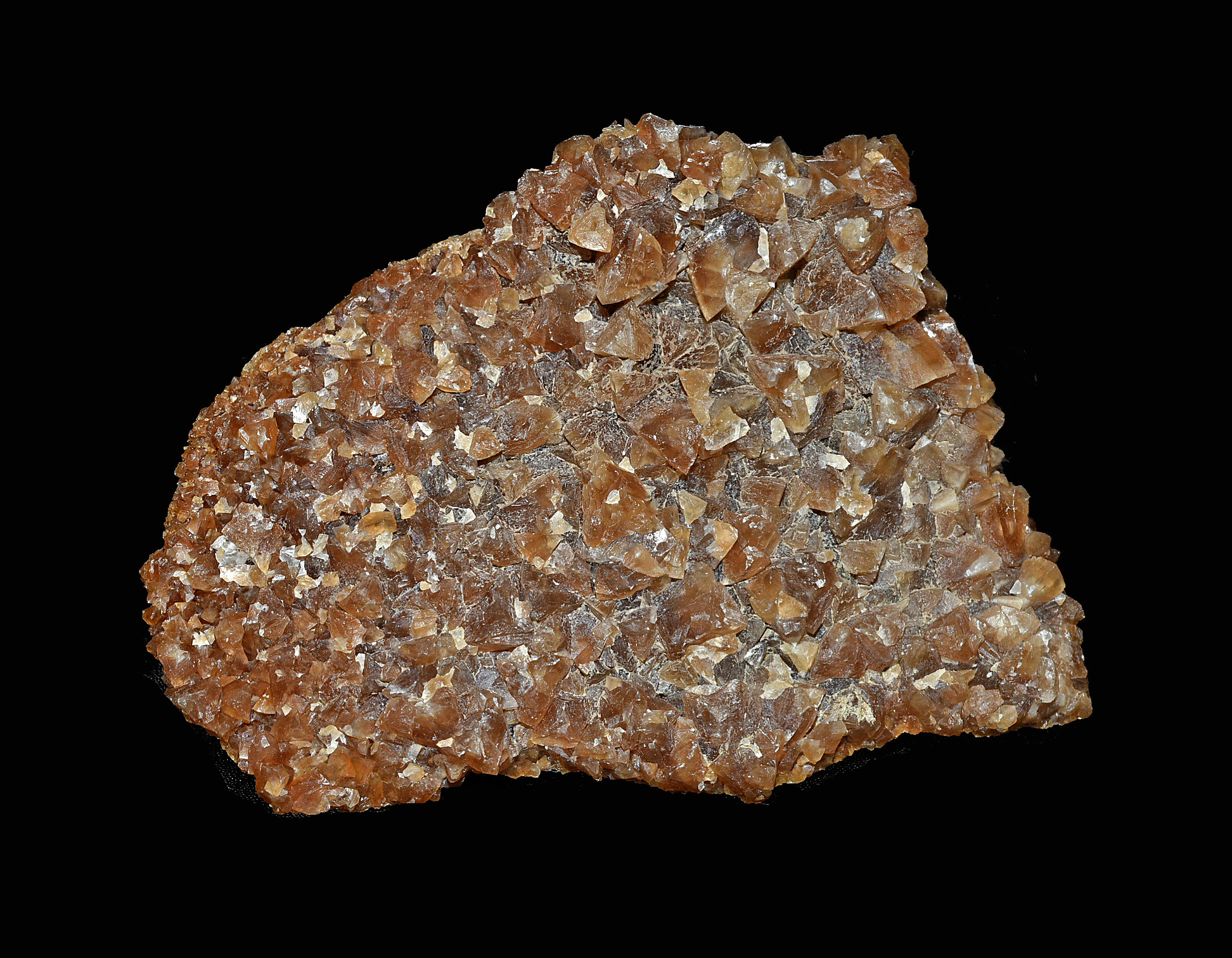


Book Cliffs area, Grand Junction, Mesa County, Colorado, USA