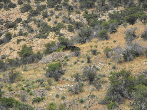
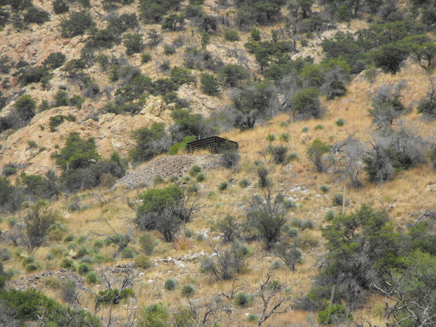
State of Texas Mine, Montezuma Canyon, Cochise County, Arizona, USAi
| Regional Level Types | |
|---|---|
| State of Texas Mine | Mine |
| Montezuma Canyon | Canyon |
| Cochise County | County |
| Arizona | State |
| USA | Country |
This page is currently not sponsored. Click here to sponsor this page.


Latitude & Longitude (WGS84):
31° 21' 2'' North , 110° 16' 19'' West
Latitude & Longitude (decimal):
Type:
Köppen climate type:
Nearest Settlements:
| Place | Population | Distance |
|---|---|---|
| Miracle Valley | 644 (2011) | 11.7km |
| Sierra Vista Southeast | 14,797 (2011) | 12.6km |
| Palominas | 212 (2011) | 15.0km |
| Sierra Vista | 43,355 (2017) | 22.9km |
| Naco | 1,046 (2011) | 30.8km |
Nearest Clubs:
Local clubs are the best way to get access to collecting localities
Local clubs are the best way to get access to collecting localities
| Club | Location | Distance |
|---|---|---|
| Huachuca Mineral and Gem Club | Sierra Vista, Arizona | 23km |
Mindat Locality ID:
32764
Long-form identifier:
mindat:1:2:32764:5
GUID (UUID V4):
e6f085d2-a252-4899-9acd-baf7e20aee5b
A former small underground Zn-Pb-Ag-Cu-Au mine located on 1 patented and 6 unpatented claims in the SW ¼ sec. 12 & NW ¼ sec. 13, T.24S., R.20E., on the north side Montezuma Canyon, at approximately 5,700 feet of altitude, near the SE end of the range. Produced 1897-1947. NOTE: This mine is located in a wilderness area and collecting is strictly prohibited. Discovered by August Baron about 1889 and was surveyed for patent in 1898; a few years later Baron's claim and 32 other claims were acquired by the Mitchell Development Co., of Ishpeming, Michigan. Subsequently held by Miss Grace Sparkes (circa 1951).
Mineralization is irregular replacement orebodies of sulfides with lime silicates in folded and faulted impure Pennsylvanian-Permian Naco Group limestone and Escabrosa Limestone along the contact with Jurassic Huachuca Quartz Monzonite. The contact is inclined approximately 30N.
The ore replaced favorable portions of the impure limestone with the arch of a northward-plunging low anticline. The roof in the southern part of the stope shows a fault dipping 20º southward immediately above the ore. Two fissure zones, about 25 feet apart, striking N.80ºW. and almost vertical, are associated with the best-developed mineralization.
From top to bottom, this side of the canyon shows the following sequence of rocks: (1) Granite, classified as quartz monzonite, forming large mass of the ridge; (2) marble, approximately 60 feet thick; (3) impure, dark gray limestone, approximately 40 feet thick; (4) porphyry sill, 5 to 20 feet thick; and (5) reddish-brown shale, sandstone, and quartzite to the bed of the canyon.
The marble and limestone resemble portions of the Carboniferous Escabrosa and Naco formations, and the underlying shale-sandstone series is probably Cretaceous. Low-angle and steep reverse faulting has thrust the older rocks over the younger rocks (Cretaceous sandstone). The porphyry sill was intruded along a low-angle fault, and presumably the larger masses of quartz monzonite came in along zones of reverse and shear faulting. In places renewed fault movement occurred along the contacts. For example, a fault zone dipping 80º northward and locally marked by copper stain, separates the marble from the intrusive mass north of the mine. The marble and limestone south of this fault form a belt approximately 350 feet wide and several hundred feet long from east to west. Their beds in general dip 15º to 50º northward, but in places they have been deformed by flexures and faults.
Workings in 1903 included 3 tunnels and a shaft about 250 feet deep, and a shallower shaft, plus about 250 feet of drifts and an irregular stope about 80 feet in maximum length and bredth by 5 to 15 feet high. This mine was reportedly worked by Spaniards originally and again in the late 1880's. Some 1,791 tons of ore were produced in 1943-1947. This yielded 330,000 pounds of Zn and contained 1.0% to 6.65% Pb, and 0.2 to 1.12% Cu, together with 2.75 to 11.0 oz Ag and less than 0.1 oz. Au/T.
NOTE: This mine is now within the boundaries of a wilderness area. Public access is unrestricted but collecting is strictly prohibited. If caught, any collected materials will be confiscated and violators risk charges.
Select Mineral List Type
Standard Detailed Gallery Strunz Chemical ElementsDetailed Mineral List:
| ⓘ Calcite Formula: CaCO3 |
| ⓘ Chalcopyrite Formula: CuFeS2 |
| ⓘ Galena Formula: PbS References: |
| ⓘ 'Garnet Group' Formula: X3Z2(SiO4)3 |
| ⓘ Hematite Formula: Fe2O3 References: Rolf LuetckeIdentified by Rolf Luetcke: Visual Identification |
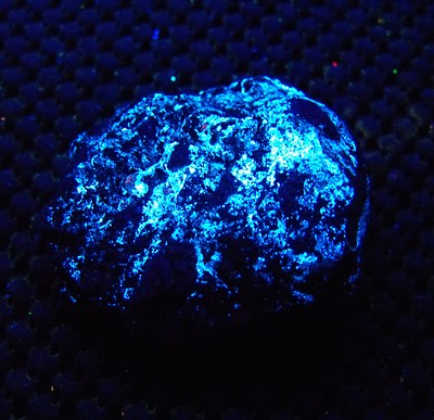
| ⓘ Hydrozincite Formula: Zn5(CO3)2(OH)6 References: Rolf LuetckeIdentified by Rolf Luetcke: Visual (Fluorescence) |
| ⓘ Pyrite Formula: FeS2 |
| ⓘ Sphalerite Formula: ZnS References: |
| ⓘ Willemite Formula: Zn2SiO4 |
Gallery:

List of minerals arranged by Strunz 10th Edition classification
| Group 2 - Sulphides and Sulfosalts | |||
|---|---|---|---|
| ⓘ | Sphalerite | 2.CB.05a | ZnS |
| ⓘ | Chalcopyrite | 2.CB.10a | CuFeS2 |
| ⓘ | Galena | 2.CD.10 | PbS |
| ⓘ | Pyrite | 2.EB.05a | FeS2 |
| Group 4 - Oxides and Hydroxides | |||
| ⓘ | Hematite | 4.CB.05 | Fe2O3 |
| Group 5 - Nitrates and Carbonates | |||
| ⓘ | Calcite | 5.AB.05 | CaCO3 |
| ⓘ | Hydrozincite | 5.BA.15 | Zn5(CO3)2(OH)6 |
| Group 9 - Silicates | |||
| ⓘ | Willemite | 9.AA.05 | Zn2SiO4 |
| Unclassified | |||
| ⓘ | 'Garnet Group' | - | X3Z2(SiO4)3 |
List of minerals for each chemical element
| H | Hydrogen | |
|---|---|---|
| H | ⓘ Hydrozincite | Zn5(CO3)2(OH)6 |
| C | Carbon | |
| C | ⓘ Calcite | CaCO3 |
| C | ⓘ Hydrozincite | Zn5(CO3)2(OH)6 |
| O | Oxygen | |
| O | ⓘ Calcite | CaCO3 |
| O | ⓘ Hematite | Fe2O3 |
| O | ⓘ Hydrozincite | Zn5(CO3)2(OH)6 |
| O | ⓘ Willemite | Zn2SiO4 |
| O | ⓘ Garnet Group | X3Z2(SiO4)3 |
| Si | Silicon | |
| Si | ⓘ Willemite | Zn2SiO4 |
| Si | ⓘ Garnet Group | X3Z2(SiO4)3 |
| S | Sulfur | |
| S | ⓘ Chalcopyrite | CuFeS2 |
| S | ⓘ Galena | PbS |
| S | ⓘ Pyrite | FeS2 |
| S | ⓘ Sphalerite | ZnS |
| Ca | Calcium | |
| Ca | ⓘ Calcite | CaCO3 |
| Fe | Iron | |
| Fe | ⓘ Chalcopyrite | CuFeS2 |
| Fe | ⓘ Hematite | Fe2O3 |
| Fe | ⓘ Pyrite | FeS2 |
| Cu | Copper | |
| Cu | ⓘ Chalcopyrite | CuFeS2 |
| Zn | Zinc | |
| Zn | ⓘ Hydrozincite | Zn5(CO3)2(OH)6 |
| Zn | ⓘ Sphalerite | ZnS |
| Zn | ⓘ Willemite | Zn2SiO4 |
| Pb | Lead | |
| Pb | ⓘ Galena | PbS |
Other Databases
| Link to USGS MRDS: | 10048121 |
|---|
Other Regions, Features and Areas containing this locality
Mexico
- Sierra Madre OccidentalMountain Range
North America
- Sonoran DesertDesert
North America PlateTectonic Plate
USA
- Arizona
- Cochise County
- Hartford Mining DistrictMining District
- Huachuca MountainsMountain Range
- Cochise County
This page contains all mineral locality references listed on mindat.org. This does not claim to be a complete list. If you know of more minerals from this site, please register so you can add to our database. This locality information is for reference purposes only. You should never attempt to
visit any sites listed in mindat.org without first ensuring that you have the permission of the land and/or mineral rights holders
for access and that you are aware of all safety precautions necessary.
References


State of Texas Mine, Montezuma Canyon, Cochise County, Arizona, USA