Home PageAbout MindatThe Mindat ManualHistory of MindatCopyright StatusWho We AreContact UsAdvertise on Mindat
Donate to MindatCorporate SponsorshipSponsor a PageSponsored PagesMindat AdvertisersAdvertise on Mindat
Learning CenterWhat is a mineral?The most common minerals on earthInformation for EducatorsMindat ArticlesThe ElementsThe Rock H. Currier Digital LibraryGeologic Time
Minerals by PropertiesMinerals by ChemistryAdvanced Locality SearchRandom MineralRandom LocalitySearch by minIDLocalities Near MeSearch ArticlesSearch GlossaryMore Search Options
The Mindat ManualAdd a New PhotoRate PhotosLocality Edit ReportCoordinate Completion ReportAdd Glossary Item
Mining CompaniesStatisticsUsersMineral MuseumsClubs & OrganizationsMineral Shows & EventsThe Mindat DirectoryDevice SettingsThe Mineral Quiz
Photo SearchPhoto GalleriesSearch by ColorNew Photos TodayNew Photos YesterdayMembers' Photo GalleriesPast Photo of the Day GalleryPhotography
╳Discussions
💬 Home🔎 Search📅 LatestGroups
EducationOpen discussion area.Fakes & FraudsOpen discussion area.Field CollectingOpen discussion area.FossilsOpen discussion area.Gems and GemologyOpen discussion area.GeneralOpen discussion area.How to ContributeOpen discussion area.Identity HelpOpen discussion area.Improving Mindat.orgOpen discussion area.LocalitiesOpen discussion area.Lost and Stolen SpecimensOpen discussion area.MarketplaceOpen discussion area.MeteoritesOpen discussion area.Mindat ProductsOpen discussion area.Mineral ExchangesOpen discussion area.Mineral PhotographyOpen discussion area.Mineral ShowsOpen discussion area.Mineralogical ClassificationOpen discussion area.Mineralogy CourseOpen discussion area.MineralsOpen discussion area.Minerals and MuseumsOpen discussion area.PhotosOpen discussion area.Techniques for CollectorsOpen discussion area.The Rock H. Currier Digital LibraryOpen discussion area.UV MineralsOpen discussion area.Recent Images in Discussions


Identity HelpDrop stone in varved clay

8th Sep 2017 21:51 UTCJohn Collins

1) Do any of you know what the approximate age of this glacial deposition might be?
2) Have I interpreted what I see correctly?
Thanks,
John
8th Sep 2017 22:15 UTCRichard Gunter Expert
You appear to have a sample of the well-known Huronian Age tillite horizon. It is equivalent to much of the Precambrian strata in the Cobalt area and is part of the Southern Geological Province. Given the dynamics of supra-glacial lakes and the very fine-grained size of the glacial sediments I would suggest that it was the drop stone that moved into the sediment and not the sediment moving. Do you have the sample in the orientation you found it or is it upside down? The compression of the sediments would make more sense if they were under the drop stone.
8th Sep 2017 23:15 UTCEd Clopton 🌟 Expert
I wait with Richard to find out whether the specimen is posed right side up. I can see it either way, but its appearance would be easier to explain other side up.

9th Sep 2017 00:35 UTCWoody Thompson Expert
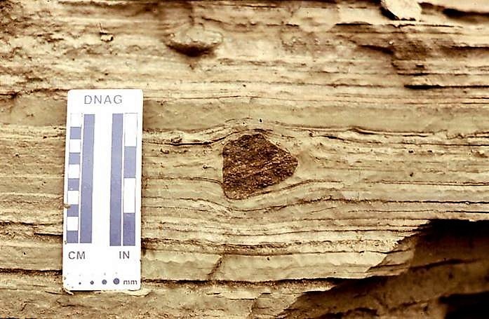
If this material were lithified and detached, like the Ontario rock, it might be hard to tell "which way was up"! If that sample preserves graded beds, which often are finer upward, that could help. Nice rock in any case!!
9th Sep 2017 00:58 UTCJohn Collins
Thanks for your reply.
You can see the actual collecting spot on Google Earth. The specimen was loose at the bottom of the ditch and I don't remember the orientation of the tillite bedding but it is clear that the bedding direction was horizontal as photographed. I think you are correct in thinking that the rock was photographed upside down When looking at the inverted photo, just above and to the right of the granite there looks to be a later and smaller drop stone slightly lighter in coloring from the clay. If the stream direction was from left to right in the inverted photo, then the suspended clay stream lines would match the flow pattern that we see (I think).
When I look at the back of my specimen, the layering is quite regular and is parallel to the undisturbed bedding direction on the pebble side.
Thanks for the historical information about this formation.
Regards,
John
9th Sep 2017 01:04 UTCJohn Collins
I do think my specimen was photographed upside down. Oh well.
Regards,
John
9th Sep 2017 01:26 UTCWoody Thompson Expert
That may well be the case (i.e. the rock may be posed upside down). It looks like there's more sediment disturbance just above and to the right of the granite pebble, as seen in the photo.
If this was a lake bottom environment, currents might have resulted from sediment-laden gravity-driven flows across the lake floor, like in front of a delta. However, I don't see evidence of currents in the photo, and it could have been quiet water as Richard proposed.
It's been many years since I saw the Ontario tillites. This kind of stuff is what I do for a living (mapping and researching New England glacial environments), so great fun!

9th Sep 2017 02:12 UTCPaul Brandes 🌟 Manager
Your specimen was indeed photographed upside down by looking at the bomb-sag structure that is to the top and left of the quartzite (not granite) in the sediments. Look at Woody's sample and you see the same structure on the lower left corner of the dropstone. I do agree with Richard in that this is part of a typical Huronian tillite deposit.

9th Sep 2017 16:14 UTCSteve Hardinger 🌟 Expert

9th Sep 2017 17:09 UTCRob Woodside 🌟 Manager
9th Sep 2017 17:29 UTCDonald B Peck Expert
9th Sep 2017 22:44 UTCJohn Collins
I already have: ID# 4AQ-5TE
regards,
John
9th Sep 2017 22:44 UTCJohn Collins
Thanks for your informative replies. I have encorporated your details into the description of the mindat mineral # 4AQ-5TE.
Check the scene via Google Earth at 46° 26' 55" N, 83° 44' 01" W.
Regards,
John
10th Sep 2017 02:37 UTCWoody Thompson Expert
I'll need to re-scan my 35 mm slide to get better resolution. The photo upload process doesn't accept the low-res version I posted above. Had a long day of field work, so will do this tomorrow.
10th Sep 2017 13:34 UTCJohn Collins
Thanks for your informative replies. I have encorporated your details into the description of the mindat mineral # 4AQ-5TE.
Check the scene via Google Earth at 46° 26' 55" N, 83° 44' 01" W.
Paul, sorry about the earlier typo.
Regards,
John
10th Sep 2017 15:51 UTCWoody Thompson Expert
I uploaded a higher-res version of the Maine glacial dropstone, so it can be compared with your Ontario tillite specimen:
https://www.mindat.org/5KC-NNQ
Cheers,
Woody
10th Sep 2017 16:05 UTCRob Woodside 🌟 Manager
10th Sep 2017 16:49 UTCJohn Collins
John
10th Sep 2017 21:56 UTCPaul Brandes 🌟 Manager
-------------------------------------------------------
> Paul, sorry about the earlier typo.
No worries; I've been called much worse in my career.... ;-)
Thanks John and Woody for your contributions.
11th Sep 2017 00:23 UTCHolger Hartmaier 🌟


Mindat.org is an outreach project of the Hudson Institute of Mineralogy, a 501(c)(3) not-for-profit organization.
Copyright © mindat.org and the Hudson Institute of Mineralogy 1993-2024, except where stated. Most political location boundaries are © OpenStreetMap contributors. Mindat.org relies on the contributions of thousands of members and supporters. Founded in 2000 by Jolyon Ralph.
Privacy Policy - Terms & Conditions - Contact Us / DMCA issues - Report a bug/vulnerability Current server date and time: April 20, 2024 00:57:10