Home PageAbout MindatThe Mindat ManualHistory of MindatCopyright StatusWho We AreContact UsAdvertise on Mindat
Donate to MindatCorporate SponsorshipSponsor a PageSponsored PagesMindat AdvertisersAdvertise on Mindat
Learning CenterWhat is a mineral?The most common minerals on earthInformation for EducatorsMindat ArticlesThe ElementsThe Rock H. Currier Digital LibraryGeologic Time
Minerals by PropertiesMinerals by ChemistryAdvanced Locality SearchRandom MineralRandom LocalitySearch by minIDLocalities Near MeSearch ArticlesSearch GlossaryMore Search Options
The Mindat ManualAdd a New PhotoRate PhotosLocality Edit ReportCoordinate Completion ReportAdd Glossary Item
Mining CompaniesStatisticsUsersMineral MuseumsClubs & OrganizationsMineral Shows & EventsThe Mindat DirectoryDevice SettingsThe Mineral Quiz
Photo SearchPhoto GalleriesSearch by ColorNew Photos TodayNew Photos YesterdayMembers' Photo GalleriesPast Photo of the Day GalleryPhotography
╳Discussions
💬 Home🔎 Search📅 LatestGroups
EducationOpen discussion area.Fakes & FraudsOpen discussion area.Field CollectingOpen discussion area.FossilsOpen discussion area.Gems and GemologyOpen discussion area.GeneralOpen discussion area.How to ContributeOpen discussion area.Identity HelpOpen discussion area.Improving Mindat.orgOpen discussion area.LocalitiesOpen discussion area.Lost and Stolen SpecimensOpen discussion area.MarketplaceOpen discussion area.MeteoritesOpen discussion area.Mindat ProductsOpen discussion area.Mineral ExchangesOpen discussion area.Mineral PhotographyOpen discussion area.Mineral ShowsOpen discussion area.Mineralogical ClassificationOpen discussion area.Mineralogy CourseOpen discussion area.MineralsOpen discussion area.Minerals and MuseumsOpen discussion area.PhotosOpen discussion area.Techniques for CollectorsOpen discussion area.The Rock H. Currier Digital LibraryOpen discussion area.UV MineralsOpen discussion area.Recent Images in Discussions


GeneralPossible injection of fluidized sand into vesicles in basalt.

11th Jun 2017 15:36 UTCLarry Maltby Expert
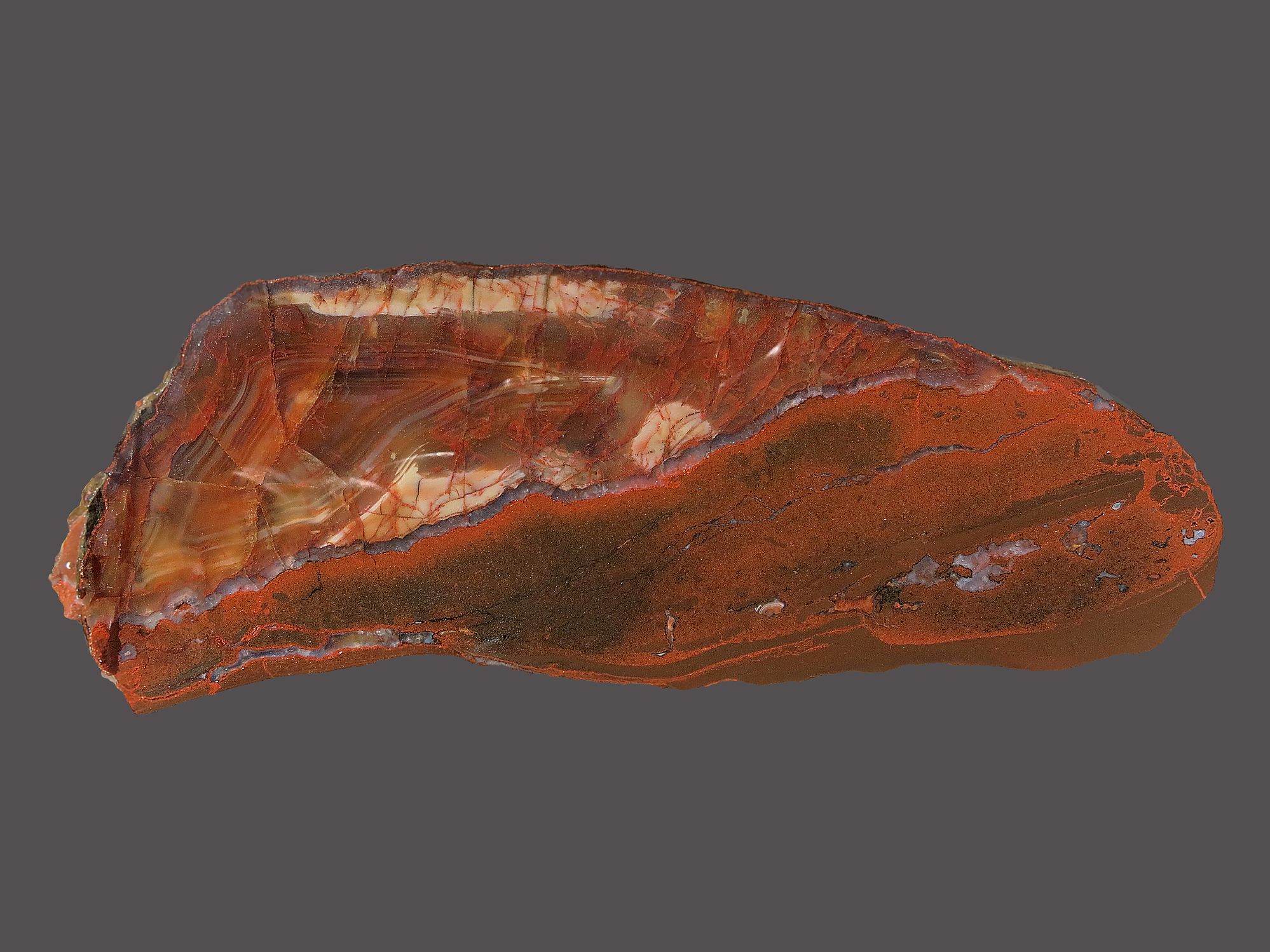
Figure 1.
I have shown the entire abstract below and I have highlighted the words that may apply to this specimen. I have at least 20 more specimens like this showing various features that may help with a solution. Much more to follow.
Sequential opening and filling of cavities forming vesicles, amygdales and giant amethyst geodes in lavas from the southern Paraná volcanic province, Brazil and Uruguay
L, A. Hartmann, et-all, Journal: International Geology Review, 2012, Volume 54, Number 1, Page 1
“The opening and filling of cavities in rocks are the major processes related to the generation and sealing of porosity in ore deposits. This study documents three stages of opening and filling of vesicles and geodes in the basalts and rhyodacites of the southern Paraná volcanic province. Each step detailed here is actually part of a sequence of minor hydrothermal events. First, lava degassing at high temperature (1150°C) formed small (<4 cm) vesicles in the crusts of flow units. In sequence, these vesicles were partly to fully filled at low temperature (30–150°C) by hydrothermal minerals, particularly clays and zeolites; this process also sealed the porosity of the lava. Second, the injection of fluidized sand generated new cavities, which were partly filled with sand; the newly formed porosity was sealed by the low-temperature fluid. Third, intense alteration of the basalt or rhyodacite core into a claystone favoured the opening of small to giant protogeodes (0.1 mm to 4 m) by dissolution; cooling of the fluid led to the precipitation of hydrothermal minerals, particularly the spectacular amethyst, calcite, and gypsum-bearing geodes.”
During my research on this subject, I came across references to clastic dykes that are filled with sediments and intruded into other formations. Some of the dykes are filled with basaltic sand. All of the specimens that I will show here were found adjacent to a vertical dyke in the host basalt. Here is a reference: https://en.wikipedia.org/wiki/Clastic_dike
Please let me know what you think!

11th Jun 2017 23:32 UTCRalph S Bottrill 🌟 Manager
12th Jun 2017 09:25 UTCJason Bennett
In line with Ralph's request for further photos, in-situ textural evidence would be really useful to help distinguish each hypothesis here...are the agates collected in-situ or weathered out somewhere?
12th Jun 2017 15:17 UTCLarry Maltby Expert

This geological detail has not been professionally recorded in the Geology of Michigan. I need help to better interpret what we see and I would like to correctly describe these specimens in the Mindat data base.
Unfortunately I do not have a good photo of the vein in-situ. Like most field collectors we get so involved trying to read the terrain looking for a good spot to prospect that we forget we have a camera. Also, I did not realize the significance of these specimens at the time. I do think that I can supply enough photos to define the geology. The issue will likely be, is the material in the vein and in the vesicles sediment or a basaltic intrusion?
Jason, Thanks for your comments also. We look forward to your views on this.
Here are photos of the uncovering of the agate shown above. I was right in line with the vein but the vein was removed during excavation.
Figure 2.

This is the top of the agate rotated 180 degrees. The jagged edge has been cut away for the photos.
This is the top of the agate rotated 180 degrees. The jagged edge has been cut away for the photos.

This is the top of the agate rotated 180 degrees. The jagged edge has been cut away for the photos.
12th Jun 2017 17:12 UTCLarry Maltby Expert

Figure 3.
This is the exterior of an agate attached to an intrusive vein.
This is the exterior of an agate attached to an intrusive vein.

This is the exterior of an agate attached to an intrusive vein.

12th Jun 2017 18:27 UTCGregg Little 🌟
It appears the system was still very active after the "injection" as there is further agate(?) filling the void space inside the "injected" area. Also note that the agate part and the "injected" part could represent fault reactivation with the fill representing stages of fracture opening.
In the oil exploration field we see similar evidence where gravity-fill is not the sole operator. There are structures like sand dykes and even sand volcanoes. In these cases the sand bed is water saturated and confined above and below causing it to pressure up with compaction (settling, increase overburden, etc). Any fracturing or faulting allows a sudden release of water and sediment into adjacent beds or units either above or below.
13th Jun 2017 15:19 UTCLarry Maltby Expert
With your and Ralph’s comments I think that we will be able to come up with a reasonable explanation for these specimens. I have attached below a photo of the contact between the intrusive material and the host basalt. As you can see the contrast is significant. I plan to lap the specimen to 1200 grit and take micro-photos of each texture. Photos to follow.
Your comment on how sediment can be fluidized and pressurized probably explains how the vesicles near the vein were infilled. At the time that we were collecting we did not know about this and could have easily missed a feeder vein. Vesicles three or four feet away from the vein were completely filled with agate only. (8.5 x 5.0 x 8.0 cm)
Figure 4.
15th Jun 2017 16:15 UTCLarry Maltby Expert

The best way to see this is to enlarge the bottom portion of the specimen and note the texture and flow lines. There is even some indication of stratification. The porosity is likely the result of liquefaction that aided the transportation of the materials through the vein system. Some of the porosity was later filled with the deposition of quartz.
Figure 5.
17th Jun 2017 15:27 UTCLarry Maltby Expert

Here is a specimen that shows what I now think is a confirmed clastic vein passing right through a filled vesicle in basalt. It appears that when the basalt fractured the crack passed through an empty vesicle offsetting the two halves by about 0.5 cm. The view is of the slightly concave bottom with the left and right ends broken off. The face view of both ends shows the domed shape typical of a gas bubble in a viscus lava. As you can see the material in the vein looks like sand. (9.0 x 9.5 x 3.5 cm) The vein width is about 2.0 cm.
Figure 6.
The Lake Shore Traps are interbedded with conglomerate, sandstone and mudstone. These formations found on the beach of Lake Superior at one time covered the traps but were eroded away by glacial action on the inland ridges. It looks like a source of sand was available to fill the fracture and the color is similar.
Figure 7.
Jason,
I forgot to answer your question. Yes, all of the specimens were collected in-situ.
21st Jun 2017 16:51 UTCLarry Maltby Expert
http://www.swanson-hysell.org/2012/01/20/featured-field-photo-bifurcating-clastic-dike/
23rd Jun 2017 23:35 UTCRalph S Bottrill 🌟 Manager

24th Jun 2017 04:20 UTCPaul Brandes 🌟 Manager
Very interesting to say the least, Larry! I have seen the clastic dykes of the Osler Group many years ago and we as a group marveled at how you could get a clastic (sediment) dyke in an igneous rock. The article you provided is one of two ways we postulated as to how you could possibly get this occurrence. One was indeed lava flowing over a wet sediment and boiling the water to steam. Once the steam pressure is high enough (think phreato-magmatic eruption), the slightly cooled lava cracks and sediments infill the fissure. The second way we thought of is a situation similar to sand blows you sometimes see during strong earthquakes whereby saturated sediments due to liquefaction are injected into any crack or fissure it can find in the already cooled basalt, then lithify over time.
As you stated earlier Larry, this is one of the many pieces of Keweenawan geology that has yet to be fully understood. To me, this begs for a research project to be initiated.
24th Jun 2017 06:19 UTCGregg Little 🌟
As Ralph says it is difficult doing geology at a distance but I have some overall impressions to share. There appears, as seen in your June 15th post, to be at least two stages of dyke injection defined by the two areas of presence and absence of vesicles. The initial injection was the vesicle bearing sediment evident from formation against the fracture walls and its occurrence as semi-consolidated clasts floating in the vesicle free(?) second stage injection. The angular shape of the floating vesicle-riddled clasts reminds me of shale rip-up clasts in the sedimentary environment. Part of the basalt wall rock also appears to be ripped-up by the second stage injection.
I would also seem plausible that the first injection was more gaseous; higher temperature and greater pressure release (hence vesicles) followed by the second injection being slower(?) and probably lower pressure resulting in little or no vesicles and more of a laminar flow texture. Again this is just speculation from a remote perspective.
26th Jun 2017 17:25 UTCLarry Maltby Expert
I do hope to review these specimens with several geologists. I have about 30 specimens of this type. They are all very interesting and I will use this thread to show many more photos during this summer. I have added figure numbers to all of the photos to facilitate discussion.
Gregg,
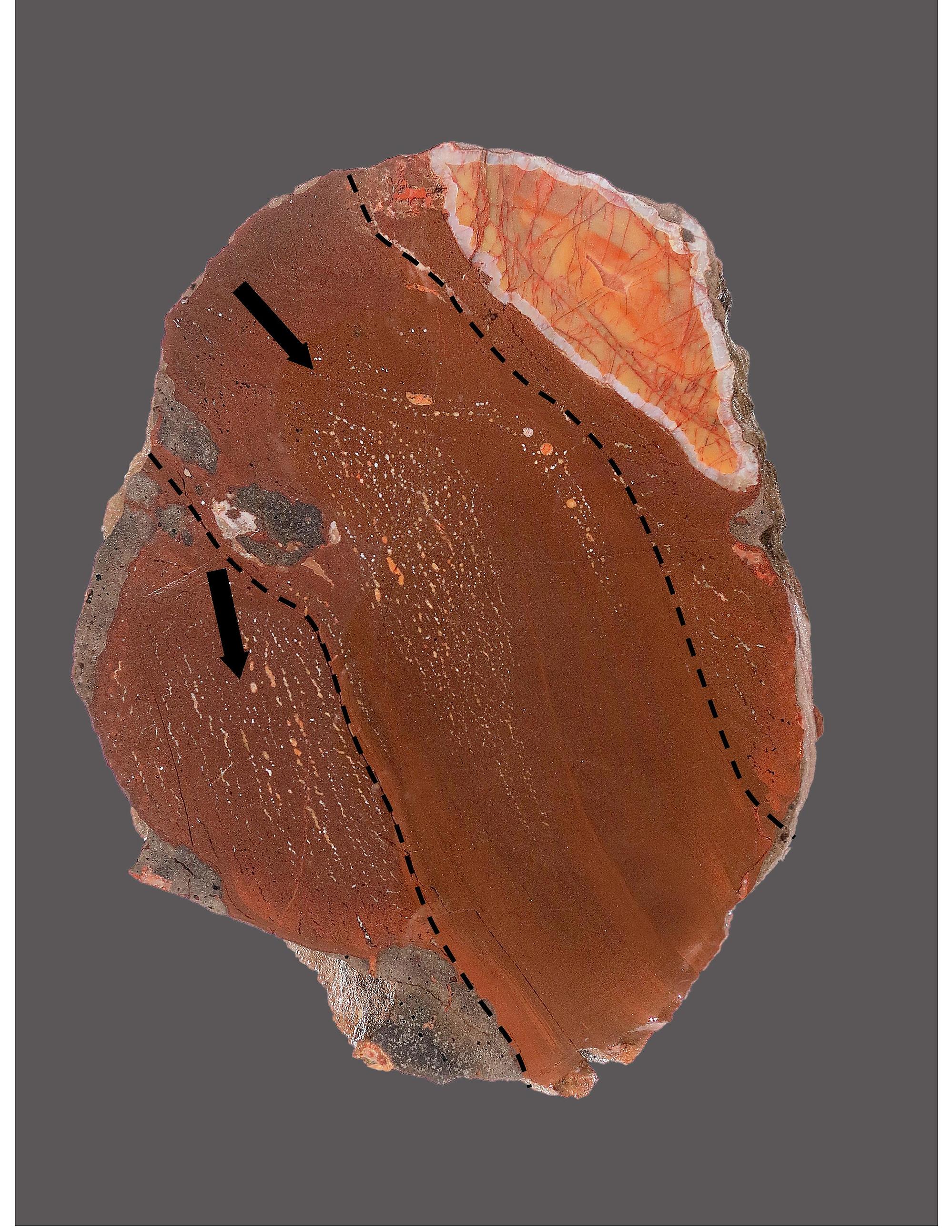
Regarding your comment on figure 5, I see the “flow lines” that I think that you are referring to. I have added the photo below to illustrate some additional information. When I look at the two halves of the specimen, it appears that the fracture (4.5 cm wide) destroyed a preexisting vesicle. The dotted lines depicting the width of the vein can be seen as flow lines in figure 5. I also added my guess as to the direction of flow. (Particles of the host basalt were pulled into the vein.) The space in which the agate formed may have been preserved by compressed air/gas during the intrusion of the sediment.
Figure 8.
Paul,
I agree that more work is needed to define he mineralogy and the geology of the Traps. I have a lot of material that I am trying to get into the Mindat data base. I better hurry, I turned 80 years old this spring.

26th Jun 2017 18:46 UTCJolyon Ralph Founder
Larry refers to liquefied sand which, to me at least, suggests it is molten.
The reference cited refers to fluidized sand which to me, at least, suggests sand moving in a fluid-like manner (eg as it does when pouring through an egg-timer)
26th Jun 2017 20:29 UTCLarry Maltby Expert
Point taken. Can I edit the title of the thread without messing it up?
Larry,
26th Jun 2017 21:14 UTCJolyon Ralph Founder
27th Jun 2017 15:26 UTCLarry Maltby Expert
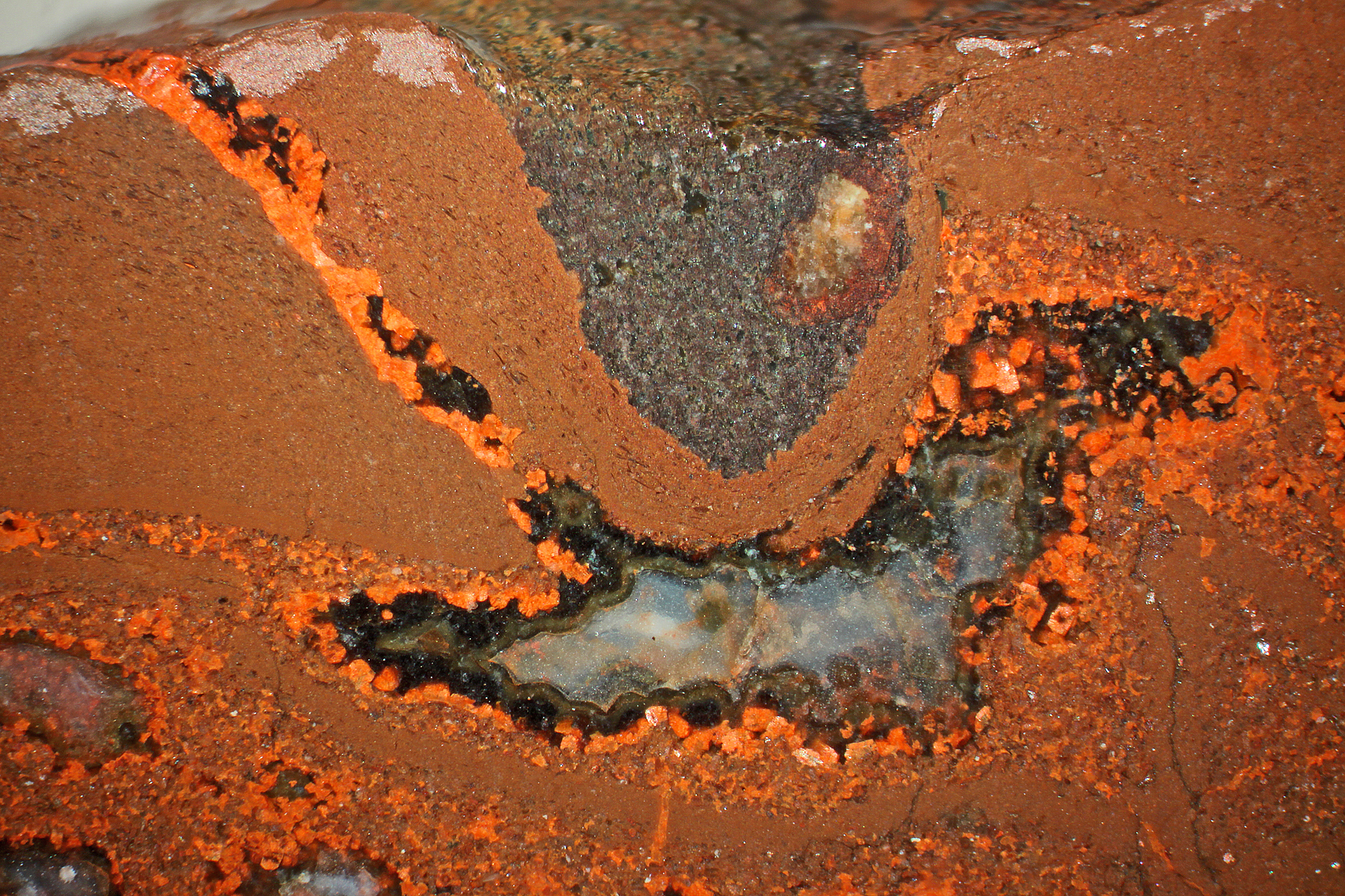
Figure 9.

The cross-cutting vein indicates that the alteration is secondary to the intrusion of the sediments. Laumontite is the most common zeolite found in the Lake Shore Traps ranging in color from white to orange and a dark brownish red.
The cross-cutting vein indicates that the alteration is secondary to the intrusion of the sediments. Laumontite is the most common zeolite found in the Lake Shore Traps ranging in color from white to orange and a dark brownish red.

The cross-cutting vein indicates that the alteration is secondary to the intrusion of the sediments. Laumontite is the most common zeolite found in the Lake Shore Traps ranging in color from white to orange and a dark brownish red.
27th Jun 2017 19:38 UTCGregg Little 🌟
The first fluidized sediment injection might be relatively lower in viscosity due to its gassy character and possibly not have a tendency to mechanically include fragments of nodules and wall rock (basalt). The second fluidized sediment injection could be more viscous and with reactivation of the fracture would provide fragments of the previous sediment intrusion and weaken wall rock material to be included mechanically in the flow. I think the flow lines in the second intrusion indicates a slower rate of intrusion (just an impression). It would also be interesting to analyse these flow lines for composition and hence their formation. A cursory examination, to me, indicates a re-absorption of the included (first) fluid sediment injection fragments as there appears to be dark "tails" streaming from the fragments in the down stream direction, as you have indicated in the photo (figure 8).
Another observation; the gassy sediment fragment with your left-side arrow on it, may not have been transported but by-passed because the fracture wall formed as indicated by your dotted line.
If my ramblings seem a little "out in left field", please remember that fracture geometry is complex (not to mention the material that fills it), we're viewing a 2-D "time-slice" and all this speculation is from a photo.
27th Jun 2017 19:54 UTCGregg Little 🌟
Jolyon; You are such a source of inspiration!
28th Jun 2017 14:06 UTCLarry Maltby Expert
Yes, when you hold the two halves of the large specimen shown in figure 5 and 8, and look at them in 3-D, it becomes apparent that the fracture pattern is very complicated. To really discuss this one we would need to be seated at the table together. The take away from this specimen for me is that the clastic material looks like lithified silt. In my younger days I was an avid trout fisherman and I studied the aquatic insects that trout feed on. This material looks just like the waterlogged silt that I have dredged up from the back waters of trout streams.
The next group of photos that I plan to show will illustrate what appears to be sandstone in veins and vesicles.
29th Jun 2017 19:11 UTCLarry Maltby Expert


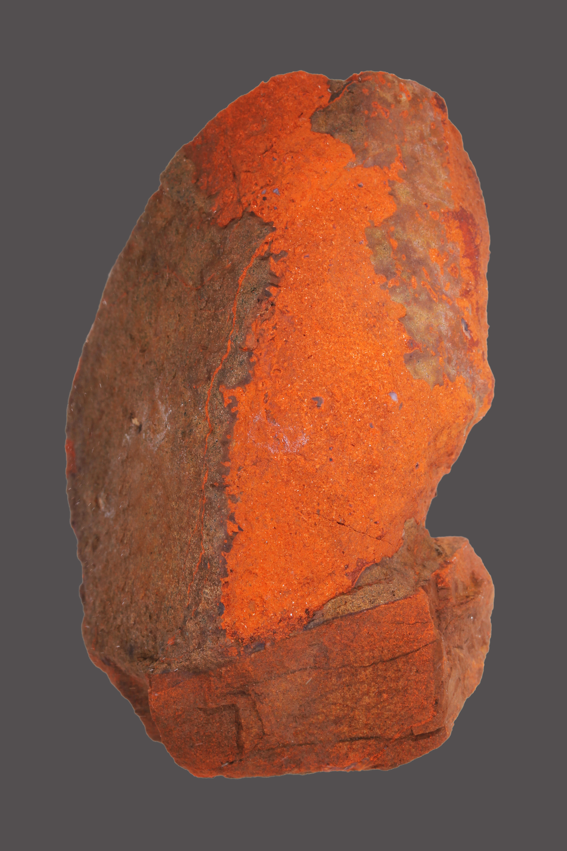
This nodule was found near a vertical clastic dyke and shows evidence of clastic veinlets on the surface. The veinlets contain sandstone that completely filled the vesicle in the basalt.

This is a close-up of the sub-angular grains that make up the sandstone in the veinlets. The veinlet is about 2.5 mm wide.
This nodule was found near a vertical clastic dyke and shows evidence of clastic veinlets on the surface. The veinlets contain sandstone that completely filled the vesicle in the basalt.
This is a close-up of the sub-angular grains that make up the sandstone in the veinlets. The veinlet is about 2.5 mm wide.
Figure 11

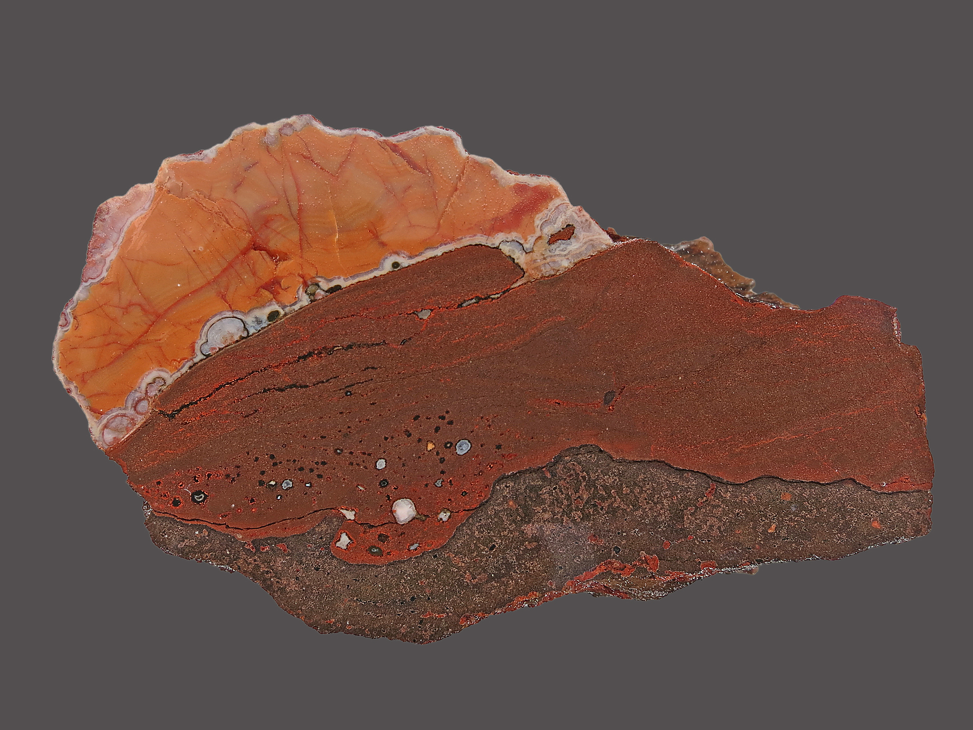
Inside the nodule the sandstone grains are clearly visible and show significant alteration due to silicification including the presence of micro-agates.

This is a close-up of the grains that make up the sandstone inside the nodule. The grains appear to be derived from the brownish red rhyolitic pebbles and cobbles that are very common on Keweenaw beaches and as clasts within the Copper Harbor Conglomerate.

Inside the nodule the sandstone grains are clearly visible and show significant alteration due to silicification including the presence of micro-agates.
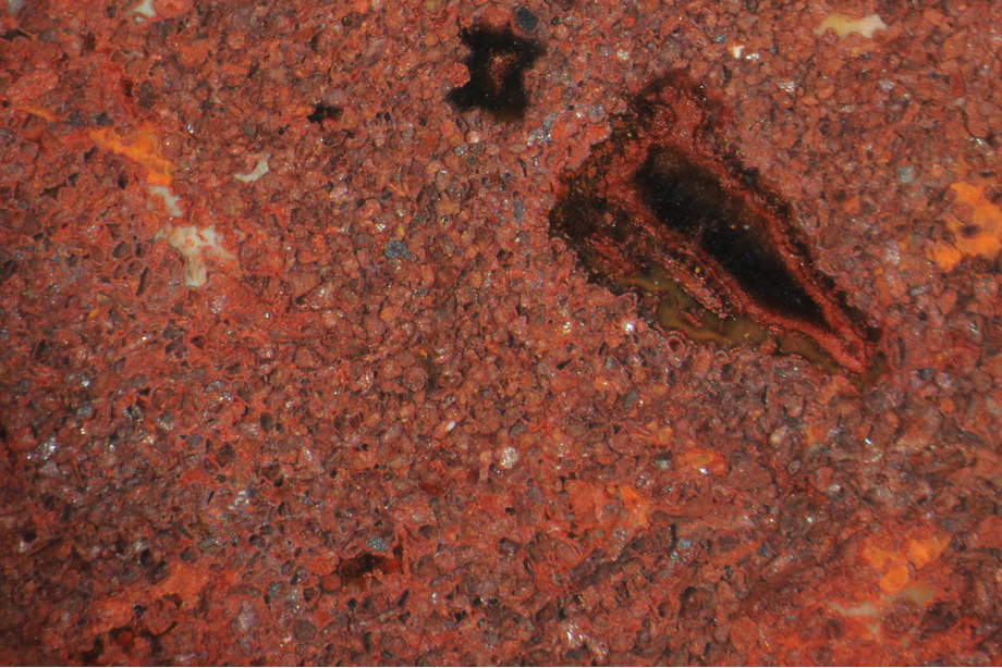
This is a close-up of the grains that make up the sandstone inside the nodule. The grains appear to be derived from the brownish red rhyolitic pebbles and cobbles that are very common on Keweenaw beaches and as clasts within the Copper Harbor Conglomerate.
Inside the nodule the sandstone grains are clearly visible and show significant alteration due to silicification including the presence of micro-agates.
This is a close-up of the grains that make up the sandstone inside the nodule. The grains appear to be derived from the brownish red rhyolitic pebbles and cobbles that are very common on Keweenaw beaches and as clasts within the Copper Harbor Conglomerate.
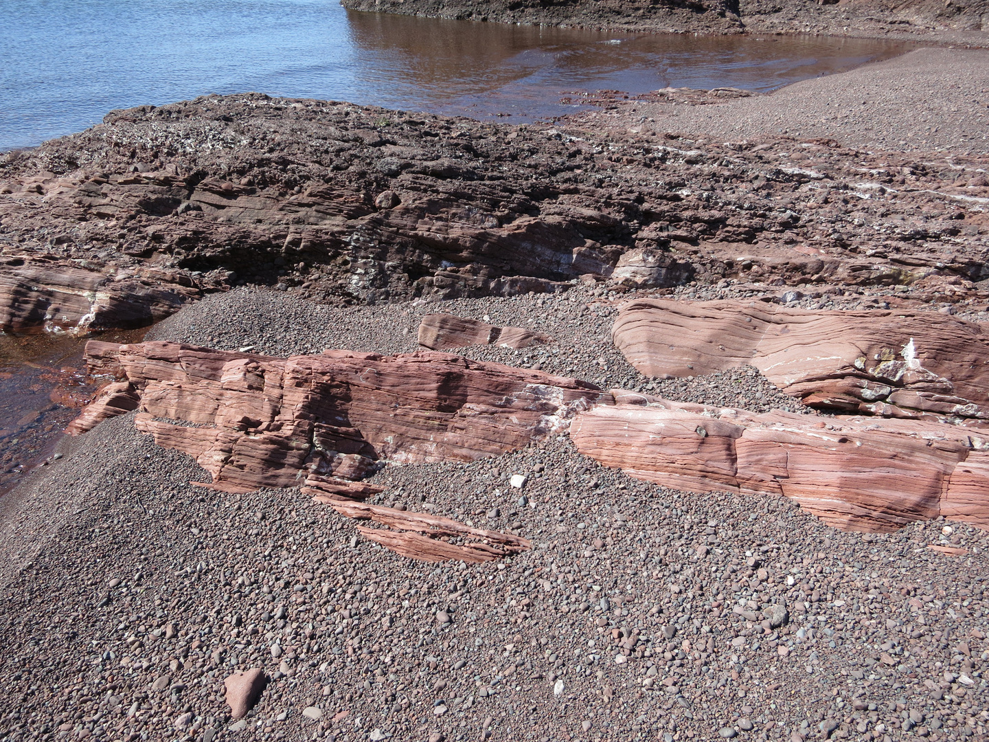
The photo below shows some of the geological environment. The Lake Shore Traps are interbedded in the Copper Harbor Conglomerate. This photo was taken at the water’s edge. You can see the brownish red coloration in the loose gravel and also in pebbles imbedded in the exposed sandstone. The origin of the large clasts of what appears to be felsic amygdaloidal basalt is a mystery. All of the known flows are mafic and dark in color.
Figure 12
29th Jun 2017 23:12 UTCGregg Little 🌟
I am not sure what is felsic, the amygdule mineralization or the ground mass of the basaltic clasts? Also these larger clasts don't seem to have much depth but I suppose that could be the wave erosion but if they are thin (when looking "into" the rock face), they could be the first phase of the sediment injection that coats the walls of the fracture, if the fracture orientation is in the plane of the photo, if you catch my drift? The red colour could be alteration from the warm/hot fluids of the second stage injection.
30th Jun 2017 15:36 UTCLarry Maltby Expert
Here is the definition of felsites/felsic in the Mindat data base. The term felsic is sometimes attached to basalt to refer to silica rich basalt as opposed to (mafic) iron rich basalt.
“Felsites (acid volcanic rocks) tentatively identified as rhyolite, with felsic minerals comprising >20% quartz and alkali feldspar/plagioclase 40-100%” (Ref. Mindat rock data base)
Another name that would fit these large clasts would be “amygdaloidal rhyolite” but I did not find that in the Mindat data base.
By the way this photo was taken on the beach shown in figure 7 above.


Mindat.org is an outreach project of the Hudson Institute of Mineralogy, a 501(c)(3) not-for-profit organization.
Copyright © mindat.org and the Hudson Institute of Mineralogy 1993-2024, except where stated. Most political location boundaries are © OpenStreetMap contributors. Mindat.org relies on the contributions of thousands of members and supporters. Founded in 2000 by Jolyon Ralph.
Privacy Policy - Terms & Conditions - Contact Us / DMCA issues - Report a bug/vulnerability Current server date and time: April 25, 2024 08:46:32