Log InRegister
Quick Links : The Mindat ManualThe Rock H. Currier Digital LibraryMindat Newsletter [Free Download]
Home PageAbout MindatThe Mindat ManualHistory of MindatCopyright StatusWho We AreContact UsAdvertise on Mindat
Donate to MindatCorporate SponsorshipSponsor a PageSponsored PagesMindat AdvertisersAdvertise on Mindat
Learning CenterWhat is a mineral?The most common minerals on earthInformation for EducatorsMindat ArticlesThe ElementsThe Rock H. Currier Digital LibraryGeologic Time
Minerals by PropertiesMinerals by ChemistryAdvanced Locality SearchRandom MineralRandom LocalitySearch by minIDLocalities Near MeSearch ArticlesSearch GlossaryMore Search Options
Search For:
Mineral Name:
Locality Name:
Keyword(s):
 
The Mindat ManualAdd a New PhotoRate PhotosLocality Edit ReportCoordinate Completion ReportAdd Glossary Item
Mining CompaniesStatisticsUsersMineral MuseumsClubs & OrganizationsMineral Shows & EventsThe Mindat DirectoryDevice SettingsThe Mineral Quiz
Photo SearchPhoto GalleriesSearch by ColorNew Photos TodayNew Photos YesterdayMembers' Photo GalleriesPast Photo of the Day GalleryPhotography

Epidote from Graham County, Arizona, USA

USA
 
  • Arizona
    • Graham County
Anthony, J.W., et al (1995), Mineralogy of Arizona, 3rd.ed.: 215
Simons, F.S. (1964), Geology of the Klondyke quadrangle, Graham & Pinal Cos., AZ, USGS PP 461
Galbraith, F.W. & Brennan (1959), Minerals of AZ: 100
        • Aravaipa
          • Cobre Grande Mountain
Simons, F.S. (1964) Geology of the Klondyke Quadrangle Graham and Pinal Counties. USGS Professional Paper 461: 135-136, Plate 1.
MRDS database Dep. ID #10039447, MRDS ID #M050093.
          • Landsman Camp
Wilson, W.E. (1988), The Iron Cap Mine, Min.Rec.: 19(2): 81-87.
MRDS database Dep. ID #10027133, MRDS ID #M002202.
            • Stowe Gulch
Simons, F.S. (1964), Geology of the Klondyke quadrangle, Graham & Pinal Cos., Arizona, USGS PP 461: 137.
        • Jackson Mountain
MRDS database Dep. ID #10039721, MRDS ID #M050716.
        • Klondyke
MRDS database Dep. ID #10039487, MRDS ID #M050155.
        • Mount Turnbull
MRDS database Dep. ID #10027100, MRDS ID #M002045.
        • Santa Teresa Mountains
          • Stanley Mining District
            • Kelly Gulch
MRDS database Dep. D #10027110, MRDS D #M002128.
      • Lone Star Mining District (Safford Mining District; Dos Pobres Mining District)
        • Peterson Wash
Anthony, J.W., et al (1995), Mineralogy of Arizona, 3rd.ed.: 215
Rose, A.W. (1970), Zonal relations of wallrock alteration and sulfide distribution at porphyry copper deposits, Econ.Geol.: 65: 920-936.
        • Sanchez
MRDS database Dep. ID #10026888, MRDS ID #M000791.
DMW collection
Anthony, J.W., et al (1995), Mineralogy of Arizona, 3rd.ed.: 215
Galbraith, F.W. & D.J. Brennan (1959), Minerals of AZ: 100.
Ross, C.P. (1925a), Geology and ore deposits of the Aravaipa and Stanley mining districts, Graham Co., AZ, USGS Bull. 763
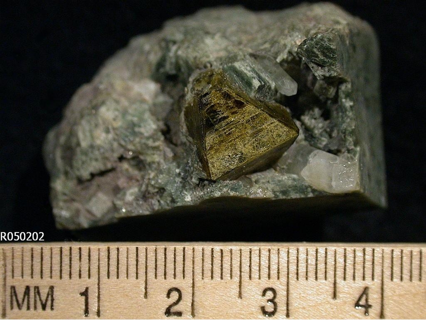
 
Mineral and/or Locality  
Mindat Discussions Facebook Logo Instagram Logo Discord Logo
Mindat.org is an outreach project of the Hudson Institute of Mineralogy, a 501(c)(3) not-for-profit organization.
Copyright © mindat.org and the Hudson Institute of Mineralogy 1993-2024, except where stated. Most political location boundaries are © OpenStreetMap contributors. Mindat.org relies on the contributions of thousands of members and supporters. Founded in 2000 by Jolyon Ralph.
Privacy Policy - Terms & Conditions - Contact Us / DMCA issues - Report a bug/vulnerability Current server date and time: April 19, 2024 18:21:44
Go to top of page