| Locality | Latitude | Longitude | Distance | Bearing |
|---|
| Elsmore Tin Mine (Elsmore Tin lodes), Elsmore, Gough Co., New South Wales, Australia | 29° 48' 38" S | 151° 17' 12" E | 0.0km (0.0 miles) | |
| Champion Hill, Elsmore, Gough Co., New South Wales, Australia | 29° 48' 27" S | 151° 16' 51" E | 0.7km (0.4 miles) | |
| Northern lead (New Years Gift), Elsmore, Gough Co., New South Wales, Australia | 29° 48' 6" S | 151° 16' 46" E | 1.2km (0.7 miles) | |
| Elsmore lead (Elsmore North lead; Penberthys lead), Elsmore, Gough Co., New South Wales, Australia | 29° 48' 43" S | 151° 16' 27" E | 1.2km (0.7 miles) | |
| Braemar sapphire deposit, Elsmore, Gough Co., New South Wales, Australia | 29° 47' 23" S | 151° 17' 35" E | 2.4km (1.5 miles) | |
| Merewethers silver prospect, Elsmore, Gough Co., New South Wales, Australia | 29° 48' 14" S | 151° 15' 33" E | 2.8km (1.7 miles) | |
| Elsmore, Gough Co., New South Wales, Australia | 29° 49' 50" S | 151° 16' 8" E | 2.8km (1.7 miles) | |
| Glassy Bar, Elsmore, Gough Co., New South Wales, Australia | 29° 49' 56" S | 151° 18' 57" E | 3.7km (2.3 miles) | |
| Newstead lode (White Elephant lode), Elsmore, Gough Co., New South Wales, Australia | 29° 49' 45" S | 151° 19' 13" E | 3.8km (2.4 miles) | |
| Stannifer-Bischoff lode, Stannifer, Gough Co., New South Wales, Australia | 29° 51' 56" S | 151° 14' 52" E | 7.2km (4.5 miles) | |
| Stannifer Mine, Stannifer, Gough Co., New South Wales, Australia | 29° 52' 48" S | 151° 13' 49" E | 9.4km (5.9 miles) | |
| Sheep Station Gully and tributaries, Stannifer, Gough Co., New South Wales, Australia | 29° 53' 0" S | 151° 13' 26" E | 10.1km (6.3 miles) | |
| Apple Tree Gully alluvials, Apple Tree Gully, Gough Co., New South Wales, Australia | 29° 43' 41" S | 151° 20' 37" E | 10.7km (6.6 miles) | |
| Stormers Tin Blow, Stannifer, Gough Co., New South Wales, Australia | 29° 53' 20" S | 151° 13' 18" E | 10.7km (6.7 miles) | |
| Apple Tree Gully, Gough Co., New South Wales, Australia | 29° 43' 54" S | 151° 22' 4" E | 11.8km (7.3 miles) | |
| Swan Brook alluvials, Swan Brook, Gough Co., New South Wales, Australia | 29° 44' 18" S | 151° 11' 33" E | 12.1km (7.5 miles) | |
| Woodfords uranium prospect 1, Gilgai, Gough Co., New South Wales, Australia | 29° 50' 34" S | 151° 8' 43" E | 14.1km (8.8 miles) | |
| Horse Gully alluvials, Sapphire, Arrawatta Co., New South Wales, Australia | 29° 41' 48" S | 151° 21' 23" E | 14.3km (8.9 miles) | |
| Butchart lode (Old Buchardt; Butchart Reef; Butchard Reef), Tingha, Hardinge Co., New South Wales, Australia | 29° 55' 35" S | 151° 12' 52" E | 14.6km (9.1 miles) | |
| Frazers Creek, Arrawatta Co., New South Wales, Australia | 29° 40' 58" S | 151° 19' 30" E | 14.7km (9.1 miles) | |
| Sapphire, Arrawatta Co., New South Wales, Australia | 29° 40' 54" S | 151° 20' 3" E | 15.1km (9.4 miles) | |
| Inverell, Gough Co., New South Wales, Australia | 29° 46' 29" S | 151° 7' 59" E | 15.3km (9.5 miles) | |
| The Oaks Lead, Gilgai, Gough Co., New South Wales, Australia | 29° 53' 29" S | 151° 8' 57" E | 16.0km (9.9 miles) | |
| Paradise Creek alluvials, Paradise Creek, Gough Co., New South Wales, Australia | 29° 52' 41" S | 151° 26' 3" E | 16.1km (10.0 miles) | |
| Royal George Mine, Tingha, Hardinge Co., New South Wales, Australia | 29° 56' 49" S | 151° 13' 47" E | 16.1km (10.0 miles) | |
| Gilgai, Gough Co., New South Wales, Australia | 29° 50' 53" S | 151° 7' 4" E | 16.8km (10.5 miles) | |
| Joes and Calthorpes leads, Gilgai, Gough Co., New South Wales, Australia | 29° 52' 37" S | 151° 7' 36" E | 17.1km (10.6 miles) | |
| Tingha, Hardinge Co., New South Wales, Australia | 29° 57' 19" S | 151° 12' 44" E | 17.6km (11.0 miles) | |
| Rooneys lead, Gilgai, Gough Co., New South Wales, Australia | 29° 52' 20" S | 151° 6' 56" E | 17.9km (11.1 miles) | |
| Brissetts lead (Brissets Last Chance lead; Gilgai deep lead), Gilgai, Gough Co., New South Wales, Australia | 29° 51' 32" S | 151° 6' 26" E | 18.1km (11.2 miles) | |
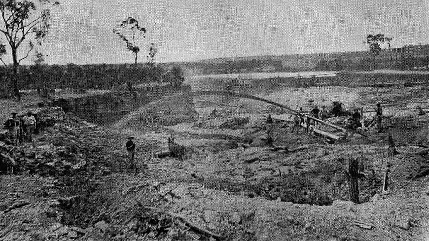


Elsmore Tin Mine, Elsmore, Gough Co., New South Wales, Australia