| Locality | Latitude | Longitude | Distance | Bearing |
|---|
| Wythes and Mooneys Mine, Peak Hill, Narromine Co., New South Wales, Australia | 32° 42' 54" S | 148° 11' 27" E | 0.0km (0.0 miles) | |
| Great Eastern Mine, Peak Hill, Narromine Co., New South Wales, Australia | 32° 43' 16" S | 148° 11' 39" E | 0.7km (0.5 miles) | |
| Smith and Woodens Mine, Peak Hill, Narromine Co., New South Wales, Australia | 32° 43' 13" S | 148° 11' 52" E | 0.9km (0.5 miles) | |
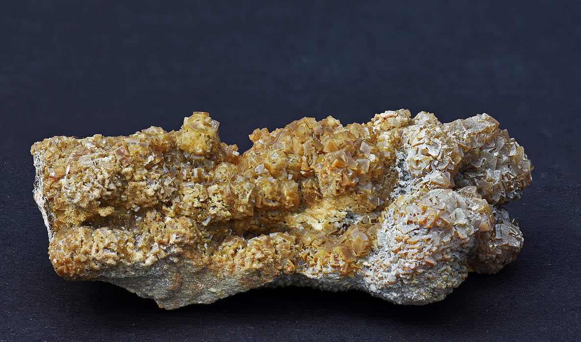
| Peak Hill Pty Mine, Peak Hill, Narromine Co., New South Wales, Australia | 32° 43' 22" S | 148° 11' 41" E | 0.9km (0.6 miles) | |
| Lamberts Mine, Peak Hill, Narromine Co., New South Wales, Australia | 32° 42' 56" S | 148° 12' 5" E | 1.0km (0.6 miles) | |
| Crown of Peak Hill Mine, Peak Hill, Narromine Co., New South Wales, Australia | 32° 43' 21" S | 148° 11' 50" E | 1.0km (0.6 miles) | |
| Bobby Burns Mine, Peak Hill, Narromine Co., New South Wales, Australia | 32° 43' 35" S | 148° 12' 8" E | 1.6km (1.0 miles) | |
| Paddys Flat Diggings, Peak Hill, Narromine Co., New South Wales, Australia | 32° 43' 45" S | 148° 13' 5" E | 3.0km (1.8 miles) | |
| Airstrip Prospect, Peak Hill, Narromine Co., New South Wales, Australia | 32° 44' 10" S | 148° 12' 47" E | 3.1km (1.9 miles) | |
| The Bluff Mine, Peak Hill, Narromine Co., New South Wales, Australia | 32° 45' 47" S | 148° 12' 31" E | 5.6km (3.5 miles) | |
| Smiths Mine, Peak Hill, Narromine Co., New South Wales, Australia | 32° 39' 8" S | 148° 12' 17" E | 7.1km (4.4 miles) | |
| Black Snake Mine, Peak Hill, Narromine Co., New South Wales, Australia | 32° 46' 39" S | 148° 12' 49" E | 7.3km (4.5 miles) | |
| Turners Mine, Peak Hill, Narromine Co., New South Wales, Australia | 32° 47' 21" S | 148° 13' 24" E | 8.8km (5.5 miles) | |
| Who'D A Thought It Mine, Trewilga, Kennedy Co., New South Wales, Australia | 32° 49' 26" S | 148° 13' 1" E | 12.3km (7.7 miles) | |
| Monte Carlo Mine, Trewilga, Kennedy Co., New South Wales, Australia | 32° 49' 40" S | 148° 13' 41" E | 13.0km (8.1 miles) | |
| Wyoming deposits, Tomingley, Narromine Co., New South Wales, Australia | 32° 35' 15" S | 148° 13' 5" E | 14.4km (9.0 miles) | |
| Mickibri Prospect, Trewilga, Kennedy Co., New South Wales, Australia | 32° 50' 47" S | 148° 12' 40" E | 14.7km (9.1 miles) | |
| Myall United Mine (Myall's United Mine), Tomingley, Narromine Co., New South Wales, Australia | 32° 35' 2" S | 148° 13' 20" E | 14.9km (9.3 miles) | |
| Patons Mine, Tomingley, Narromine Co., New South Wales, Australia | 32° 34' 27" S | 148° 13' 25" E | 16.0km (9.9 miles) | |
| Tomingley, Narromine Co., New South Wales, Australia | 32° 34' 10" S | 148° 13' 20" E | 16.4km (10.2 miles) | |
| Crowhurst and Sons Mine, Tomingley, Narromine Co., New South Wales, Australia | 32° 34' 7" S | 148° 13' 22" E | 16.6km (10.3 miles) | |
| Centenary Mine, Tomingley, Narromine Co., New South Wales, Australia | 32° 33' 55" S | 148° 13' 23" E | 16.9km (10.5 miles) | |
| Great Britain Mine, Alectown, Kennedy Co., New South Wales, Australia | 32° 50' 22" S | 148° 18' 1" E | 17.2km (10.7 miles) | |
| Emu Reef Mine, Alectown, Kennedy Co., New South Wales, Australia | 32° 51' 1" S | 148° 17' 15" E | 17.5km (10.9 miles) | |
| Coradgery Mine, Alectown, Kennedy Co., New South Wales, Australia | 32° 51' 54" S | 148° 2' 41" E | 21.6km (13.4 miles) | |
| Stockmans Mine, Alectown, Kennedy Co., New South Wales, Australia | 32° 54' 51" S | 148° 15' 54" E | 23.2km (14.4 miles) | |
| Wombin Mine, Northparkes Mine Project, Goonumbla, Kennedy Co., New South Wales, Australia | 32° 53' 39" S | 148° 3' 32" E | 23.4km (14.6 miles) | |
| Endeavour 27, Northparkes Mine Project, Goonumbla, Kennedy Co., New South Wales, Australia | 32° 54' 30" S | 148° 3' 0" E | 25.2km (15.7 miles) | |
| Spider Mine, Alectown, Kennedy Co., New South Wales, Australia | 32° 56' 35" S | 148° 12' 34" E | 25.4km (15.8 miles) | |
| Cobweb Mine (Cobweb Diggings), Alectown, Kennedy Co., New South Wales, Australia | 32° 56' 52" S | 148° 12' 12" E | 25.9km (16.1 miles) | |


Peak Hill Pty Mine, Peak Hill, Narromine Co., New South Wales, Australia