Log InRegister
Quick Links : The Mindat ManualThe Rock H. Currier Digital LibraryMindat Newsletter [Free Download]
Home PageAbout MindatThe Mindat ManualHistory of MindatCopyright StatusWho We AreContact UsAdvertise on Mindat
Donate to MindatCorporate SponsorshipSponsor a PageSponsored PagesMindat AdvertisersAdvertise on Mindat
Learning CenterWhat is a mineral?The most common minerals on earthInformation for EducatorsMindat ArticlesThe ElementsThe Rock H. Currier Digital LibraryGeologic Time
Minerals by PropertiesMinerals by ChemistryAdvanced Locality SearchRandom MineralRandom LocalitySearch by minIDLocalities Near MeSearch ArticlesSearch GlossaryMore Search Options
Search For:
Mineral Name:
Locality Name:
Keyword(s):
 
The Mindat ManualAdd a New PhotoRate PhotosLocality Edit ReportCoordinate Completion ReportAdd Glossary Item
Mining CompaniesStatisticsUsersMineral MuseumsClubs & OrganizationsMineral Shows & EventsThe Mindat DirectoryDevice SettingsThe Mineral Quiz
Photo SearchPhoto GalleriesSearch by ColorNew Photos TodayNew Photos YesterdayMembers' Photo GalleriesPast Photo of the Day GalleryPhotography

Nearest Localities

Results - nearest recorded localities to 22° 1' 5" N,26° 5' 14" E

LocalityLatitudeLongitudeDistanceBearing
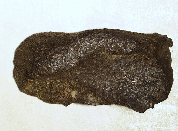
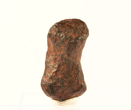
Gebel Kamil meteorite, Gebel Kamil Crater (Kamil Crater), East Uweinat Desert, New Valley Governorate, Egypt22° 1' 5" N26° 5' 14" E0.0km (0.0 miles)
Gebel Kamil Crater (Kamil Crater), East Uweinat Desert, New Valley Governorate, Egypt22° 1' 5" N26° 5' 14" E0.0km (0.0 miles)
Crater Hills Complex, New Valley Governorate, Egypt22° 19' 59" N25° 30' 0" E69.9km (43.4 miles)
East Uweinat Desert, New Valley Governorate, Egypt22° 13' 26" N25° 19' 14" E82.2km (51.1 miles)
Northeast Africa 001, Northern State, Sudan21° 0' 0" N26° 0' 0" E113.6km (70.6 miles)
Jebel Uweinat, Kufra District, Libya21° 55' 0" N24° 55' 0" E121.3km (75.4 miles)
Jabal Babein Intrusion, Kufra District, Libya22° 40' 0" N24° 55' 0" E140.3km (87.2 miles)
Jebel Arkenu, Kufra District, Libya22° 16' 0" N24° 41' 59" E145.5km (90.4 miles)
Jabal al Bahri Intrusion, Kufra District, Libya22° 36' 0" N24° 41' 59" E156.7km (97.4 miles)
Chazzi Hill Ring Complex, Kufra District, Libya21° 25' 0" N24° 31' 59" E173.9km (108.1 miles)
Sandara Hill Plug, Kufra District, Libya21° 16' 0" N24° 13' 59" E209.1km (129.9 miles)

Minerals recorded nearby (within 20 km)

Rock types recorded nearby (within 20 km)

Regions in mindat.org that contain this locality

RegionType
African PlateTectonic Plate
EgyptCountry
New Valley Governorate, EgyptGovernorate
Sahara Desert, North AfricaDesert

Regions in GADM Database

RegionGADM number
Egypt, Al Wadi al Jadid, Shurtah al-Dakhlah69.14.193.0.0.0
 
Mineral and/or Locality  
Mindat Discussions Facebook Logo Instagram Logo Discord Logo
Mindat.org is an outreach project of the Hudson Institute of Mineralogy, a 501(c)(3) not-for-profit organization.
Copyright © mindat.org and the Hudson Institute of Mineralogy 1993-2024, except where stated. Most political location boundaries are © OpenStreetMap contributors. Mindat.org relies on the contributions of thousands of members and supporters. Founded in 2000 by Jolyon Ralph.
Privacy Policy - Terms & Conditions - Contact Us / DMCA issues - Report a bug/vulnerability Current server date and time: April 18, 2024 21:15:00
Go to top of page