| Locality | Latitude | Longitude | Distance | Bearing |
|---|
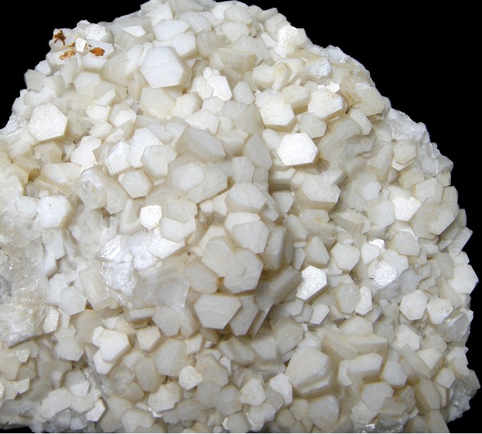
| Lane Quarry, Northfield, Franklin County, Massachusetts, USA | 42° 41' 39" N | 72° 28' 36" W | 0.0km (0.0 miles) | |
| Brush Mountain, Northfield, Franklin County, Massachusetts, USA | 42° 40' 29" N | 72° 25' 58" W | 4.2km (2.6 miles) | |
| Ross's Lead Mine, Northfield, Franklin County, Massachusetts, USA | 42° 43' 34" N | 72° 26' 34" W | 4.5km (2.8 miles) | |
| Piper graphite mine (Piper black-lead mine), Northfield, Franklin County, Massachusetts, USA | 42° 39' 15" N | 72° 25' 18" W | 6.4km (3.9 miles) | |
| Sky Farm, Northfield, Franklin County, Massachusetts, USA | 42° 38' 24" N | 72° 25' 12" W | 7.6km (4.7 miles) | |
| Vernon, Windham County, Vermont, USA | 42° 46' 5" N | 72° 31' 9" W | 8.9km (5.5 miles) | |
| Mount Grace, Warwick, Franklin County, Massachusetts, USA | 42° 41' 27" N | 72° 21' 18" W | 10.0km (6.2 miles) | |
| Hinsdale, Cheshire County, New Hampshire, USA | 42° 47' 9" N | 72° 29' 11" W | 10.2km (6.4 miles) | |
| Winchester, Cheshire County, New Hampshire, USA | 42° 46' 23" N | 72° 22' 59" W | 11.7km (7.2 miles) | |
| Guilford, Windham County, Vermont, USA | 42° 45' 59" N | 72° 37' 35" W | 14.6km (9.1 miles) | |
| Orange mica mine, Orange, Franklin County, Massachusetts, USA | 42° 37' 59" N | 72° 18' 58" W | 14.8km (9.2 miles) | |
| Richmond Soapstone Quarry, Richmond, Cheshire County, New Hampshire, USA | 42° 44' 8" N | 72° 17' 39" W | 15.6km (9.7 miles) | |
| Cheapside Quarry (East Deerfield Quarry; Trew Corp. Quarry), Deerfield, Franklin County, Massachusetts, USA | 42° 33' 54" N | 72° 35' 3" W | 16.8km (10.5 miles) | |
| Richmond, Cheshire County, New Hampshire, USA | 42° 45' 16" N | 72° 16' 18" W | 18.1km (11.2 miles) | |
| Brattleboro, Windham County, Vermont, USA | 42° 51' 15" N | 72° 33' 30" W | 19.0km (11.8 miles) | |
| Catamount Hill, Colrain, Franklin County, Massachusetts, USA | 42° 39' 29" N | 72° 44' 3" W | 21.4km (13.3 miles) | |
| Chesterfield, Cheshire County, New Hampshire, USA | 42° 53' 13" N | 72° 28' 13" W | 21.4km (13.3 miles) | |
| Route 2 Calcite locality, Shelburne, Franklin County, Massachusetts, USA | 42° 35' 12" N | 72° 41' 49" W | 21.6km (13.4 miles) | |
| Wilson Hill, Colrain, Franklin County, Massachusetts, USA | 42° 42' 27" N | 72° 44' 38" W | 21.9km (13.6 miles) | |
| Swanzey, Cheshire County, New Hampshire, USA | 42° 52' 10" N | 72° 16' 54" W | 25.2km (15.6 miles) | |
| Dummerston granite quarry, Dummerston, Windham County, Vermont, USA | 42° 54' 49" N | 72° 36' 15" W | 26.5km (16.5 miles) | |
| Dummerston, Windham County, Vermont, USA | 42° 55' 20" N | 72° 34' 40" W | 26.7km (16.6 miles) | |
| Reynolds Mine (Beryl Hill Mine), Royalston, Worcester County, Massachusetts, USA | 42° 41' 28" N | 72° 8' 38" W | 27.2km (16.9 miles) | |
| Yon Granite Quarry, Fitzwilliam, Cheshire County, New Hampshire, USA | 42° 44' 20" N | 72° 8' 55" W | 27.3km (16.9 miles) | |
| South Royalston beryl locality (Clark locality), Royalston, Worcester County, Massachusetts, USA | 42° 37' 56" N | 72° 9' 3" W | 27.5km (17.1 miles) | |
| Webb Granite Quarry, Fitzwilliam, Cheshire County, New Hampshire, USA | 42° 45' 24" N | 72° 9' 1" W | 27.6km (17.1 miles) | |
| Troy, Cheshire County, New Hampshire, USA | 42° 49' 30" N | 72° 11' 0" W | 28.0km (17.4 miles) | |
| Marlboro, Windham County, Vermont, USA | 42° 51' 47" N | 72° 43' 55" W | 28.0km (17.4 miles) | |
| Silver White Granite Quarry, Fitzwilliam, Cheshire County, New Hampshire, USA | 42° 46' 8" N | 72° 8' 49" W | 28.2km (17.5 miles) | |
| William Wise Mine, Westmoreland, Cheshire County, New Hampshire, USA | 42° 57' 1" N | 72° 29' 11" W | 28.5km (17.7 miles) | |


Vernon, Windham County, Vermont, USA