| Locality | Latitude | Longitude | Distance | Bearing |
|---|
| Gailor Quarry, Saratoga Springs, Saratoga County, New York, USA | 43° 4' 59" N | 73° 46' 59" W | 0.0km (0.0 miles) | |
| Saratoga Springs, Saratoga County, New York, USA | 43° 4' 59" N | 73° 46' 59" W | 0.0km (0.0 miles) | |
| Belgian Block Quarry, Granite Mountain, Saratoga Springs, Saratoga County, New York, USA | 43° 4' 59" N | 73° 46' 59" W | 0.0km (0.0 miles) | |
| Greenfield pegmatite, Greenfield Township, Saratoga County, New York, USA | 43° 6' 29" N | 73° 46' 53" W | 2.8km (1.7 miles) | |
| Lester Park, Greenfield Township, Saratoga County, New York, USA | 43° 5' 32" N | 73° 50' 53" W | 5.4km (3.3 miles) | |
| Greenfield, Greenfield Township, Saratoga County, New York, USA | 43° 6' 12" N | 73° 51' 51" W | 7.0km (4.3 miles) | |
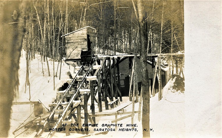
| Flake Graphite Company Mine (Empire Graphite Company Mine), Greenfield Township, Saratoga County, New York, USA | 43° 5' 59" N | 73° 54' 0" W | 9.7km (6.0 miles) | |
| Corinth pegmatite outcrop, Corinth, Saratoga County, New York, USA | 43° 12' 0" N | 73° 52' 59" W | 15.3km (9.5 miles) | |
| Graphite Products Corp. Mine (Saratoga Graphite Company Mine), Wilton Township, Saratoga County, New York, USA | 43° 15' 0" N | 73° 45' 0" W | 18.7km (11.6 miles) | |
| Overlook Quarry (Atlas Feldspar Company Quarry; Atlas Quarry; Day Quarry), Overlook, Saratoga County, New York, USA | 43° 17' 30" N | 73° 56' 44" W | 26.6km (16.6 miles) | |
| Tomhannock Creek meteorite, Ironhannock Creek, Rensselaer County, New York, USA | 42° 52' 59" N | 73° 35' 59" W | 26.8km (16.6 miles) | |
| Gordon Creek locality, Batchellerville, Edinburg Township, Saratoga County, New York, USA | 43° 12' 29" N | 74° 5' 0" W | 28.0km (17.4 miles) | |
| Schenectady meteorite, Glenville, Schenectady County, New York, USA | 42° 51' 38" N | 73° 57' 1" W | 28.2km (17.5 miles) | |
| Garnet Pit, Batchellerville, Edinburg Township, Saratoga County, New York, USA | 43° 14' 21" N | 74° 3' 33" W | 28.3km (17.6 miles) | |
| Batchellerville, Saratoga County, New York, USA | 43° 14' 20" N | 74° 3' 36" W | 28.3km (17.6 miles) | |
| Mohawk Quarry, Batchellerville, Saratoga County, New York, USA | 43° 13' 0" N | 74° 5' 0" W | 28.5km (17.7 miles) | |
| Sacandaga Graphite Company Mine (Glen Falls Graphite Company Mine), Conklingville, Sacandaga Valley, Day Township, Saratoga County, New York, USA | 43° 18' 59" N | 73° 56' 59" W | 29.3km (18.2 miles) | |
| Claspka Mining Company Quarry, Batchellerville, Edinburg Township, Saratoga County, New York, USA | 43° 15' 0" N | 74° 5' 0" W | 30.6km (19.0 miles) | |
| Richard Tyrell Farm Pegmatite Quarry, Richard Tyrell farm, Cranberry Creek, Mayfield, Fulton County, New York, USA | 43° 5' 59" N | 74° 16' 0" W | 39.3km (24.4 miles) | |
| Werner Prospect 1, Mayfield, Fulton County, New York, USA | 43° 10' 20" N | 74° 15' 10" W | 39.4km (24.5 miles) | |
| Fort Ann, Washington County, New York, USA | 43° 24' 51" N | 73° 29' 14" W | 43.9km (27.3 miles) | |
| Mammoth Cave prospect, Warrensburg, Warrensburg Township, Warren County, New York, USA | 43° 30' 0" N | 73° 46' 30" W | 46.3km (28.8 miles) | |
| Altamont Village, Town of Guilderland, Albany County, New York, USA | 42° 42' 17" N | 74° 2' 2" W | 46.8km (29.1 miles) | |
| Dominick Ashley Quarry, Putnam Mountain, Fort Ann, Washington County, New York, USA | 43° 29' 29" N | 73° 31' 50" W | 49.8km (30.9 miles) | |
| Bennington, Bennington County, Vermont, USA | 42° 53' 27" N | 73° 12' 29" W | 51.4km (32.0 miles) | |
| New Scotland, Albany County, New York, USA | 42° 37' 42" N | 73° 54' 47" W | 51.7km (32.1 miles) | |
| West Pawlet, Pawlet, Rutland County, Vermont, USA | 43° 21' 14" N | 73° 15' 6" W | 52.5km (32.6 miles) | |
| Glenmont, Albany County, New York, USA | 42° 36' 16" N | 73° 46' 9" W | 53.2km (33.1 miles) | |
| Champlain Graphite Company Mine, Dresden Township, Washington County, New York, USA | 43° 30' 0" N | 73° 26' 59" W | 53.6km (33.3 miles) | |
| Pownal quarry, Pownal, Bennington County, Vermont, USA | 42° 47' 35" N | 73° 15' 18" W | 53.8km (33.4 miles) | |
Minerals recorded nearby (within 20 km)
Rock types recorded nearby (within 20 km)
Entries shown in red are rocks recorded for this region.
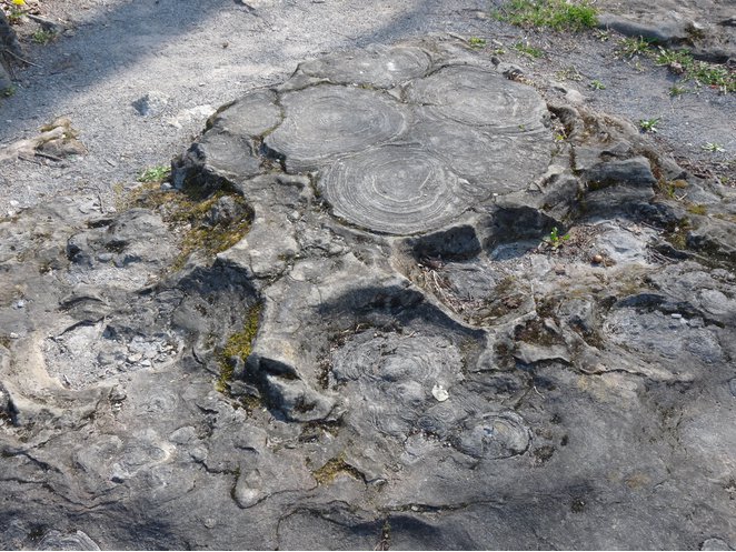


Lester Park, Greenfield Township, Saratoga County, New York, USA