| Locality | Latitude | Longitude | Distance | Bearing |
|---|
| Ruggles Mine, Grafton, Grafton County, New Hampshire, USA | 43° 35' 26" N | 71° 59' 27" W | 0.0km (0.0 miles) | |
| Hoyt Hill Quarry, Orange, Grafton County, New Hampshire, USA | 43° 38' 6" N | 71° 56' 52" W | 6.0km (3.8 miles) | |
| Aaron's Ledge Mine, Springfield, Sullivan County, New Hampshire, USA | 43° 32' 8" N | 72° 1' 7" W | 6.5km (4.0 miles) | |
| Standard Mine, Orange, Grafton County, New Hampshire, USA | 43° 39' 36" N | 71° 57' 29" W | 8.2km (5.1 miles) | |
| George Hill, Springfield, Sullivan County, New Hampshire, USA | 43° 33' 6" N | 72° 4' 55" W | 8.5km (5.3 miles) | |
| Summit Mine, Grafton, Grafton County, New Hampshire, USA | 43° 32' 56" N | 71° 53' 33" W | 9.2km (5.7 miles) | |
| Ford Garnet Mine, Danbury, Merrimack County, New Hampshire, USA | 43° 31' 32" N | 71° 53' 43" W | 10.6km (6.6 miles) | |
| Springfield, Sullivan County, New Hampshire, USA | 43° 29' 43" N | 72° 2' 3" W | 11.2km (6.9 miles) | |
| No. 5 pit, Keyes Mica Quarries, Orange, Grafton County, New Hampshire, USA | 43° 41' 22" N | 71° 56' 42" W | 11.6km (7.2 miles) | |
| New Haven Mica Quarry, Alexandria, Grafton County, New Hampshire, USA | 43° 37' 13" N | 71° 50' 56" W | 11.9km (7.4 miles) | |
| No. 1 pit, Keyes Mica Quarries, Orange, Grafton County, New Hampshire, USA | 43° 41' 32" N | 71° 56' 32" W | 12.0km (7.4 miles) | |
| Keyes Mica Quarries, Orange, Grafton County, New Hampshire, USA | 43° 41' 32" N | 71° 56' 32" W | 12.0km (7.4 miles) | |
| Pattuck Quarry, Alexandria, Grafton County, New Hampshire, USA | 43° 37' 0" N | 71° 50' 37" W | 12.2km (7.6 miles) | |
| No. 3 pit, Keyes Mica Quarries, Orange, Grafton County, New Hampshire, USA | 43° 41' 42" N | 71° 56' 30" W | 12.3km (7.6 miles) | |
| Mud Mica Mine, Alexandria, Grafton County, New Hampshire, USA | 43° 36' 21" N | 71° 50' 13" W | 12.5km (7.8 miles) | |
| E.E. Smith Mine, Alexandria, Grafton County, New Hampshire, USA | 43° 37' 3" N | 71° 50' 14" W | 12.7km (7.9 miles) | |
| Lower quarry, E.E. Smith Mine, Alexandria, Grafton County, New Hampshire, USA | 43° 37' 0" N | 71° 50' 12" W | 12.8km (7.9 miles) | |
| Middle pegmatite, E.E. Smith Mine, Alexandria, Grafton County, New Hampshire, USA | 43° 37' 4" N | 71° 50' 13" W | 12.8km (7.9 miles) | |
| Bullock Quarry, E.E. Smith Mine, Alexandria, Grafton County, New Hampshire, USA | 43° 37' 9" N | 71° 50' 13" W | 12.8km (7.9 miles) | |
| Truman Patten Quarry, Alexandria, Grafton County, New Hampshire, USA | 43° 38' 56" N | 71° 51' 7" W | 12.9km (8.0 miles) | |
| Wadhams-Tucker Quarry, Alexandria, Grafton County, New Hampshire, USA | 43° 38' 9" N | 71° 49' 45" W | 14.0km (8.7 miles) | |
| Itaska mine, Alexandria, Grafton County, New Hampshire, USA | 43° 38' 38" N | 71° 49' 55" W | 14.1km (8.8 miles) | |
| Monarch Quarry, Alexandria, Grafton County, New Hampshire, USA | 43° 38' 47" N | 71° 49' 56" W | 14.2km (8.8 miles) | |
| Marston Quarry, Alexandria, Grafton County, New Hampshire, USA | 43° 39' 24" N | 71° 50' 10" W | 14.5km (9.0 miles) | |
| Morgan Mica prospect, Alexandria, Grafton County, New Hampshire, USA | 43° 39' 54" N | 71° 50' 9" W | 15.0km (9.3 miles) | |
| Grantham, Sullivan County, New Hampshire, USA | 43° 29' 21" N | 72° 8' 15" W | 16.3km (10.2 miles) | |
| Hobart Hill, Hebron, Grafton County, New Hampshire, USA | 43° 41' 17" N | 71° 49' 23" W | 17.3km (10.8 miles) | |
| Rice Quarry, Groton, Grafton County, New Hampshire, USA | 43° 44' 42" N | 71° 53' 47" W | 18.8km (11.7 miles) | |
| Ragged Mountain locality, Andover, Merrimack County, New Hampshire, USA | 43° 28' 5" N | 71° 49' 45" W | 18.9km (11.7 miles) | |
| Palermo No. 2 Mine, Groton, Grafton County, New Hampshire, USA | 43° 45' 6" N | 71° 53' 33" W | 19.6km (12.2 miles) | |
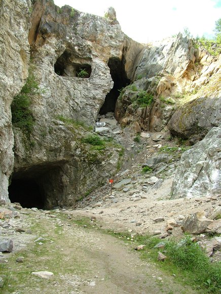


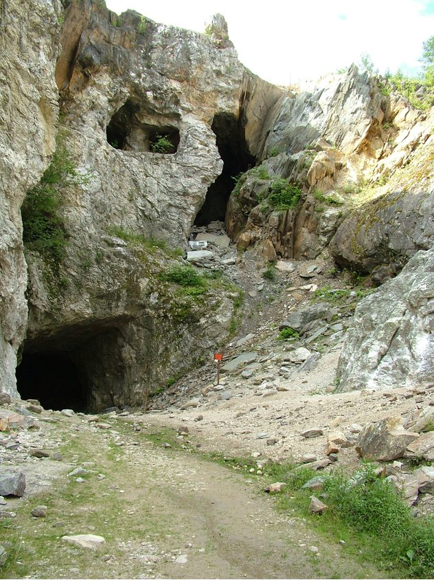


Ruggles Mine, Grafton, Grafton County, New Hampshire, USA